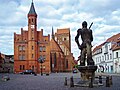
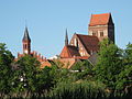
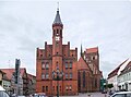
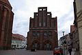
Category:Town hall in Perleberg
town hall in Perleberg, Brandenburg state, Germany  | |||||
| Upload media | |||||
| Instance of | |||||
|---|---|---|---|---|---|
| Location | Perleberg, Prignitz District, Brandenburg, Germany | ||||
| Heritage designation | |||||
 | |||||
This is the category of the Brandenburger Baudenkmal (cultural heritage monument) with the ID 09160357 (Wikidata)
|
Media in category "Town hall in Perleberg"
The following 23 files are in this category, out of 23 total.
-
 Gedenktafel Großer Markt 1 (Perleberg) Perleberger Rathaus.jpg 1,251 × 987; 459 KB
-
 Gottheil-Poppel-Kurz Der-Markt-in-Perleberg beschriftet.png 3,742 × 2,827; 7.29 MB
-
 Gottheil-Poppel-Kurz Der-Markt-in-Perleberg.jpg 1,707 × 1,138; 943 KB
-
 Großer markt 1.jpg 4,000 × 3,000; 4.3 MB
-
 Großer Markt 2980.jpg 640 × 480; 241 KB
-
 Perleberg town hall.jpg 1,470 × 1,920; 596 KB
-
 Perleberg, the town hall.jpg 1,772 × 2,389; 595 KB
-
 Perleberger Rathaus 1.JPG 1,704 × 2,272; 755 KB
-
 Perleberger Rathaus 6.JPG 4,000 × 3,000; 3.17 MB
-
 Perleberger Rathaus 7.JPG 4,000 × 3,000; 3.36 MB
-
 Perleberger Rathaus und Kirche.JPG 2,816 × 2,112; 1.26 MB
-
 Rathaus 10.JPG 3,000 × 4,000; 3.16 MB
-
 Rathaus 3.JPG 3,000 × 4,000; 4.22 MB
-
 Rathaus 4.JPG 4,000 × 3,000; 3.56 MB
-
 Rathaus 5.JPG 4,000 × 3,000; 3.36 MB
-
 Rathaus 6 Perleberg.JPG 3,000 × 4,000; 2.64 MB
-
 Rathaus 6.JPG 3,000 × 4,000; 4 MB
-
 Rathaus 7.JPG 3,000 × 4,000; 3.03 MB
-
 Rathaus Perleberg 11.JPG 4,000 × 3,000; 3.1 MB
-
 Rathaus Perleberg Ostseite 2011 (bearb Sp).jpg 3,391 × 2,524; 4.65 MB
-
 Rathaus Perleberg Ostseite 2011.jpg 3,691 × 2,471; 4.31 MB
-
 Rathaus Rückseite Perleberg (bearb Sp).jpg 3,740 × 2,560; 1.84 MB
-
 Rathaus Rückseite Perleberg.jpg 3,872 × 2,592; 1.19 MB
_Perleberger_Rathaus.jpg)


.jpg)
.jpg)
