Category:United Kingdom photographs taken on 2004-03-13
Countries of Europe: Czech Republic · Finland · France‡ · Germany · Greece · Republic of Ireland · Russia‡ · Serbia · Spain‡ · Switzerland · United Kingdom
‡: partly located in Europe
‡: partly located in Europe
| ← | 13 March 2004 | → | ||
| ← | March 2004 | → | ||

United Kingdom photographs taken on 13 March 2004.
Image files should be categorized here automatically using {{taken on}} template. Direct categorisation is also possible, if automatic is impossible.
Media in category "United Kingdom photographs taken on 2004-03-13"
The following 40 files are in this category, out of 40 total.
-
 Arran Ferry at Brodick Pier - geograph.org.uk - 164345.jpg 400 × 300; 8 KB
-
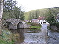 Badgworthy Water Malmsmead.jpg 640 × 480; 133 KB
-
 Blaen y Pennant house - geograph.org.uk - 1201770.jpg 640 × 480; 111 KB
-
 Chesil Beach - geograph.org.uk - 113002.jpg 640 × 480; 83 KB
-
 Church of St Helena, Willoughby, Lincs - geograph.org.uk - 49744.jpg 640 × 480; 359 KB
-
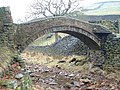 Close Gate Bridge - geograph.org.uk - 82605.jpg 640 × 480; 164 KB
-
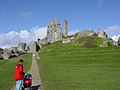 Corfe Castle - geograph.org.uk - 17.jpg 640 × 480; 63 KB
-
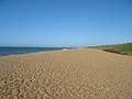
 Fistral Beach - geograph.org.uk - 10767.jpg 640 × 480; 70 KB
-
 Forestry road in the Myherin valley - geograph.org.uk - 522518.jpg 640 × 480; 98 KB
-

-
 Hegdon Hill - geograph.org.uk - 7864.jpg 640 × 480; 124 KB
-

-
 Longnor - geograph.org.uk - 22704.jpg 640 × 480; 106 KB
-
 Malmsmead Hill, Exmoor - geograph.org.uk - 80944.jpg 640 × 480; 111 KB
-
 Mawgan Porth Beach - geograph.org.uk - 6819.jpg 640 × 481; 111 KB
-
 Monsal Head - geograph.org.uk - 494.jpg 640 × 480; 46 KB
-
 Nearing Blaen Myherin - geograph.org.uk - 522534.jpg 640 × 464; 88 KB
-
 Ness Gardens - geograph.org.uk - 329936.jpg 540 × 398; 113 KB
-
 Ness Gardens - geograph.org.uk - 329939.jpg 570 × 422; 110 KB
-
 Park Head - geograph.org.uk - 6817.jpg 640 × 469; 107 KB
-
 Pilsbury Castle Hills - geograph.org.uk - 22734.jpg 640 × 480; 98 KB
-
 Point of Ayr Lighthouse - geograph.org.uk - 444728.jpg 640 × 430; 39 KB
-
 Quay West - geograph.org.uk - 838276.jpg 640 × 473; 83 KB
-
 Saddleworth Viaduct, Huddersfield Canal.jpg 480 × 640; 129 KB
-
 Slip Cove - geograph.org.uk - 10762.jpg 640 × 480; 113 KB
-
-
 Stoke Sub Hamdon, Somerset - geograph.org.uk - 66471.jpg 640 × 480; 118 KB
-
 The Afon Myherin near its end - geograph.org.uk - 1631148.jpg 640 × 480; 171 KB
-
 The Lowry Bridge - geograph.org.uk - 838283.jpg 640 × 480; 49 KB
-
 The rape of Easington - geograph.org.uk - 627015.jpg 587 × 440; 73 KB
-
 Thompson B1 No. 61264 - 2004-03-13.jpg 2,592 × 1,944; 2.08 MB
-
 Thorney Island - geograph.org.uk - 18781.jpg 640 × 480; 68 KB
-
 Walkway onto Chesil Beach - geograph.org.uk - 113001.jpg 640 × 480; 111 KB
-
 Willoughby Arms, Willoughby, Lincs - geograph.org.uk - 87644.jpg 640 × 480; 261 KB
-
 Bridleway to the Gwy (Wye) valley - geograph.org.uk - 522561.jpg 640 × 480; 141 KB
-
 Old Dyke - geograph.org.uk - 174249.jpg 640 × 480; 151 KB
-
 Old Dyke - geograph.org.uk - 174250.jpg 640 × 480; 164 KB
-
 Old Rectory and drive, Willoughby, Lincs - geograph.org.uk - 87645.jpg 640 × 480; 431 KB
-
 The Afon Myherin - geograph.org.uk - 522554.jpg 640 × 494; 115 KB
-
 Trig point at 63m^^ - geograph.org.uk - 18133.jpg 640 × 480; 165 KB


.jpg)


_valley_-_geograph.org.uk_-_522561.jpg)


