Category:United Kingdom photographs taken on 2006-03-30
| ← | Thursday 30 March 2006 | → | ||
| ← | March 2006 | → | ||

United Kingdom photographs taken on 30 March 2006.
Image files should be categorized here automatically using {{taken on}} template. Direct categorisation is also possible, if automatic is impossible.
Media in category "United Kingdom photographs taken on 2006-03-30"
The following 200 files are in this category, out of 236 total.
(previous page) (next page)-
 A819 - geograph.org.uk - 151754.jpg 640 × 480; 87 KB
-
-
 Acurrach - geograph.org.uk - 151747.jpg 640 × 480; 75 KB
-
 Airside Terminal 1 - geograph.org.uk - 144587.jpg 640 × 458; 92 KB
-
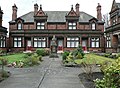
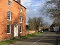
 Albury Park House.jpg 640 × 480; 91 KB
-
 Arlescott Farm near Much Wenlock - geograph.org.uk - 153734.jpg 640 × 480; 123 KB
-
-
 Back Lane, Colaton Raleigh - geograph.org.uk - 144440.jpg 640 × 480; 151 KB
-
 Beach at Rubha na Sgianadin - geograph.org.uk - 144263.jpg 640 × 480; 101 KB
-
 Beach near Corry - geograph.org.uk - 144274.jpg 640 × 480; 122 KB
-
 Beinn Ghlas, trigpoint - geograph.org.uk - 155629.jpg 640 × 480; 96 KB
-
 Beinn Ghlas. - geograph.org.uk - 151066.jpg 640 × 393; 82 KB
-
 Brockleys Farm, Thorpe Satchville Road - geograph.org.uk - 144477.jpg 640 × 427; 105 KB
-

-
 Baptist Church - geograph.org.uk - 144306.jpg 480 × 640; 95 KB
-
 Bushcliff House. - geograph.org.uk - 144204.jpg 640 × 480; 97 KB
-
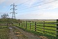
 Byway Open to All Traffic (BOAT) - geograph.org.uk - 144235.jpg 640 × 480; 129 KB
-
 Chastleton House 01.jpg 426 × 640; 133 KB
-
 Chastleton House 03.jpg 426 × 640; 115 KB
-
 Chastleton House 05.jpg 640 × 426; 139 KB
-

-
 Churchover - Bransford Bridge - geograph.org.uk - 144316.jpg 640 × 480; 160 KB
-
 Colaton Raleigh Common - geograph.org.uk - 144394.jpg 640 × 480; 130 KB
-
 Countryside near Baggrave Hall - geograph.org.uk - 144813.jpg 640 × 427; 122 KB
-
 Countryside near Thorpe Satchville - geograph.org.uk - 144478.jpg 640 × 427; 120 KB
-
 Daffodil fields and pickers - geograph.org.uk - 144386.jpg 640 × 480; 92 KB
-
 Danger area, Colaton Raleigh Common - geograph.org.uk - 144459.jpg 640 × 480; 118 KB
-
 Dismantled railway near Notton. - geograph.org.uk - 144205.jpg 640 × 480; 127 KB
-

-
 Draycott Cerne cemetery chapel. - geograph.org.uk - 144257.jpg 640 × 480; 104 KB
-
 Dry ground, Beinn Ghlas. - geograph.org.uk - 151054.jpg 640 × 480; 78 KB
-
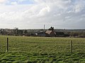
 Dwellings near Kington St. Michael - geograph.org.uk - 144585.jpg 640 × 480; 45 KB
-
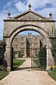 EntranceArchwayToChastleton House(PhilipHalling)Mar2006.jpg 426 × 640; 132 KB
-

-
 Field on Colaton Raleigh Common - geograph.org.uk - 144406.jpg 640 × 480; 134 KB
-
 Folville Street, Ashby Folville - geograph.org.uk - 144806.jpg 640 × 427; 159 KB
-
 Footpath across Chevet Park. - geograph.org.uk - 144214.jpg 640 × 480; 90 KB
-
 Footpath in the Garden Plantation. - geograph.org.uk - 144208.jpg 640 × 480; 153 KB
-
 Footpath off Day's Lane - geograph.org.uk - 144384.jpg 640 × 480; 87 KB
-
 Ford and footbridge near Stowford - geograph.org.uk - 144447.jpg 640 × 480; 156 KB
-
 From Chalk Pool Hill - geograph.org.uk - 144445.jpg 640 × 427; 119 KB
-

-
 Glacial deposits - geograph.org.uk - 150909.jpg 640 × 480; 84 KB
-
 Gorse Lane Water Tower - geograph.org.uk - 144535.jpg 427 × 640; 64 KB
-
 Graves in Hunslet Cemetery - geograph.org.uk - 144642.jpg 480 × 640; 106 KB
-

-
 Grenade range, Colaton Raleigh Common - geograph.org.uk - 144464.jpg 640 × 480; 89 KB
-
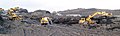 Grimethorpe 'muck' stack remediation - geograph.org.uk - 481951.jpg 640 × 193; 61 KB
-
 Harborough Magna - geograph.org.uk - 144324.jpg 640 × 480; 172 KB
-
 Hawkerland Valley - geograph.org.uk - 144421.jpg 640 × 480; 113 KB
-
 Head of Loch Ainort - geograph.org.uk - 144247.jpg 640 × 480; 104 KB
-
 Howe Hill from the South - geograph.org.uk - 144972.jpg 640 × 348; 44 KB
-
 Huntsham, possible course of Roman road - geograph.org.uk - 144382.jpg 640 × 427; 230 KB
-
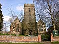
 St Peter's Church, Isham, Northants - geograph.org.uk - 144325.jpg 640 × 480; 81 KB
-
-

-
 St Cuthberts Church Kirby Ireleth.jpg 480 × 640; 118 KB
-
 Kitts Hayes - geograph.org.uk - 144435.jpg 640 × 480; 112 KB
-
 Ladbroke House - geograph.org.uk - 144317.jpg 640 × 480; 411 KB
-
 Ladbroke, Warks.jpg 640 × 480; 365 KB
-
 Langley Gate Farm - geograph.org.uk - 144584.jpg 640 × 480; 59 KB
-

-
 Lesnes Abbey ruins - geograph.org.uk - 871558.jpg 640 × 480; 78 KB
-
 Lesnes Abbey ruins, Belvedere, Kent - geograph.org.uk - 144246.jpg 640 × 480; 100 KB
-

-
 Loch Shira - geograph.org.uk - 151923.jpg 640 × 532; 170 KB
-
 Lochan on Beinn Ghlas - geograph.org.uk - 151070.jpg 640 × 480; 90 KB
-
 Logpile - geograph.org.uk - 151749.jpg 640 × 480; 98 KB
-
 Lone tree on Chevet farmland. - geograph.org.uk - 144210.jpg 640 × 480; 50 KB
-
 M621 from Middleton Road - geograph.org.uk - 144635.jpg 480 × 640; 65 KB
-
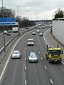
 M621 from Middleton Road bridge - geograph.org.uk - 144506.jpg 640 × 480; 91 KB
-
 The Ancient Maghull Chapel - geograph.org.uk - 327544.jpg 540 × 399; 106 KB
-

-
-
 Maol Ban - geograph.org.uk - 144256.jpg 640 × 480; 87 KB
-
 Moorland, west of Beinn Ghlas. - geograph.org.uk - 151052.jpg 640 × 480; 76 KB
-
 Murrayshall Quarry entrance - geograph.org.uk - 155795.jpg 640 × 480; 158 KB
-
 Near Hawkerland - geograph.org.uk - 144417.jpg 640 × 480; 87 KB
-
 Newlands Green - geograph.org.uk - 144345.jpg 640 × 480; 79 KB
-
 No swimming. Deep Water. - geograph.org.uk - 144538.jpg 640 × 480; 185 KB
-
 North Shore of Loch Ainort - geograph.org.uk - 144252.jpg 640 × 480; 111 KB
-
 Oxford Canal - geograph.org.uk - 498937.jpg 640 × 480; 119 KB
-
 Oxford Canal - geograph.org.uk - 498946.jpg 640 × 480; 112 KB
-

-
-
 Railway Bridge at Prora, near Drem - geograph.org.uk - 144234.jpg 640 × 524; 111 KB
-
 Railway by the Severn - geograph.org.uk - 144215.jpg 640 × 480; 108 KB
-
 Riverside Walk - geograph.org.uk - 149162.jpg 640 × 480; 141 KB
-
 Road Junction, Hinton Blewett - geograph.org.uk - 146612.jpg 481 × 640; 72 KB
-
 Roadside quarry - geograph.org.uk - 151925.jpg 640 × 480; 136 KB
-
 Rock ridges, Beinn Ghlas. - geograph.org.uk - 151061.jpg 640 × 480; 101 KB
-
 Rubbish on the Verge - geograph.org.uk - 144480.jpg 640 × 427; 190 KB
-
 The church at St Michael Caerhays - geograph.org.uk - 144373.jpg 640 × 480; 112 KB
-
 Sanctuary Farm - geograph.org.uk - 144397.jpg 640 × 480; 110 KB
-
 Sgeir Fasair-choille - geograph.org.uk - 144260.jpg 640 × 480; 92 KB
-
 Sheep by Gaddesby Lane (Frisby section) - geograph.org.uk - 144461.jpg 640 × 427; 124 KB
-
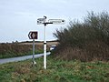 Signpost at junction near Vose farm - geograph.org.uk - 144378.jpg 640 × 480; 83 KB
-
 Southwest to Northeast, Beinn Ghlas. - geograph.org.uk - 151083.jpg 640 × 480; 80 KB
-
 St Andrew's Church, Twyford - geograph.org.uk - 144793.jpg 640 × 427; 112 KB
-
 St Nicholas Church, Oddington - geograph.org.uk - 147513.jpg 640 × 426; 107 KB
-
 St. Giles, Stanton St. Quintin - geograph.org.uk - 144301.jpg 640 × 480; 99 KB
-
 St. Mary's church, Stifford, Essex - geograph.org.uk - 149284.jpg 640 × 491; 73 KB
-

-

-
 St. Peters, Kington Langley - geograph.org.uk - 144266.jpg 640 × 480; 99 KB
-
 Stabilising Marine Parade - geograph.org.uk - 410216.jpg 640 × 480; 123 KB
-
 Stabilising work Marine parade Lyme Regis - geograph.org.uk - 410224.jpg 640 × 480; 120 KB
-
 Stoneyford - geograph.org.uk - 144429.jpg 640 × 480; 129 KB
-
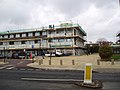
 Student accommodation - geograph.org.uk - 506344.jpg 640 × 601; 165 KB
-

-

-
 The eastern edge of Kings Wood. - geograph.org.uk - 144212.jpg 640 × 480; 138 KB
-

-
 The Grey House at Draycott Cerne - geograph.org.uk - 144330.jpg 640 × 480; 103 KB
-
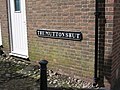 The Mutton Shut, Much Wenlock - geograph.org.uk - 153346.jpg 640 × 480; 111 KB
-
 The Quintain, Offham, Kent - geograph.org.uk - 144346.jpg 640 × 480; 79 KB
-
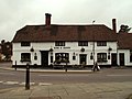
 The Street, Redgrave, Suffolk - geograph.org.uk - 226326.jpg 640 × 425; 87 KB
-

-

-

-
 Tiverton, weather radar - geograph.org.uk - 144390.jpg 640 × 427; 123 KB
-

-

-

-
 Vose Farm with daffodil fields - geograph.org.uk - 144359.jpg 640 × 480; 75 KB
-
 Walled Garden - geograph.org.uk - 144288.jpg 640 × 480; 106 KB
-
 War Memorial, Hunslet Cemetery - geograph.org.uk - 144276.jpg 464 × 640; 121 KB
-
 Water cascade, West Malling, Kent - geograph.org.uk - 144366.jpg 640 × 480; 98 KB
-
-
 Waterloo Beach - geograph.org.uk - 144277.jpg 640 × 480; 98 KB
-
 Waterloo Beach - geograph.org.uk - 144279.jpg 640 × 480; 89 KB
-
 Weir and Weetabix - geograph.org.uk - 144323.jpg 640 × 480; 156 KB
-
 WEST GRINSTEAD. PARK "STEWS POND" - geograph.org.uk - 1080492.jpg 640 × 480; 108 KB
-
 WEST GRINSTEAD. PARK STEWS PONDS - geograph.org.uk - 1080478.jpg 640 × 480; 85 KB
-
 West Malling, Kent - geograph.org.uk - 144826.jpg 640 × 480; 91 KB
-
 Woburn's Swans - geograph.org.uk - 144536.jpg 493 × 640; 83 KB
-
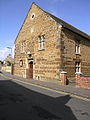
 Yeoman's Hall, East Malling, Kent - geograph.org.uk - 145726.jpg 640 × 480; 76 KB
-
 A48 , North of Lydney - geograph.org.uk - 144222.jpg 640 × 480; 96 KB
-
 Abhuinn Torra-mhichaig - geograph.org.uk - 144244.jpg 640 × 480; 108 KB
-
 Acurrach - geograph.org.uk - 151744.jpg 640 × 448; 79 KB
-
 Allt Mhic Leanain - geograph.org.uk - 144258.jpg 640 × 480; 161 KB
-
 Allt Mhic Mhoirein - geograph.org.uk - 144242.jpg 640 × 480; 113 KB
-
 Ashby Pastures near Gaddesby - geograph.org.uk - 144465.jpg 640 × 427; 113 KB
-
 At the top of Bran Hills - geograph.org.uk - 144455.jpg 640 × 480; 192 KB
-
 Baggrave Lane near Barsby - geograph.org.uk - 144818.jpg 640 × 427; 157 KB
-
 Baker's Lane at the top of Salter's Hill - geograph.org.uk - 144488.jpg 640 × 427; 123 KB
-
 Baker's Lane, Thorpe Satchville - geograph.org.uk - 144489.jpg 640 × 427; 186 KB
-
 Barn and A14 - geograph.org.uk - 144294.jpg 640 × 480; 98 KB
-
 Beach on Broadford Bay - geograph.org.uk - 144273.jpg 640 × 480; 100 KB
-
 Beck at New Miller Dam Country Park. - geograph.org.uk - 144201.jpg 640 × 480; 150 KB
-
 Below Tom an Aighe - geograph.org.uk - 151740.jpg 640 × 480; 97 KB
-
 Bluebell Wood - geograph.org.uk - 430485.jpg 640 × 480; 168 KB
-
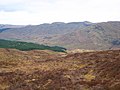
 Bogs, Glen Aray - geograph.org.uk - 151044.jpg 640 × 480; 74 KB
-
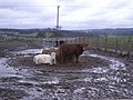 Cattle and mud - geograph.org.uk - 148799.jpg 640 × 480; 130 KB
-
 Chippenham Truckstop - geograph.org.uk - 144579.jpg 640 × 427; 45 KB
-
 Coire Mor Track - geograph.org.uk - 144253.jpg 640 × 480; 101 KB
-
 Cookson Terrace, Lydney - geograph.org.uk - 144229.jpg 640 × 480; 98 KB
-
 Countryside at Ashby Folville - geograph.org.uk - 144528.jpg 640 × 427; 146 KB
-
 Countryside near Ashby Folville - geograph.org.uk - 144524.jpg 640 × 427; 113 KB
-
 Countryside near Twyford - geograph.org.uk - 144800.jpg 640 × 427; 132 KB
-
 Darley Road. - geograph.org.uk - 144426.jpg 640 × 481; 87 KB
-
 Deppers Bridge Farm - geograph.org.uk - 144319.jpg 640 × 480; 279 KB
-
 Druim Dubh. - geograph.org.uk - 151069.jpg 640 × 480; 99 KB
-
 Easi-edge safety barriers. - geograph.org.uk - 540015.jpg 640 × 480; 180 KB
-
 Elma Lane, Holbeck - geograph.org.uk - 144203.jpg 640 × 425; 58 KB
-
 Elms Cottage, Gaddesby Lane - geograph.org.uk - 144457.jpg 640 × 427; 96 KB
-
 Farmland near Thorpe Satchville - geograph.org.uk - 144492.jpg 640 × 427; 124 KB
-
 Farmland on Thorpe Satchville Lane - geograph.org.uk - 144474.jpg 640 × 480; 134 KB
-
 Footpath through Kings Wood. - geograph.org.uk - 144199.jpg 640 × 480; 132 KB
-
 Footpath to Broadford - geograph.org.uk - 144265.jpg 640 × 480; 107 KB
-
 Forestry at Broadford - geograph.org.uk - 144270.jpg 640 × 480; 129 KB
-
 Forge End, Lower Soudley - geograph.org.uk - 144216.jpg 640 × 480; 168 KB
-
 From Clatworthy Dam. - geograph.org.uk - 144188.jpg 640 × 480; 103 KB
-
 Glen Aray - geograph.org.uk - 151080.jpg 640 × 480; 64 KB
-
 Gorge of the Allt Darach - geograph.org.uk - 144254.jpg 640 × 480; 112 KB
-
 Harewood Moor. - geograph.org.uk - 144404.jpg 640 × 481; 94 KB
-
 Hill Crest Farm, near Kirby Bellars - geograph.org.uk - 144471.jpg 640 × 427; 157 KB
-
 Information sign - geograph.org.uk - 144530.jpg 640 × 459; 123 KB
-
 Keep Left^ - geograph.org.uk - 144576.jpg 640 × 480; 30 KB
-
 Klondyke Lane near Thorpe Satchville - geograph.org.uk - 144482.jpg 640 × 427; 156 KB
-
 Ladbroke - geograph.org.uk - 144311.jpg 640 × 480; 330 KB
-
 Lane near Holbeck Woodhouse - geograph.org.uk - 144213.jpg 640 × 425; 75 KB
-

-
 Little Walton - geograph.org.uk - 144322.jpg 640 × 480; 114 KB
-
 Little Walton - geograph.org.uk - 144777.jpg 640 × 480; 150 KB
-
 Looking North nr Brain's Green - geograph.org.uk - 144217.jpg 640 × 468; 126 KB
-
 Lower Farm, Cameley, Somerset - geograph.org.uk - 146619.jpg 640 × 481; 129 KB
-
 Lutterworth - geograph.org.uk - 144300.jpg 640 × 480; 64 KB
-
 Lutterworth - geograph.org.uk - 144310.jpg 640 × 480; 130 KB
-
 Lutterworth - geograph.org.uk - 144313.jpg 640 × 480; 136 KB
-
 Lutterworth - Moorbarns Lane - geograph.org.uk - 144292.jpg 640 × 480; 110 KB
-

-
 Lydeard St Lawrence, cottage and chapel - geograph.org.uk - 144371.jpg 640 × 427; 192 KB
-
 Lydeard St Lawrence, Dyer's Barn - geograph.org.uk - 144368.jpg 640 × 427; 106 KB
-
 Lydeard St Lawrence, house at Higher Tarr - geograph.org.uk - 144365.jpg 640 × 427; 151 KB
-
 Lydeard St Lawrence, Lower Tarr - geograph.org.uk - 144370.jpg 640 × 427; 111 KB
-
 Lydeard St Lawrence, west from White Hill - geograph.org.uk - 144362.jpg 640 × 427; 151 KB
-

-
 Main Gates Lodge - geograph.org.uk - 144211.jpg 640 × 382; 72 KB
-
 Maol Accurrach - geograph.org.uk - 151742.jpg 640 × 480; 90 KB


_-_geograph.org.uk_-_144235.jpg)


Mar2006.jpg)


_-_geograph.org.uk_-_144472.jpg)


_-_geograph.org.uk_-_144461.jpg)


