Category:United Kingdom photographs taken on 2006-11-08
Countries of Europe: Austria · Belgium · Czech Republic · France‡ · Germany · Greece · Hungary · Republic of Ireland · Italy · Netherlands‡ · Poland · Portugal‡ · Russia‡ · Spain‡ · Sweden · Switzerland · Ukraine · United Kingdom
‡: partly located in Europe
‡: partly located in Europe
| ← | 8 November 2006 | → | ||
| ← | November 2006 | → | ||

United Kingdom photographs taken on 8 November 2006.
Image files should be categorized here automatically using {{taken on}} template. Direct categorisation is also possible, if automatic is impossible.
Media in category "United Kingdom photographs taken on 2006-11-08"
The following 200 files are in this category, out of 230 total.
(previous page) (next page)-
 A Grand Old Oak - geograph.org.uk - 276417.jpg 640 × 480; 97 KB
-
 A horse- drawn Grubber at Woodside farm. - geograph.org.uk - 275267.jpg 640 × 426; 206 KB
-
 A pheasant feeder by the Feddan burn. - geograph.org.uk - 275254.jpg 640 × 429; 171 KB
-

-
 A whin-clad knoll south of Hardmuir Wood. - geograph.org.uk - 275242.jpg 640 × 426; 133 KB
-
 All Saints Church, Shotesham - geograph.org.uk - 275517.jpg 640 × 480; 64 KB
-
 Alsager Centre - geograph.org.uk - 275369.jpg 640 × 427; 61 KB
-
 Arger Fen - geograph.org.uk - 275306.jpg 480 × 640; 141 KB
-
 Arger Fen - retained deadwood - geograph.org.uk - 275315.jpg 480 × 640; 136 KB
-
 Autumn In Spango Valley - geograph.org.uk - 275606.jpg 640 × 480; 121 KB
-
 Ballumbie Castle - geograph.org.uk - 840937.jpg 640 × 427; 72 KB
-
 Ballumbie Castle - geograph.org.uk - 840948.jpg 640 × 427; 126 KB
-
 Ballumbie Castle - geograph.org.uk - 841196.jpg 640 × 427; 77 KB
-
 Ballumbie Castle - geograph.org.uk - 843151.jpg 640 × 427; 122 KB
-
 Ballumbie Castle.jpg 640 × 427; 74 KB
-
 Bank Corner - geograph.org.uk - 275371.jpg 640 × 427; 94 KB
-
 Barlaston Green - geograph.org.uk - 275903.jpg 640 × 480; 102 KB
-
 Barlaston railway station 1.jpg 640 × 480; 104 KB
-
 Barn by Catstone Wood - geograph.org.uk - 276001.jpg 640 × 480; 93 KB
-

-
 Chapel Lane - geograph.org.uk - 275324.jpg 640 × 483; 122 KB
-
 Newport - geograph.org.uk - 275323.jpg 640 × 454; 121 KB
-
 Black Country Museum - geograph.org.uk - 1213382.jpg 640 × 480; 89 KB
-
 Blackburn - geograph.org.uk - 275402.jpg 640 × 480; 85 KB
-
 Blackwall Tunnel Northbound - geograph.org.uk - 275322.jpg 640 × 480; 54 KB
-
 Brickendon Grange - geograph.org.uk - 275214.jpg 640 × 428; 140 KB
-
 Bridge near Ballyroney - geograph.org.uk - 275499.jpg 640 × 426; 132 KB
-

-
 Bridleway to Swarcliffe - geograph.org.uk - 275405.jpg 640 × 480; 146 KB
-
 Bridleway, Moke Hill - geograph.org.uk - 275409.jpg 640 × 480; 154 KB
-
 Brookmount Road, Omagh - geograph.org.uk - 275274.jpg 640 × 479; 47 KB
-
 Burghead Bay near Findhorn - geograph.org.uk - 276171.jpg 640 × 427; 85 KB
-
 Burghead Bay near Findhorn - geograph.org.uk - 276175.jpg 640 × 427; 82 KB
-
 Burghead Bay near Findhorn - geograph.org.uk - 276177.jpg 640 × 427; 82 KB
-
 Chalkney Mill - geograph.org.uk - 275319.jpg 640 × 472; 114 KB
-
 Chalkney wood - main ride - geograph.org.uk - 275321.jpg 640 × 480; 161 KB
-
 Checkley - Checkley Hall - geograph.org.uk - 275761.jpg 640 × 480; 235 KB
-
 Church hall - geograph.org.uk - 276152.jpg 640 × 480; 97 KB
-
 Conistone Dib - geograph.org.uk - 279812.jpg 480 × 640; 109 KB
-
 Cotes Heath - geograph.org.uk - 275914.jpg 640 × 480; 86 KB
-
 Country road near Shelley - geograph.org.uk - 275427.jpg 640 × 418; 62 KB
-
 Countryside around Manor House Farm - geograph.org.uk - 275417.jpg 640 × 480; 79 KB
-
 Cranes - geograph.org.uk - 275341.jpg 640 × 480; 115 KB
-
 Cut Throat Lane - geograph.org.uk - 276428.jpg 640 × 480; 81 KB
-
 Darley - geograph.org.uk - 275327.jpg 640 × 480; 67 KB
-
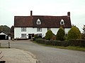
 Dinmore House - geograph.org.uk - 276410.jpg 640 × 480; 86 KB
-
 Duck pond in Crachies Wood. - geograph.org.uk - 275230.jpg 640 × 426; 167 KB
-
 Durham Cathedral - geograph.org.uk - 448187.jpg 640 × 480; 129 KB
-
 Durham cathedral interior - geograph.org.uk - 448191.jpg 640 × 480; 141 KB
-
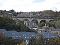 Durham railway viaduct - geograph.org.uk - 448182.jpg 640 × 480; 135 KB
-
 East Langton Grange Driveway - geograph.org.uk - 279593.jpg 640 × 480; 142 KB
-

-
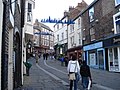 Elvet Bridge street scene - geograph.org.uk - 448196.jpg 640 × 480; 150 KB
-
 Exeter city wall at night - geograph.org.uk - 277318.jpg 640 × 480; 94 KB
-
 Falmouth - geograph.org.uk - 275426.jpg 640 × 427; 68 KB
-
 Falmouth - geograph.org.uk - 275500.jpg 640 × 427; 51 KB
-
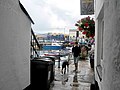 Falmouth Alleyway - geograph.org.uk - 275451.jpg 640 × 480; 69 KB
-
 Farm on Cut Throat Lane - geograph.org.uk - 275544.jpg 640 × 480; 61 KB
-
 Farmhouse at Lower Farm - geograph.org.uk - 275569.jpg 640 × 480; 59 KB
-
 Farmhouse at Shelley Priory Farm - geograph.org.uk - 275431.jpg 640 × 426; 64 KB
-
 Farmland - geograph.org.uk - 275504.jpg 640 × 480; 53 KB
-
 Fenella beach, Peel, Isle of Man - geograph.org.uk - 275232.jpg 640 × 480; 80 KB
-
 Field off Brookmount Road, Omagh - geograph.org.uk - 275170.jpg 640 × 285; 38 KB
-
 Fields near Winsley Grange - geograph.org.uk - 276943.jpg 640 × 480; 128 KB
-
 Footbridge over the River Font. - geograph.org.uk - 275425.jpg 600 × 450; 169 KB
-
 Footpath beside Catstone Wood - geograph.org.uk - 276415.jpg 640 × 480; 167 KB
-
 Footpath by Woodfield Farm - geograph.org.uk - 275550.jpg 640 × 480; 94 KB
-
 Footpath near Trustee Wood - geograph.org.uk - 276424.jpg 640 × 480; 77 KB
-
 Footpath through Donisthorpe Country Park, Leicestershire.jpg 640 × 480; 78 KB
-
 Gin gang 004.jpg 640 × 323; 69 KB
-
 Grounds off Brookmount Road, Omagh - geograph.org.uk - 275182.jpg 640 × 479; 73 KB
-
 Hanley stoke on trent city centre.jpg 640 × 427; 100 KB
-
 Heath Farm - geograph.org.uk - 275910.jpg 640 × 480; 88 KB
-
 High Eppage Wood - geograph.org.uk - 275993.jpg 640 × 480; 68 KB
-
 High Farm - geograph.org.uk - 275535.jpg 640 × 480; 103 KB
-
 High Hollins - geograph.org.uk - 275548.jpg 640 × 480; 89 KB
-
 High Street, Rye - geograph.org.uk - 905879.jpg 640 × 476; 109 KB
-
 Island Line train in London Transport livery (298251835).jpg 2,560 × 1,920; 694 KB
-
 Island Line train leaving Ryde Esplanade (298252116).jpg 2,560 × 1,920; 602 KB
-
 Island Line train on Ryde Pier (298252802).jpg 2,560 × 1,920; 399 KB
-
 Kidsgrove.jpg 640 × 407; 65 KB
-
 Kings Bromley - geograph.org.uk - 275582.jpg 640 × 427; 50 KB
-
 Kings Bromley - geograph.org.uk - 275585.jpg 640 × 427; 49 KB
-
 Lakeside Tavern - geograph.org.uk - 275893.jpg 640 × 480; 127 KB
-
 Lane north of Park House - geograph.org.uk - 276925.jpg 640 × 480; 91 KB
-
 Leek - geograph.org.uk - 275579.jpg 640 × 424; 53 KB
-

-
 Long Lane, Stoke Holy Cross - geograph.org.uk - 275595.jpg 640 × 480; 119 KB
-
 M6 Motorway - geograph.org.uk - 275907.jpg 640 × 480; 69 KB
-
 Manning's Farm - geograph.org.uk - 275496.jpg 640 × 480; 81 KB
-
 Monks Wall - geograph.org.uk - 276936.jpg 640 × 480; 121 KB
-
 Neap or Swede Slicer. - geograph.org.uk - 275265.jpg 640 × 426; 240 KB
-
 New Roundabout On A8 At Port Glasgow - geograph.org.uk - 275591.jpg 640 × 480; 67 KB
-
 Newton Mill - geograph.org.uk - 275344.jpg 640 × 185; 36 KB
-
 Next, Exeter - geograph.org.uk - 279268.jpg 480 × 640; 68 KB
-
 North of England Mules - geograph.org.uk - 277237.jpg 640 × 467; 90 KB
-
 Nunriding Hall - geograph.org.uk - 275356.jpg 600 × 450; 77 KB
-
 Oaks Park High School - geograph.org.uk - 275197.jpg 640 × 480; 63 KB
-
 Old Crab and Winkle line - geograph.org.uk - 275507.jpg 480 × 640; 177 KB
-
 Old signpost with Grid Reference - geograph.org.uk - 279807.jpg 640 × 480; 129 KB
-
 Pendre Inn, Abergwaun-Fishguard - geograph.org.uk - 276106.jpg 640 × 427; 59 KB
-
 Pond, Shotesham Common - geograph.org.uk - 275590.jpg 640 × 480; 80 KB
-
 Potteries photo.jpg 640 × 427; 81 KB
-
 Powney Street, Milden, Suffolk - geograph.org.uk - 275547.jpg 640 × 480; 76 KB
-
 Pylon in farmland near Buckshaw - geograph.org.uk - 275419.jpg 600 × 450; 113 KB
-
 Railway tunnel - geograph.org.uk - 275455.jpg 640 × 480; 178 KB
-

-
 Riva Hill House Farm - geograph.org.uk - 275991.jpg 640 × 480; 76 KB
-
 River avon - geograph.org.uk - 276139.jpg 640 × 480; 89 KB
-
 Road - geograph.org.uk - 275460.jpg 640 × 424; 36 KB
-
 Road between Darley and Birstwith - geograph.org.uk - 275394.jpg 640 × 480; 86 KB
-
 Saltford churchyard - geograph.org.uk - 276115.jpg 640 × 480; 83 KB
-
 Saltford Library - geograph.org.uk - 276149.jpg 640 × 480; 80 KB
-
 Saltford school - geograph.org.uk - 276085.jpg 640 × 480; 78 KB
-
 Saltford`s vet - geograph.org.uk - 276164.jpg 480 × 640; 63 KB
-
 Scripcross Bridge - geograph.org.uk - 275560.jpg 640 × 480; 79 KB
-
 Shaggy Ink Cap or Coprinus comatus. - geograph.org.uk - 275259.jpg 640 × 426; 122 KB
-
 Shapbeck Bridge - geograph.org.uk - 598958.jpg 640 × 368; 68 KB
-
 Sheep grazing, Stoke Holy Cross - geograph.org.uk - 275479.jpg 640 × 480; 77 KB
-
 South Farm - geograph.org.uk - 275985.jpg 640 × 480; 69 KB
-
 Spires Shopping Centre.jpg 1,200 × 1,136; 189 KB
-
 Spring House Wood - geograph.org.uk - 275998.jpg 640 × 480; 127 KB
-

-

-
 St Peter's Church Langton - geograph.org.uk - 279954.jpg 628 × 640; 104 KB
-
 Strule Park, Omagh - geograph.org.uk - 275276.jpg 640 × 479; 57 KB
-
 Strule Park, Omagh - geograph.org.uk - 275277.jpg 640 × 279; 31 KB
-
 Strule Park, Omagh - geograph.org.uk - 275278.jpg 640 × 479; 45 KB
-
 Strule Park, Omagh - geograph.org.uk - 275279.jpg 640 × 268; 31 KB
-
 Strule Park, Omagh - geograph.org.uk - 275280.jpg 640 × 297; 26 KB
-
 Summerfield Court, Omagh - geograph.org.uk - 275270.jpg 640 × 479; 45 KB
-
 Summerhill Court, Omagh - geograph.org.uk - 275269.jpg 640 × 304; 29 KB
-
 Swan Street, Boxford, Suffolk - geograph.org.uk - 275581.jpg 640 × 480; 63 KB
-
 Tetbury St Saviours New Church Street - geograph.org.uk - 275225.jpg 640 × 480; 54 KB
-
 The Ford - geograph.org.uk - 275295.jpg 640 × 480; 179 KB
-
 The Globe, Shotesham - geograph.org.uk - 275568.jpg 640 × 480; 89 KB
-
 The Potato Digger of days gone by. - geograph.org.uk - 275281.jpg 640 × 426; 205 KB
-
 The Reaper at Woodside Farm. - geograph.org.uk - 275272.jpg 640 × 426; 150 KB
-
 The richness of the boglands. - geograph.org.uk - 275262.jpg 640 × 426; 112 KB
-
 The River Bann near Ballyroney (1) - geograph.org.uk - 275448.jpg 640 × 426; 153 KB
-
 The River Bann near Ballyroney (2) - geograph.org.uk - 275489.jpg 640 × 426; 161 KB
-
 Tower of St John's Church at Donisthorpe, Leicestershire.jpg 640 × 480; 151 KB
-
 Town Street, Shaw Mills - geograph.org.uk - 276420.jpg 640 × 480; 65 KB
-
 Trent and Mersey Canal, Barlaston - geograph.org.uk - 275901.jpg 480 × 640; 109 KB
-

-
 Trustee Wood - geograph.org.uk - 275542.jpg 640 × 480; 90 KB
-
 Upper Park Street - geograph.org.uk - 277646.jpg 640 × 480; 41 KB
-
 V for...^ - geograph.org.uk - 378054.jpg 640 × 426; 105 KB
-
 Water Tower, standing by Holt Road - geograph.org.uk - 275487.jpg 640 × 460; 48 KB
-
 Well Dressing - geograph.org.uk - 275412.jpg 640 × 480; 139 KB
-
 Wendy House - geograph.org.uk - 275603.jpg 640 × 480; 66 KB
-
 Wheelie bins on New Street, Donisthorpe, Leicestershire.jpg 640 × 480; 100 KB
-

-
 White Hart Inn, Exeter - geograph.org.uk - 279265.jpg 480 × 640; 111 KB
-
 Woods near Winsley Hall Farm - geograph.org.uk - 275538.jpg 640 × 480; 69 KB
-
 Woods on Whipley Moor - geograph.org.uk - 276002.jpg 640 × 480; 133 KB
-
-
 Yetholm Loch - geograph.org.uk - 277496.jpg 640 × 483; 91 KB
-
 Yetholm Loch - geograph.org.uk - 277501.jpg 640 × 447; 66 KB
-
 A junction on Millwood Road - geograph.org.uk - 275447.jpg 640 × 439; 75 KB
-
 Animal Pens - geograph.org.uk - 279947.jpg 640 × 480; 84 KB
-
 Ardersier - geograph.org.uk - 1019135.jpg 640 × 480; 62 KB
-
 Ashby Canal (Donisthorpe Terminus) - geograph.org.uk - 275132.jpg 640 × 480; 95 KB
-
 B6047 towards Melton Mowbray - geograph.org.uk - 279591.jpg 640 × 468; 64 KB
-
 Biddulph - geograph.org.uk - 275385.jpg 640 × 427; 77 KB
-
 Big Shed - geograph.org.uk - 279953.jpg 640 × 480; 56 KB
-
 Bigney Hill, peaceful now - geograph.org.uk - 276107.jpg 640 × 409; 120 KB
-
 Bridgemere - valley of Forge Brook - geograph.org.uk - 275744.jpg 640 × 480; 187 KB
-
 Bridleway from Buckshaw to Throphill Farm - geograph.org.uk - 275428.jpg 600 × 450; 152 KB
-

-
 Buckshaw Farm - geograph.org.uk - 275422.jpg 600 × 450; 105 KB
-
 Cattle - geograph.org.uk - 275430.jpg 640 × 424; 61 KB
-
 Checkley - Checkley Wood New Farm - geograph.org.uk - 275750.jpg 640 × 480; 125 KB
-
 Checkley - Mallard House on Checkley Lane - geograph.org.uk - 275763.jpg 640 × 480; 206 KB
-
 Checkley - near Checkley Wood Farm - geograph.org.uk - 275748.jpg 640 × 480; 133 KB
-
 Checkley - The Grange - geograph.org.uk - 275754.jpg 639 × 480; 149 KB
-
 Checkley - view towards Checkley Wood - geograph.org.uk - 275759.jpg 640 × 480; 109 KB
-
 Church Causeway - geograph.org.uk - 279960.jpg 640 × 480; 127 KB
-
 Conversion plans - geograph.org.uk - 279957.jpg 326 × 640; 60 KB
-
 Cottages on Church Lane - geograph.org.uk - 279959.jpg 640 × 540; 114 KB
-
 Cows grazing in early morning mist - geograph.org.uk - 278638.jpg 640 × 480; 127 KB
-
 Derby - geograph.org.uk - 275354.jpg 640 × 427; 54 KB
-
 Falmouth Centre - geograph.org.uk - 275432.jpg 640 × 427; 76 KB
-
 Farmhouse at Bridge Farm - geograph.org.uk - 275553.jpg 640 × 480; 77 KB
-
 Farmhouse at Hays Farm - geograph.org.uk - 275512.jpg 640 × 375; 63 KB
-
 Farmhouse at Holton Place - geograph.org.uk - 275370.jpg 640 × 480; 98 KB
-
 Farmland - geograph.org.uk - 275420.jpg 640 × 424; 44 KB
-
 Field at Tamlaght Road, Omagh - geograph.org.uk - 275176.jpg 640 × 479; 72 KB
-
 Field at Tamlaght Road, Omagh - geograph.org.uk - 275177.jpg 640 × 479; 76 KB
-
 Field at Tamlaght Road, Omagh - geograph.org.uk - 275180.jpg 640 × 479; 75 KB
-
 Field at Tamlaght Road, Omagh - geograph.org.uk - 275181.jpg 640 × 295; 39 KB
-
 Field looking towards Tyler Hill - geograph.org.uk - 276270.jpg 640 × 480; 144 KB
-
 Footbridge - geograph.org.uk - 275655.jpg 640 × 424; 84 KB
-

-
 From Bryansford to Hilltown - geograph.org.uk - 278016.jpg 640 × 426; 134 KB
-
 Hadleigh Road at Higham, Suffolk - geograph.org.uk - 275390.jpg 640 × 480; 101 KB
-
 High Pressure Gas^ - geograph.org.uk - 279951.jpg 480 × 640; 169 KB
-
 Ipswich - geograph.org.uk - 275526.jpg 640 × 427; 48 KB
-
 Ipswich Marina - geograph.org.uk - 275531.jpg 640 × 427; 53 KB
-
 Kilnsey in Wharfedale - geograph.org.uk - 279799.jpg 640 × 480; 106 KB


_-_geograph.org.uk_-_275506.jpg)


.jpg)
.jpg)


_-_geograph.org.uk_-_275448.jpg)
_-_geograph.org.uk_-_275489.jpg)


_-_geograph.org.uk_-_278564.jpg)


_-_geograph.org.uk_-_275132.jpg)


.jpg)