Category:United Kingdom photographs taken on 2007-07-09
Countries of Europe: Armenia‡ · Austria · Belarus · Belgium · Bosnia and Herzegovina · Finland · France‡ · Germany · Greece · Hungary · Italy · Latvia · Netherlands‡ · Norway · Poland · Portugal‡ · Russia‡ · Serbia · Spain‡ · Sweden · Turkey‡ · Ukraine · United Kingdom · Vatican City
Specific status: Isle of Man
‡: partly located in Europe
Specific status: Isle of Man
‡: partly located in Europe
| ← | 9 July 2007 | → | ||
| ← | July 2007 | → | ||

United Kingdom photographs taken on 9 July 2007.
Image files should be categorized here automatically using {{taken on}} template. Direct categorisation is also possible, if automatic is impossible.
Subcategories
This category has only the following subcategory.
S
Media in category "United Kingdom photographs taken on 2007-07-09"
The following 200 files are in this category, out of 709 total.
(previous page) (next page)-
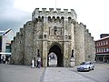 "Bargate", Southampton - geograph.org.uk - 495410.jpg 640 × 480; 227 KB
-
 "Nationwide" on the - geograph.org.uk - 495388.jpg 480 × 640; 150 KB
-

-
 "The Kitchen" - geograph.org.uk - 490205.jpg 640 × 480; 72 KB
-
 'Emerald Gratia' approaching Bangor - geograph.org.uk - 491571.jpg 640 × 325; 41 KB
-
 (Part of) Townfoot, Slaley - geograph.org.uk - 499107.jpg 640 × 480; 122 KB
-
 15 Wildwood Road - geograph.org.uk - 494122.jpg 640 × 480; 173 KB
-
 18th Century 'Improvement Farm' - geograph.org.uk - 500768.jpg 640 × 437; 65 KB
-
 455732 D M Cl 508 TSO Interior 1.JPG 1,998 × 1,535; 963 KB
-
 455732 D MSO Interior 1.JPG 2,017 × 1,535; 1,016 KB
-
 455732 D MSO Interior.JPG 2,019 × 1,535; 1.07 MB
-
 455857 D M DTSO Interior 1.JPG 1,806 × 1,535; 915 KB
-
 455857 D M MSO Interior.JPG 2,048 × 1,536; 863 KB
-
 458015 A First Class Interior.JPG 2,048 × 1,536; 855 KB
-
 458015 A Standard Class Interior.JPG 1,952 × 1,467; 994 KB
-
 483004 Interior.JPG 2,048 × 1,332; 1.14 MB
-
 483004 Shanklin 1.JPG 2,048 × 1,536; 1,000 KB
-
 483004 Shanklin Interior.JPG 2,048 × 1,536; 1.1 MB
-
 483008 Ryde Pier Head.JPG 1,511 × 1,149; 389 KB
-
 A new angle on Barmouth - geograph.org.uk - 667235.jpg 427 × 640; 49 KB
-

-
 A track into Bin Forest - geograph.org.uk - 490542.jpg 480 × 640; 117 KB
-

-
 Abbey Street - geograph.org.uk - 489965.jpg 640 × 480; 81 KB
-
 Above Bar Street, Southampton - geograph.org.uk - 495367.jpg 640 × 480; 209 KB
-
 Aboyne Castle estate wall - geograph.org.uk - 490310.jpg 546 × 420; 93 KB
-
 Across the Millpond - geograph.org.uk - 501123.jpg 640 × 480; 81 KB
-
-
 All Saints Church, Rudston - Churchyard - geograph.org.uk - 505821.jpg 640 × 480; 134 KB
-
-
 All Saints Church, Rudston - Door - geograph.org.uk - 505867.jpg 477 × 640; 104 KB
-
 All Saints Church, Rudston - Font - geograph.org.uk - 505839.jpg 480 × 640; 44 KB
-
 All Saints Church, Rudston - geograph.org.uk - 505862.jpg 640 × 448; 79 KB
-
 All Saints Church, Rudston - Interior - geograph.org.uk - 505847.jpg 640 × 480; 72 KB
-
 All Saints Church, Rudston - Interior - geograph.org.uk - 505850.jpg 640 × 480; 84 KB
-
 All Saints Church, Rudston - Label Stop - geograph.org.uk - 505834.jpg 640 × 480; 117 KB
-
 All Saints Church, Rudston - Label Stop - geograph.org.uk - 505835.jpg 640 × 480; 123 KB
-
 All Saints Church, Rudston - Porch - geograph.org.uk - 506528.jpg 480 × 640; 93 KB
-
 Arable land and woods near Hirst Hill - geograph.org.uk - 498790.jpg 640 × 480; 96 KB
-
 Arable land and woods near Linnel Hill - geograph.org.uk - 498795.jpg 640 × 480; 111 KB
-
 Arable land, hill 150 and Wooley Wood - geograph.org.uk - 490293.jpg 640 × 480; 100 KB
-
 Arch, Selwicks Bay - geograph.org.uk - 507457.jpg 640 × 480; 134 KB
-
 Arrival of the "Mare Gratia" - geograph.org.uk - 490855.jpg 636 × 422; 319 KB
-
 Ashfield Road, Rochdale, Lancashire - geograph.org.uk - 496346.jpg 640 × 427; 85 KB
-
 Asloun Castle - geograph.org.uk - 494936.jpg 640 × 480; 117 KB
-
 Bacup, Lancashire, Methodist Free Church - geograph.org.uk - 1749964.jpg 1,600 × 2,290; 2.18 MB
-
 Baling hay on Palm Strothers Farm - geograph.org.uk - 498897.jpg 640 × 480; 88 KB
-
 Barley Field - geograph.org.uk - 490702.jpg 640 × 480; 97 KB
-
 Barley Fields Near Towhaugh - geograph.org.uk - 491763.jpg 640 × 480; 65 KB
-

-
 Beach Huts, North Sands, Bridlington - geograph.org.uk - 506629.jpg 640 × 480; 104 KB
-
 Beacon, Flamborough Head - geograph.org.uk - 507483.jpg 640 × 480; 43 KB
-
 BeaufortTheatre.jpg 615 × 344; 148 KB
-
 Berneray Beach Harris 2.jpg 640 × 480; 45 KB
-
 Berneray Beach Harris.jpg 640 × 359; 48 KB
-
 Berneray Beach Pabbay 1.jpg 640 × 480; 56 KB
-
 Berneray Forecasting Stone.jpg 640 × 480; 109 KB
-
 Berneray Houses North Uist.jpg 640 × 480; 70 KB
-
 Berneray North Uist Rubha Bhoisnis Boat.jpg 640 × 359; 61 KB
-
 Berneray Rubha Bhoisnis North Uist.jpg 640 × 480; 97 KB
-
 Berneray Rubha Bhoisnis.jpg 640 × 359; 64 KB
-
 Berneray Sheeps.jpg 640 × 359; 59 KB
-
 Berneray Shop.jpg 640 × 480; 78 KB
-
 Boat in Bridlington Harbour - geograph.org.uk - 506611.jpg 480 × 640; 80 KB
-
-
 Boats moored at Bridlington Harbour - geograph.org.uk - 506617.jpg 640 × 480; 80 KB
-
 Bolton-on-Swale Lake - geograph.org.uk - 492073.jpg 640 × 427; 313 KB
-
 Boundary stone used as OS benchmark - geograph.org.uk - 490989.jpg 640 × 480; 156 KB
-
 Boundary wall - geograph.org.uk - 490386.jpg 640 × 480; 113 KB
-
 Boynton Village Hall.jpg 640 × 480; 65 KB
-
 Bradley Court, Keldregate - geograph.org.uk - 490278.jpg 640 × 480; 111 KB
-
 Bradley Court, Keldregate - geograph.org.uk - 490285.jpg 640 × 480; 127 KB
-
 Bradley Road - Curzon Street - geograph.org.uk - 490377.jpg 640 × 480; 95 KB
-
 Bradley Road, Bradley - geograph.org.uk - 490260.jpg 640 × 480; 80 KB
-
 Bramley Lane, Hipperholme - geograph.org.uk - 492135.jpg 640 × 437; 78 KB
-
 The 'Bridge Inn', Rochdale - geograph.org.uk - 496720.jpg 640 × 427; 89 KB
-
 Bridleway - geograph.org.uk - 489689.jpg 640 × 480; 146 KB
-
 Bridleway from Boynton to Carnaby - geograph.org.uk - 506552.jpg 640 × 480; 125 KB
-
 Bridlington Harbour - geograph.org.uk - 506588.jpg 640 × 480; 82 KB
-
 Bridlington Harbour - geograph.org.uk - 506594.jpg 640 × 480; 83 KB
-
 Bridlington Harbour - geograph.org.uk - 506597.jpg 640 × 407; 55 KB
-
 Bridlington Harbour - geograph.org.uk - 506625.jpg 640 × 480; 82 KB
-
 Bristol VR ECW caravan bus in Hampstead Heath, London 9 July 2007.jpg 640 × 480; 129 KB
-
 Broomholm Priory - geograph.org.uk - 489970.jpg 640 × 480; 57 KB
-

-
 BT tower - geograph.org.uk - 778943.jpg 640 × 480; 89 KB
-
 Burnley Hall - geograph.org.uk - 489981.jpg 640 × 480; 85 KB
-
 Burnley Road, Bacup, Lancashire - geograph.org.uk - 496935.jpg 640 × 427; 82 KB
-
 Bus shelter outside Australia - geograph.org.uk - 489399.jpg 640 × 480; 75 KB
-
 Carlton Terrace - geograph.org.uk - 490596.jpg 640 × 480; 115 KB
-
 Castell Talyfan Footpath - geograph.org.uk - 490799.jpg 640 × 480; 303 KB
-
 Castell y Bere - geograph.org.uk - 494310.jpg 640 × 480; 221 KB
-
 Cattle in a Field - geograph.org.uk - 489753.jpg 640 × 425; 123 KB
-
 Cattle in a Field - geograph.org.uk - 491751.jpg 640 × 481; 104 KB
-
 Cavendish Farm, Weston Village - geograph.org.uk - 490021.jpg 640 × 480; 87 KB
-
 Caves - geograph.org.uk - 494836.jpg 640 × 480; 167 KB
-
 Chalk Lighthouse at Flamborough Head - geograph.org.uk - 507488.jpg 640 × 480; 41 KB
-
 Chemical Works Weston Point.jpg 640 × 480; 74 KB
-
 Christchurch, Stoke Road, Gosport - geograph.org.uk - 715596.jpg 640 × 480; 73 KB
-
 Church of Holyrood, Southampton - geograph.org.uk - 495487.jpg 480 × 640; 154 KB
-
 Churchyard Wall, Rudston - geograph.org.uk - 506535.jpg 640 × 480; 101 KB
-

-
 City Hall with stormy sky - geograph.org.uk - 492838.jpg 477 × 640; 87 KB
-
 Clints crags - geograph.org.uk - 494961.jpg 614 × 461; 99 KB
-
 Clints Crags - geograph.org.uk - 494963.jpg 614 × 461; 124 KB
-
 Clunie phone box and postbox - geograph.org.uk - 489848.jpg 640 × 425; 105 KB
-
 Coastguard Station, Flamborough Head - geograph.org.uk - 507479.jpg 640 × 480; 52 KB
-
 Coley Road, Coley - geograph.org.uk - 492105.jpg 640 × 415; 63 KB
-
 Coley School, Coley Road, Lower Shelf - geograph.org.uk - 494710.jpg 640 × 468; 94 KB
-
 Copthorne Square, Keldregate - geograph.org.uk - 490294.jpg 640 × 480; 117 KB
-
 Copthorne Square, Keldregate - geograph.org.uk - 490305.jpg 640 × 480; 110 KB
-
 Copy of Eleanor Cross, Sledmere - geograph.org.uk - 501160.jpg 640 × 480; 85 KB
-
-
 Country Road South of Llansannor - geograph.org.uk - 491574.jpg 640 × 480; 322 KB
-
 Craswall - geograph.org.uk - 490454.jpg 640 × 480; 96 KB
-
 Cricket Field, Newcastle Cricket Club - geograph.org.uk - 490616.jpg 640 × 480; 91 KB
-
 Cricket Pavilion, Newcastle Cricket Club - geograph.org.uk - 490617.jpg 640 × 473; 125 KB
-
 Croft of Dykeside - geograph.org.uk - 490543.jpg 480 × 640; 85 KB
-
 Cross on Whittle Pike - geograph.org.uk - 490951.jpg 640 × 480; 60 KB
-
 Curzon Street, Bradley - geograph.org.uk - 490403.jpg 639 × 478; 86 KB
-
 Damselflies, near South Cerney - geograph.org.uk - 489790.jpg 640 × 480; 87 KB
-
 Damselfly, near South Cerney - geograph.org.uk - 489789.jpg 640 × 480; 70 KB
-
 Dancing fish on Erith Roundabout - geograph.org.uk - 491165.jpg 640 × 480; 72 KB
-

-
 Deeplish Road, Rochdale - geograph.org.uk - 496357.jpg 640 × 427; 92 KB
-
 Deeplish Road, Rochdale, Lancashire - geograph.org.uk - 496339.jpg 640 × 427; 79 KB
-
 Deighton Police Station, Keldregate - geograph.org.uk - 490328.jpg 640 × 480; 93 KB
-
 Demolished^ - geograph.org.uk - 493790.jpg 640 × 480; 104 KB
-
 Demolition site, A419 Blunsdon - geograph.org.uk - 489788.jpg 640 × 480; 130 KB
-
 Denholmegate Road, Coley - geograph.org.uk - 492011.jpg 640 × 436; 81 KB
-

-

-

-
 Dinas Cross war memorial and school - geograph.org.uk - 496153.jpg 640 × 426; 64 KB
-
 Dinas standing stone - geograph.org.uk - 489921.jpg 640 × 480; 100 KB
-
 Disused Drinking Fountain - geograph.org.uk - 493862.jpg 480 × 640; 178 KB
-
 Disused mine shaft - geograph.org.uk - 490974.jpg 640 × 480; 135 KB
-
 Dorrington Sewage Treatment Works - geograph.org.uk - 490042.jpg 640 × 480; 106 KB
-
 Dorrington Sewage Treatment Works - geograph.org.uk - 490051.jpg 640 × 480; 131 KB
-
 Old Timer - geograph.org.uk - 490035.jpg 640 × 480; 121 KB
-

-
 Eagle and Child Public House - geograph.org.uk - 1725991.jpg 640 × 474; 121 KB
-
 East Carlton Farm - geograph.org.uk - 489658.jpg 640 × 480; 139 KB
-
 St Andrew's Church, East Heslerton - geograph.org.uk - 508183.jpg 640 × 480; 97 KB
-
 St Andrew's Church, East Heslerton - geograph.org.uk - 508193.jpg 640 × 480; 99 KB
-

-
-
 Ellerton Lake - geograph.org.uk - 492078.jpg 640 × 427; 407 KB
-
 Erasmus Darwin House -herb garden-9July2007.jpg 425 × 640; 69 KB
-
 Erith, trolley graveyard - geograph.org.uk - 491178.jpg 480 × 640; 62 KB
-
 Eskdale viewed from Brotherilkeld - geograph.org.uk - 527757.jpg 640 × 426; 94 KB
-
 Excavated Farm buildings at Wharram Percy - geograph.org.uk - 500782.jpg 640 × 480; 117 KB
-
 Fallady - geograph.org.uk - 492902.jpg 640 × 427; 294 KB
-
 Farm at Brotherilkeld - geograph.org.uk - 527752.jpg 640 × 426; 105 KB
-
-
 Farmland near Palm Strothers - geograph.org.uk - 498890.jpg 640 × 480; 99 KB
-
 Fields and woods around Linnel Hill - geograph.org.uk - 498799.jpg 640 × 480; 91 KB
-
 First Glasgow bus SF07 FDP.jpg 1,024 × 768; 163 KB
-
 First Glasgow bus SJ51 DKK.jpg 1,024 × 768; 149 KB
-
 First Glasgow bus T827 LLC.jpg 1,024 × 768; 161 KB
-
 First Glasgow buses.jpg 1,024 × 768; 132 KB
-

-
 Fishing boats, Bridlington Harbour - geograph.org.uk - 506606.jpg 640 × 480; 108 KB
-
 Fitty Hill, Westside, Westray - geograph.org.uk - 489704.jpg 640 × 473; 68 KB
-
 Footbridge - geograph.org.uk - 493474.jpg 480 × 640; 126 KB
-
 Footpath through Eymore Wood - geograph.org.uk - 493446.jpg 480 × 640; 151 KB
-
 Footpath to Stocks, Shelf - geograph.org.uk - 491443.jpg 640 × 480; 138 KB
-
 Foregate Street - geograph.org.uk - 506711.jpg 640 × 480; 126 KB
-

-

-
 Foxglove glade - geograph.org.uk - 495810.jpg 640 × 480; 178 KB
-
 Foxglove near Blue Gables - geograph.org.uk - 499074.jpg 496 × 640; 76 KB
-
 Glasgow - First 37182 (SF07FDP).jpg 1,024 × 768; 159 KB
-
 Glasgow and South Western Railway No 9 at Glasgow transport museum.jpg 1,024 × 768; 119 KB
-
 Glasgow Corporation electric loco.jpg 1,024 × 768; 138 KB
-

-
 Greenhead - geograph.org.uk - 492913.jpg 640 × 427; 241 KB
-
 Hampstead Heath Extension - geograph.org.uk - 493842.jpg 480 × 640; 173 KB
-
 Hampstead Heath Extension - geograph.org.uk - 493852.jpg 480 × 640; 163 KB
-
 Harbury Fields - geograph.org.uk - 830996.jpg 640 × 457; 294 KB
-
 Hardknott Pass - geograph.org.uk - 527753.jpg 640 × 426; 116 KB
-
 Harlech Castle - geograph.org.uk - 497819.jpg 640 × 480; 206 KB
-
 Harlech Castle - The North West Tower - geograph.org.uk - 497817.jpg 640 × 480; 212 KB
-
 Hay Field - geograph.org.uk - 491202.jpg 640 × 480; 108 KB
-
 Healey Street, Rochdale, Lancashire - geograph.org.uk - 496301.jpg 640 × 427; 88 KB
-
 Helicopter in Eskdale - geograph.org.uk - 513215.jpg 640 × 426; 122 KB
-
 Herdwick sheep crossing Lingcove Bridge - geograph.org.uk - 493838.jpg 640 × 426; 145 KB
-
 High Street, Southampton - geograph.org.uk - 495383 (cropped).jpg 325 × 243; 81 KB
-
 High Street, Southampton - geograph.org.uk - 495383.jpg 640 × 480; 191 KB
-

-
 Hogston - geograph.org.uk - 490694.jpg 640 × 480; 102 KB
-

-

-

-

-
 Hotel under construction, Marsh Lane, Preston - geograph.org.uk - 1725139.jpg 1,944 × 2,592; 1.16 MB
-

-
 Houses, Bramley Lane, Hipperholme - geograph.org.uk - 494598.jpg 640 × 411; 85 KB
-

-


_Townfoot,_Slaley_-_geograph.org.uk_-_499107.jpg)


.jpg)

,_Loch_Clunie_-_geograph.org.uk_-_1505032.jpg)


.jpg)


