Category:United Kingdom photographs taken on 2007-07-18
Countries of Europe: Austria · Azerbaijan‡ · Belgium · Czech Republic · Finland · France‡ · Germany · Greece · Iceland · Republic of Ireland · Italy · Latvia · Lithuania · Netherlands‡ · Norway · Poland · Portugal‡ · Romania · Russia‡ · Slovenia · Spain‡ · Sweden · Switzerland · Ukraine · United Kingdom
‡: partly located in Europe
‡: partly located in Europe
| ← | 18 July 2007 | → | ||
| ← | July 2007 | → | ||

United Kingdom photographs taken on 18 July 2007.
Image files should be categorized here automatically using {{taken on}} template. Direct categorisation is also possible, if automatic is impossible.
Subcategories
This category has the following 3 subcategories, out of 3 total.
Media in category "United Kingdom photographs taken on 2007-07-18"
The following 200 files are in this category, out of 1,049 total.
(previous page) (next page)-
 "Hollins Bush" Hollins - geograph.org.uk - 500912.jpg 640 × 480; 155 KB
-
 "Mona Tractors" Chwilog - geograph.org.uk - 499312.jpg 640 × 428; 131 KB
-
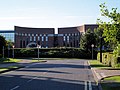
 'Art Deco' Office block from the 1980's. - geograph.org.uk - 499290.jpg 640 × 480; 140 KB
-
 'Windsor Castle' laid up at Tolverne - geograph.org.uk - 711459.jpg 640 × 480; 54 KB
-
 210 Aztec West. - geograph.org.uk - 499303 (cropped).jpg 625 × 359; 85 KB
-
 210 Aztec West. - geograph.org.uk - 499303.jpg 625 × 487; 98 KB
-

-

-

-

-
 A recent addition to the Landscape, Pysgotwr, Ceredigion - geograph.org.uk - 514710.jpg 1,600 × 1,065; 1.18 MB
-
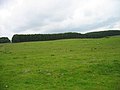
 A roofless barn in a hay meadow - geograph.org.uk - 503152.jpg 640 × 480; 80 KB
-

-
 A short cut to Llanfachreth - geograph.org.uk - 723976.jpg 602 × 640; 145 KB
-

-
 A75 At Cardoness - geograph.org.uk - 498817.jpg 640 × 480; 113 KB
-
 Abandoned friths - geograph.org.uk - 727767.jpg 640 × 421; 112 KB
-

-
 Afon Doethie Fawr, Ceredigion - geograph.org.uk - 514619.jpg 1,600 × 1,200; 2.22 MB
-
 Afon Doethie Fawr, Ceredigion - geograph.org.uk - 514624.jpg 640 × 480; 173 KB
-
 Afon Eden upstream of Pont ar Eden - geograph.org.uk - 499741.jpg 640 × 480; 173 KB
-
 Afon Pysgotwr Fawr, Ceredigion - geograph.org.uk - 508596.jpg 1,600 × 1,200; 2.06 MB
-
 Almshouses by St. Mary's church - geograph.org.uk - 504144.jpg 640 × 423; 60 KB
-

-

-

-
 Antrim Road Waterworks (1) - geograph.org.uk - 497906.jpg 640 × 480; 112 KB
-
 Antrim Road Waterworks (2) - geograph.org.uk - 497907.jpg 640 × 367; 108 KB
-
 Antrim Road Waterworks (3) - geograph.org.uk - 497909.jpg 640 × 390; 129 KB
-

-

-
 Careless parking^ - geograph.org.uk - 1231047.jpg 640 × 480; 125 KB
-
 Avon Beach Café - geograph.org.uk - 497918.jpg 640 × 414; 84 KB
-
 Avon gorge dusk.jpg 2,306 × 3,591; 1.16 MB
-
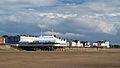
 Avon Sands Apartments - geograph.org.uk - 497913.jpg 640 × 480; 90 KB
-
 Aztec West Office Park. - geograph.org.uk - 499287.jpg 640 × 480; 106 KB
-
 B 1450 towards Ashby Decoy - geograph.org.uk - 498879.jpg 640 × 480; 78 KB
-
 B3254 near Langdon Cross - geograph.org.uk - 498477.jpg 640 × 458; 112 KB
-
 B4392 above Cyfronydd - geograph.org.uk - 500031.jpg 640 × 480; 93 KB
-
 B871 road and River Helmsdale - geograph.org.uk - 505091.jpg 640 × 480; 69 KB
-
 Ballintoy Harbour - geograph.org.uk - 646721.jpg 640 × 480; 127 KB
-
 Bank in Launceston town centre - geograph.org.uk - 503311.jpg 640 × 480; 107 KB
-
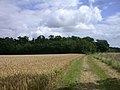
 Barley field - geograph.org.uk - 498556.jpg 640 × 480; 126 KB
-
 Barley field towards Ashby Decoy - geograph.org.uk - 498886.jpg 640 × 480; 72 KB
-
 Bath near West Dizzard - geograph.org.uk - 501333.jpg 480 × 640; 116 KB
-
 Beatrix Potter Gallery, Hawkshead - geograph.org.uk - 503308.jpg 640 × 427; 87 KB
-
 Behind the Three Old Arches - geograph.org.uk - 828821.jpg 640 × 480; 58 KB
-
 Below Craighoar - geograph.org.uk - 498544.jpg 640 × 480; 156 KB
-
 Bencoolen Road, Bude - geograph.org.uk - 503109.jpg 640 × 480; 107 KB
-
 Bennacott Methodist Church - geograph.org.uk - 498493.jpg 640 × 480; 93 KB
-

-
 Birkyburn Copse - geograph.org.uk - 498240.jpg 640 × 516; 64 KB
-
 Black o'er Jack's house - geograph.org.uk - 498173.jpg 640 × 427; 76 KB
-
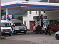 Blair Atholl Petrol Station - geograph.org.uk - 503835.jpg 640 × 480; 80 KB
-
 Blue flower, Hinton Parva combe - geograph.org.uk - 498144.jpg 640 × 480; 80 KB
-
 Boat at Millook - geograph.org.uk - 500938.jpg 640 × 457; 122 KB
-
 Bog near Cefn Golau - geograph.org.uk - 526740.jpg 640 × 480; 117 KB
-

-
 Bolter's Lane - geograph.org.uk - 530965.jpg 640 × 480; 65 KB
-
 Botany, sheep about to be shorn - geograph.org.uk - 500623.jpg 640 × 480; 109 KB
-
 Boverton, Vale of Glamorgan, UK - panoramio.jpg 1,632 × 1,224; 321 KB
-
 Bradlaugh Terrace - geograph.org.uk - 498505.jpg 640 × 500; 58 KB
-
 Bridge 65 - geograph.org.uk - 498291.jpg 640 × 480; 113 KB
-
 Bridge 66 - geograph.org.uk - 498223.jpg 640 × 480; 93 KB
-
-
 Bridge Street - geograph.org.uk - 498692.jpg 640 × 480; 91 KB
-
 Bridge Street, Coleraine - geograph.org.uk - 643754.jpg 640 × 480; 87 KB
-
-

-
 Bridleway to Coomb Grove Farm - geograph.org.uk - 834423.jpg 640 × 480; 61 KB
-
 Bridleway to Holbeins Farm - geograph.org.uk - 834428.jpg 640 × 480; 76 KB
-
 Brook through the pasture above Cyfronydd - geograph.org.uk - 498447.jpg 640 × 480; 140 KB
-
 Bryan Hey Reservoir - geograph.org.uk - 501157.jpg 640 × 480; 199 KB
-
 Burncrofts - geograph.org.uk - 498786.jpg 480 × 640; 76 KB
-
 Burnham low light geograph-498963-by-Steve--F.jpg 640 × 426; 58 KB
-
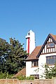 Burnham on Sea high lighthouse. - geograph.org.uk - 499308.jpg 427 × 640; 109 KB
-
 Burnham on Sea lower light499306 972f1bf2.jpg 640 × 393; 86 KB
-
 Burnham on Sea lower light500176 82016555.jpg 640 × 355; 73 KB
-
 Burnham Pier from north.jpg 640 × 362; 66 KB
-
 Buscot House - geograph.org.uk - 500704.jpg 640 × 427; 50 KB
-
 Fountain at Buscot House - geograph.org.uk - 500723.jpg 640 × 427; 84 KB
-
 Caeaubychain Bach - geograph.org.uk - 509916.jpg 600 × 450; 49 KB
-
 Caeaubychain Mawr - geograph.org.uk - 509941.jpg 600 × 450; 60 KB
-
 Cairn at John Ewart's Knowe - geograph.org.uk - 498546.jpg 640 × 480; 141 KB
-
 Cairn near Kinnelhead - geograph.org.uk - 498550.jpg 640 × 480; 133 KB
-

-
 Cambridge retail park - geograph.org.uk - 556549.jpg 640 × 480; 47 KB
-
 Canoes, Ballintoy Harbour - geograph.org.uk - 646734.jpg 640 × 480; 93 KB
-
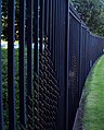 Car park security fencing. - geograph.org.uk - 499305.jpg 515 × 640; 131 KB
-
 Cardoness woods - geograph.org.uk - 498818.jpg 640 × 480; 107 KB
-
 Castell Llwyd - geograph.org.uk - 498027.jpg 640 × 480; 129 KB
-

-
 Cattle near Cunliffe's Farm - geograph.org.uk - 501120.jpg 640 × 480; 187 KB
-
 Cattle trough with distant Carningli - geograph.org.uk - 498005.jpg 640 × 480; 133 KB
-
 Cefn golau tredegar.jpg 640 × 480; 261 KB
-
 Channel Street, Galashiels - geograph.org.uk - 506312.jpg 640 × 480; 110 KB
-
 Chapel Street - geograph.org.uk - 498501.jpg 640 × 428; 51 KB
-
 Church Street, Launceston - geograph.org.uk - 503404.jpg 640 × 471; 109 KB
-
 Clay Lane - geograph.org.uk - 499930.jpg 640 × 480; 127 KB
-
 Clifftop fungus - geograph.org.uk - 501088.jpg 480 × 640; 119 KB
-
 Coast path at Scrade Water - geograph.org.uk - 501299.jpg 480 × 640; 131 KB
-
 Coastal path on Bynorth Cliff - geograph.org.uk - 501114.jpg 640 × 470; 110 KB
-
 Coed Pen-Arthur - geograph.org.uk - 509835.jpg 450 × 528; 69 KB
-
 Columns and Lake, Buscot Park - geograph.org.uk - 500714.jpg 640 × 427; 89 KB
-
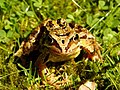 Common Frog, Glenmore - geograph.org.uk - 501703.jpg 640 × 480; 85 KB
-
 Compton House Chwilog - geograph.org.uk - 499546.jpg 640 × 428; 133 KB
-
 Cors y Garnedd from the north - geograph.org.uk - 499549.jpg 640 × 480; 125 KB
-
 Cors y Garnedd house - geograph.org.uk - 499202.jpg 640 × 480; 122 KB
-
 Cottage at Hermon - geograph.org.uk - 500937.jpg 640 × 470; 177 KB
-
 Cottages at Hermon - geograph.org.uk - 500941.jpg 640 × 480; 134 KB
-
 Cowiewaterata957 c michael hogan.jpg 640 × 480; 175 KB
-
 Cowlands at the head of Coombe Creek - geograph.org.uk - 711449.jpg 640 × 480; 58 KB
-
 Craighoar Hill - geograph.org.uk - 498542.jpg 640 × 480; 170 KB
-
 Cregennan - A National Trust Plaque - geograph.org.uk - 507437.jpg 640 × 480; 129 KB
-
 Crook Burn - geograph.org.uk - 498535.jpg 640 × 480; 110 KB
-
 Cross Keys Youth Centre, Stanley - geograph.org.uk - 499339.jpg 640 × 480; 329 KB
-
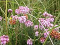 Cross-leaved heath, Erica tetralix - geograph.org.uk - 500445.jpg 640 × 480; 111 KB
-
 Croydon Old Lane - geograph.org.uk - 834420.jpg 640 × 480; 135 KB
-
 Cucklington - geograph.org.uk - 498012.jpg 640 × 414; 143 KB
-
 Cwm Berwyn Plantation from near Llethr Hafodydd - geograph.org.uk - 517955.jpg 1,600 × 1,072; 1.85 MB
-
 Cwm Berwyn Plantation, Ceredigion - geograph.org.uk - 508611.jpg 640 × 442; 159 KB
-
 Cwm Doethie Fawr, Ceredigion - geograph.org.uk - 515469.jpg 640 × 480; 136 KB
-
 Cwm Tyswg near Rhymney - geograph.org.uk - 500911.jpg 640 × 480; 271 KB
-

-
 Darton to Wakefield Line - geograph.org.uk - 498528.jpg 640 × 480; 113 KB
-
 Dizzard Point - geograph.org.uk - 498391.jpg 640 × 480; 131 KB
-
 Granite City. - geograph.org.uk - 499242.jpg 640 × 480; 94 KB
-
 Double Lobed (Apamea ophiogramma) - geograph.org.uk - 1146389.jpg 640 × 480; 35 KB
-
 Drakes Island Plymouth.jpg 640 × 414; 116 KB
-
 Drinking fountain - geograph.org.uk - 677979.jpg 640 × 480; 89 KB
-
 Drumaheglis Marina - geograph.org.uk - 497931.jpg 640 × 426; 93 KB
-
 Dyke in Laughton Forest - geograph.org.uk - 499732.jpg 640 × 480; 80 KB
-
 Dyke off North Carr Road - geograph.org.uk - 498900.jpg 640 × 480; 87 KB
-
 Cross Trails in Laughton Forest - geograph.org.uk - 498922.jpg 640 × 480; 140 KB
-
 Eastfield House Roos.jpg 640 × 451; 68 KB
-
 Elenydd Landscape across Figyn Blaenbrefi, Ceredigion - geograph.org.uk - 516579.jpg 1,600 × 1,110; 2.05 MB
-
-
 Elenydd Landscape, from near Esgair Llethr, Ceredigion - geograph.org.uk - 517299.jpg 1,600 × 1,128; 1.53 MB
-

-
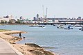
 Emsworth harbour - geograph.org.uk - 501954.jpg 640 × 480; 79 KB
-

-
-
 Entrance to Rhymney Cemetery - geograph.org.uk - 499824.jpg 640 × 480; 269 KB
-
 Entrance to Stanley Cemetery - geograph.org.uk - 499338.jpg 640 × 480; 457 KB
-

-
 Entrance to the park at Hanbury Hall - geograph.org.uk - 500262.jpg 640 × 480; 97 KB
-
-
 External concrete spiral stair. - geograph.org.uk - 499304.jpg 543 × 640; 108 KB
-
 Fairnley Farmhouse - geograph.org.uk - 498263.jpg 640 × 480; 84 KB
-
 Fairnley Plantation - geograph.org.uk - 498248.jpg 640 × 480; 66 KB
-
 Farm buildings at Gelli - geograph.org.uk - 1173280.jpg 640 × 480; 121 KB
-
 Farm buildings at Gelli, another view - geograph.org.uk - 1173290.jpg 640 × 480; 142 KB
-

-

-
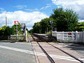 Ffairfach railway station in 2007.jpg 600 × 450; 63 KB
-
 Field beside Clopton Way - geograph.org.uk - 834432.jpg 640 × 480; 82 KB
-
 Figyn - geograph.org.uk - 501154.jpg 640 × 480; 116 KB
-
 Fine herbaceous border - geograph.org.uk - 503472.jpg 640 × 480; 144 KB
-
 Footbridge over River Wyre - geograph.org.uk - 514370.jpg 426 × 640; 395 KB
-
 Footpath - geograph.org.uk - 501180.jpg 480 × 640; 178 KB
-
 Footpath above Pwll Du quarry - geograph.org.uk - 498348.jpg 640 × 480; 174 KB
-
 Footpath Across Laurel's Mountain Llanteg - geograph.org.uk - 953135.jpg 640 × 480; 120 KB
-
 Footpath and Catcherside Plantation - geograph.org.uk - 498230.jpg 640 × 480; 51 KB
-
 Footpath to Barrow Bridge - geograph.org.uk - 501097.jpg 640 × 480; 209 KB
-

-
 Forest cycle route - geograph.org.uk - 498551.jpg 640 × 480; 166 KB
-
 Forest margin - geograph.org.uk - 541078.jpg 600 × 450; 68 KB
-

-

-
 Forest track footbridge over stream - geograph.org.uk - 499151.jpg 640 × 480; 139 KB
-

-
 Forestry near Llethr Hafodydd, Ceredigion - geograph.org.uk - 517288.jpg 640 × 454; 192 KB
-
 Forestry road - geograph.org.uk - 723913.jpg 640 × 338; 58 KB
-

-
 Forestry Road near Llethr Hafodydd, Ceredigion - geograph.org.uk - 517257.jpg 1,600 × 1,102; 1.51 MB
-
 Forestry Road near Rainfords Corner - geograph.org.uk - 498925.jpg 640 × 480; 108 KB
-

-
 Former tramway to Gilwern Hill quarries - geograph.org.uk - 498362.jpg 640 × 480; 132 KB
-
 Fountain - Norfolk Gardens - geograph.org.uk - 498067.jpg 640 × 413; 60 KB
-
 Frost-shattered rock outcrop - geograph.org.uk - 724357.jpg 640 × 480; 115 KB
-
 Furze Farm, Roos - geograph.org.uk - 498765.jpg 640 × 461; 144 KB
-
 Gala Park, Galashiels - geograph.org.uk - 568013.jpg 640 × 492; 108 KB
-
 Garden sheds at Saleway - geograph.org.uk - 501318.jpg 640 × 480; 96 KB
-
 Garenin village and crofts - geograph.org.uk - 1120294.jpg 640 × 480; 65 KB
-
 Gates at the south of Etal Manor estate - geograph.org.uk - 503443.jpg 640 × 480; 128 KB
-
 Gelli old farmhouse - geograph.org.uk - 515236.jpg 640 × 480; 173 KB
-
 Gelli, in need of rescue - geograph.org.uk - 498077.jpg 640 × 480; 124 KB
-
 Glen More - geograph.org.uk - 501660.jpg 640 × 430; 56 KB
-
 Glyndwr's Way - geograph.org.uk - 501317.jpg 640 × 480; 142 KB
-
 Graig - geograph.org.uk - 501298.jpg 640 × 480; 90 KB
-
 Graig Wood - geograph.org.uk - 501288.jpg 640 × 476; 112 KB
-
-
 Green lane - geograph.org.uk - 551522.jpg 600 × 450; 69 KB
-
 Green lane - Lôn las - geograph.org.uk - 498330.jpg 480 × 640; 140 KB
-
 Green Wood - geograph.org.uk - 498257.jpg 640 × 480; 96 KB
-
 Grimston Lodge - geograph.org.uk - 498804.jpg 640 × 493; 113 KB
-
 Groeslon Coed Garw Crossroads - geograph.org.uk - 502489.jpg 640 × 480; 127 KB
-

-
 Hanbury churchyard - geograph.org.uk - 500272.jpg 640 × 480; 122 KB
-
 Hanbury churchyard - geograph.org.uk - 500277.jpg 640 × 480; 104 KB


.jpg)


_-_geograph.org.uk_-_497906.jpg)
_-_geograph.org.uk_-_497907.jpg)
_-_geograph.org.uk_-_497909.jpg)


_-_geograph.org.uk_-_1146389.jpg)


