Category:United Kingdom photographs taken on 2018-07-25
Countries of Europe: Albania · Austria · Belgium · Bosnia and Herzegovina · Estonia · Finland · France‡ · Germany · Greece · Hungary · Iceland · Italy · Malta · Netherlands‡ · Norway · Poland · Portugal‡ · Romania · Russia‡ · Spain‡ · Sweden · Switzerland · Ukraine · United Kingdom
‡: partly located in Europe
‡: partly located in Europe
| ← | 25 July 2018 | → | ||
| ← | July 2018 | → | ||

United Kingdom photographs taken on 25 July 2018.
Image files should be categorized here automatically using {{taken on}} template. Direct categorisation is also possible, if automatic is impossible.
Subcategories
This category has only the following subcategory.
Media in category "United Kingdom photographs taken on 2018-07-25"
The following 109 files are in this category, out of 109 total.
-
 -2018-07-25 Artichoke public house, Magdalen Street, Norwich (1).jpg 800 × 583; 93 KB
-
 -2018-07-25 Artichoke public house, Magdalen Street, Norwich (2).jpg 800 × 591; 107 KB
-
 -2018-07-25 Artichoke public house, Magdalen Street, Norwich (3).jpg 800 × 600; 114 KB
-
 -2018-07-25 Artichoke public house, Magdalen Street, Norwich.jpg 800 × 600; 107 KB
-
 -2018-07-25 East along Nottingham Way, Great Yarmouth.jpg 800 × 583; 120 KB
-
 -2018-07-25 Former South Quay Surgery, Great Yarmouth.jpg 800 × 597; 87 KB
-
 -2018-07-25 Housing on South Quay, Great Yarmouth.jpg 800 × 588; 128 KB
-
 -2018-07-25 Howard’s fishmongers, Magdalen Street, Norwich.jpg 800 × 595; 115 KB
-
 -2018-07-25 Kings Head public house, Magdalen Street, Norwich (3).jpg 800 × 775; 138 KB
-
 -2018-07-25 Kings Head public house, Magdalen Street, Norwich (4).jpg 800 × 597; 119 KB
-
 -2018-07-25 Kings Head public house, Magdalen Street, Norwich (5).jpg 800 × 598; 125 KB
-
 -2018-07-25 Part of the city walls, Magdalen Street, Norwich.jpg 800 × 600; 169 KB
-
 -2018-07-25 Restaurants in Magdalen Street, Norwich.jpg 800 × 596; 104 KB
-
 -2018-07-25 Traffic lights on Magdalen Street, Norwich.jpg 800 × 595; 104 KB
-
 2018-07-23 Finger post direction sign, Craft Lane, Northrepps, Norfolk (1).JPG 3,864 × 5,152; 7.12 MB
-
 2018-07-23 Paston way, Foxhills woods, Northrepps, Norfolk (10).JPG 3,864 × 5,152; 7.93 MB
-
 2018-07-25 Countryside view, Paston way, Foxhills woods, Northrepps, Norfolk.JPG 5,152 × 3,864; 6.37 MB
-
 2018-07-25 Craft Lane, Northrepps, Norfolk (1).JPG 5,152 × 3,864; 7.05 MB
-
 2018-07-25 Craft Lane, Northrepps, Norfolk (2).JPG 5,152 × 3,864; 6.43 MB
-
 2018-07-25 Finger post direction sign, Craft Lane, Northrepps, Norfolk (2).JPG 3,864 × 5,152; 7.93 MB
-
 2018-07-25 Finger post direction sign, Craft Lane, Northrepps, Norfolk.JPG 5,152 × 3,864; 7.44 MB
-
 2018-07-25 Footpath in Foxhill woods, Northrepps (1).JPG 5,152 × 3,864; 8.32 MB
-
 2018-07-25 Footpath in Foxhill woods, Northrepps (2).JPG 3,864 × 5,152; 7.42 MB
-
 2018-07-25 Footpath in Foxhill woods, Northrepps (3).JPG 5,152 × 3,864; 8.7 MB
-
 2018-07-25 Footpath in Foxhill woods, Northrepps (4).JPG 5,152 × 3,864; 8.84 MB
-
 2018-07-25 Footpath sign, Paston way, Foxhills woods, Northrepps, Norfolk.JPG 3,864 × 5,152; 8.69 MB
-
 2018-07-25 Paston way, Foxhills woods, Northrepps, Norfolk (2).JPG 3,864 × 5,152; 7.08 MB
-
 2018-07-25 Paston way, Foxhills woods, Northrepps, Norfolk (3).JPG 3,864 × 5,152; 7.08 MB
-
 2018-07-25 Paston way, Foxhills woods, Northrepps, Norfolk (4).JPG 5,152 × 3,864; 8.03 MB
-
 2018-07-25 Paston way, Foxhills woods, Northrepps, Norfolk (5).JPG 5,152 × 3,864; 8.54 MB
-
 2018-07-25 Paston way, Foxhills woods, Northrepps, Norfolk (6).JPG 3,864 × 5,152; 7.69 MB
-
 2018-07-25 Paston way, Foxhills woods, Northrepps, Norfolk (7).JPG 5,152 × 3,864; 9.04 MB
-
 2018-07-25 Paston way, Foxhills woods, Northrepps, Norfolk (8).JPG 3,864 × 5,152; 8.45 MB
-
 2018-07-25 Paston way, Foxhills woods, Northrepps, Norfolk (9).JPG 3,864 × 5,152; 6.97 MB
-
 2018-07-25 Rectory Road, Northrepps, Norfolk (1).JPG 5,152 × 3,864; 7.66 MB
-
 2018-07-25 Rectory Road, Northrepps, Norfolk.JPG 3,864 × 5,152; 7.07 MB
-
 2018-07-25 Three ancient Oak trees, Foxhill woods, Northrepps.JPG 5,152 × 3,864; 8.09 MB
-
 Autumn-like landscape in July 2018 - Houghton Hall - geograph.org.uk - 5854176.jpg 5,184 × 3,888; 7.45 MB
-
 Barred Hook-tip (44935490621).jpg 1,500 × 1,134; 1.81 MB
-
 Blackfriars Ruins with Heritage Rose Garden Hereford UK.jpg 11,733 × 6,600; 52.4 MB
-
 Camberwell Submarine.jpg 4,032 × 3,024; 4.74 MB
-
 Camion Glaces Parking Spanish Battery Tynemouth North Tyneside 1.jpg 3,024 × 4,032; 2.79 MB
-
 Charlestown Harbour.jpg 2,048 × 1,536; 849 KB
-
 Cherry Groce memorial.jpg 3,024 × 4,032; 4.06 MB
-
 Consistory Court in St Peter's Church, Carmarthen.jpg 2,448 × 3,264; 1.27 MB
-
 Dalbeattie Street, Harpurhey.jpg 2,560 × 1,920; 2.38 MB
-
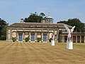
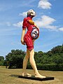
 Damien Hirst at Houghton Hall 2018 - Charity - geograph.org.uk - 5854161.jpg 5,067 × 3,801; 3.41 MB
-
 Damien Hirst at Houghton Hall 2018 - Legend - geograph.org.uk - 5854349.jpg 5,184 × 3,888; 3.35 MB
-
 Damien Hirst at Houghton Hall 2018 - Myth - geograph.org.uk - 5857359.jpg 5,184 × 3,888; 3.67 MB
-
 Damien Hirst at Houghton Hall 2018 - Myth and Legend - geograph.org.uk - 5854339.jpg 5,017 × 3,763; 2.86 MB
-
 Damien Hirst at Houghton Hall 2018 - Temple (Close look) - geograph.org.uk - 5857809.jpg 3,888 × 5,184; 3.72 MB
-
 Damien Hirst at Houghton Hall 2018 - Temple (Front view) - geograph.org.uk - 5857806.jpg 5,184 × 3,888; 3.97 MB
-
 Damien Hirst at Houghton Hall 2018 - Temple (Rear view) - geograph.org.uk - 5857813.jpg 5,184 × 3,888; 3.25 MB
-
-

-

-
-

-

-
 Deer near Houghton Hall in Norfolk - geograph.org.uk - 5854325.jpg 5,184 × 3,888; 4.38 MB
-
 Demolition of the former Yorkshire Tile Company building (geograph 5860427).jpg 1,024 × 768; 120 KB
-
 Dugdales Mill, Holmes Road, Sowerby Bridge (geograph 5860448).jpg 1,024 × 766; 248 KB
-
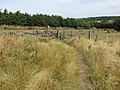 Field path and stile near Clifton (geograph 5854147).jpg 4,000 × 3,000; 4.54 MB
-
 Front view of tower of St Peter's Church, Carmarthen.jpg 2,448 × 3,264; 2.73 MB
-
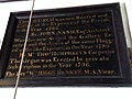
 HDR 330 Bridge plaque 9588.jpg 4,608 × 3,456; 3.51 MB
-
 Lamp post to the south of the Hayes Island, Cardiff, July 2018.jpg 1,536 × 2,048; 1.14 MB
-
 Masonry in the riverbed, Sowerby Bridge (geograph 5860467).jpg 1,024 × 768; 282 KB
-
 Mayor's chair in St Peter's Church, Carmarthen.jpg 3,264 × 2,448; 1.48 MB
-
 Medway Bridge 9594.jpg 4,608 × 3,456; 2.02 MB
-
 Modern art at Houghton Hall 2018 - geograph.org.uk - 5854300.jpg 3,888 × 5,184; 5.06 MB
-
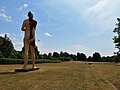
 Modern art in front of Houghton Hall - geograph.org.uk - 5857366.jpg 5,050 × 3,787; 3.23 MB
-
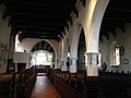 Nave of St Peter's Church, Carmarthen.jpg 3,264 × 2,448; 1.38 MB
-
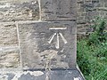 Ordnance Survey Cut Mark (geograph 5854163).jpg 3,871 × 2,903; 3.21 MB
-
 Parched lawn at Houghton Hall in Norfolk - geograph.org.uk - 5857408.jpg 5,067 × 3,801; 3.38 MB
-
 Pathway between housing at Dewsbury Moor (geograph 5856465).jpg 4,000 × 3,000; 3.78 MB
-
 Plage Haven Tynemouth North Tyneside 1.jpg 4,032 × 3,024; 3.05 MB
-
 Plage Haven Tynemouth North Tyneside 2.jpg 6,498 × 3,970; 6.98 MB
-
 PWS2 883A Bridge plaque 9613.jpg 4,608 × 3,456; 3.55 MB
-
 PWS2 887 Bridge plaque 9617.jpg 4,608 × 3,456; 3.63 MB
-
 Radar GBSAR Parking Spanish Battery Tynemouth North Tyneside 1.jpg 4,032 × 3,024; 3.24 MB
-
 Radar GBSAR Parking Spanish Battery Tynemouth North Tyneside 2.jpg 4,032 × 3,024; 3.1 MB
-
 Radar GBSAR Parking Spanish Battery Tynemouth North Tyneside 3.jpg 4,032 × 3,024; 3.82 MB
-
 Radar GBSAR Parking Spanish Battery Tynemouth North Tyneside 4.jpg 4,032 × 3,024; 1.33 MB
-
 Radar GBSAR Parking Spanish Battery Tynemouth North Tyneside 5.jpg 4,032 × 3,024; 1.36 MB
-
 Radar GBSAR Parking Spanish Battery Tynemouth North Tyneside 6.jpg 4,032 × 3,024; 3.21 MB
-
 Radar GBSAR Parking Spanish Battery Tynemouth North Tyneside 7.jpg 4,032 × 3,024; 2.45 MB
-
 Roman altar (Mithraic) in porch of St Peter's Church, Carmarthen.jpg 2,448 × 3,264; 1.41 MB
-
 Scanner Laser Parking Spanish Battery Tynemouth North Tyneside 1.jpg 3,024 × 4,032; 3.12 MB
-
 Scorched grass in the parkland at Houghton Hall - geograph.org.uk - 5854203.jpg 5,184 × 3,888; 4.69 MB
-
 Sign in porch of St Peter's Church, Carmarthen 2.jpg 3,264 × 2,448; 1.65 MB
-
 Sign in porch of St Peter's Church, Carmarthen.jpg 2,448 × 2,448; 1.08 MB
-
 The Church of St John the Evangelist at Clifton (geograph 5854140).jpg 4,000 × 3,000; 2.84 MB
-

-
 Tower of St Peter's Church, Carmarthen.jpg 2,448 × 3,264; 2.8 MB
-
 Track Road approaching Halifax Road (A638) at Batley Carr (geograph 5856469).jpg 4,000 × 3,000; 3.8 MB
-
 Tree of life stained glass window at St Peter's Church, Carmarthen.jpg 2,448 × 3,264; 826 KB
-
 VIR 1046 Medway Bridge plaque 9592.jpg 4,608 × 3,456; 3.52 MB
-
 VIR 1084 Bridge plaque 9595.jpg 4,608 × 3,456; 3.47 MB
-
 VIR 132 Bridge plaque 9614.jpg 4,608 × 3,456; 3.23 MB
-
 VIR 149 Bridge plaque 9599.jpg 4,608 × 3,456; 3.3 MB
-
 Water tower (reservoir) in the parkland of Houghton Hall - geograph.org.uk - 5854190.jpg 5,067 × 3,801; 2.75 MB
-

-
 Waterflame in the walled garden of Houghton Hall - Start up - geograph.org.uk - 5858204.jpg 5,184 × 3,888; 4.91 MB
-
 Waterflame in the walled garden of Houghton Hall in Norfolk - geograph.org.uk - 5858216.jpg 5,184 × 3,888; 4.67 MB
-
 Waterflame in the walled garden of Houghton Hall, Norfolk - geograph.org.uk - 5858234.jpg 2,930 × 3,963; 1.76 MB
-
 Wellington Street, Batley (geograph 5856474).jpg 4,000 × 3,000; 3.23 MB
-
 Whitbyabbey-1.jpg 3,036 × 4,048; 4.76 MB
-
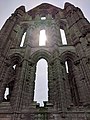 Whitbyabbey-2.jpg 3,036 × 4,048; 4.11 MB
-
 Whitbyabbey-3.jpg 4,048 × 3,036; 4.41 MB
.jpg)
.jpg)
.jpg)


.jpg)
.jpg)
.jpg)


.JPG)
.JPG)

.JPG)
.JPG)
.JPG)

.JPG)
.JPG)
.JPG)
.JPG)

.JPG)
.JPG)
.JPG)
.JPG)
.JPG)
.JPG)
.JPG)
.JPG)
.JPG)


.jpg)


_-_geograph.org.uk_-_5857809.jpg)
_-_geograph.org.uk_-_5857806.jpg)
_-_geograph.org.uk_-_5857813.jpg)
_-_geograph.org.uk_-_5857834.jpg)
_-_geograph.org.uk_-_5857830.jpg)
_-_geograph.org.uk_-_5857818.jpg)
_-_geograph.org.uk_-_5857865.jpg)
_-_geograph.org.uk_-_5857846.jpg)
_-_geograph.org.uk_-_5857852.jpg)

.jpg)
.jpg)
.jpg)


.jpg)


.jpg)

.jpg)


_in_porch_of_St_Peter%27s_Church,_Carmarthen.jpg)


.jpg)


_at_Batley_Carr_(geograph_5856469).jpg)


_in_the_parkland_of_Houghton_Hall_-_geograph.org.uk_-_5854190.jpg)


.jpg)


