Category:Utah State Route 260 (1957-1981)
former state highway in Daggett County, Utah, United States  | |||||
| Upload media | |||||
| Instance of | |||||
|---|---|---|---|---|---|
| Location | Daggett County, Utah | ||||
| Located in or next to body of water | |||||
| Transport network | |||||
| Owned by |
| ||||
| Maintained by |
| ||||
| Inception |
| ||||
| Dissolved, abolished or demolished date |
| ||||
| Length |
| ||||
| Terminus | |||||
| Replaced by | |||||
 | |||||
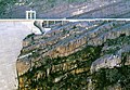
English: Media related to Utah State Route 260 (1957-1981) (SR-260), a former 16.9361-mile (27.2560 km) state highway in Daggett County, Utah, United States, that connected Utah State Route 44 (SR-44) at Greendale Junction (SR-44's current southern terminus) with the former Wyoming Highway 373 (WYO 373) in Wyoming (south of Minnies Gap).
Originally, the northern terminus was farther west and connected with Utah State Route 43 in the former town of Linwood (about 4 miles [6.4 km] east of Manila). When Linwood was flooded by the Flaming Gorge Reservoir (beginning in the late 1950s), the northern terminus of SR-260 was truncated back to Dutch John. Eventually a new roadway was completed to connect Dutch John with the southern end of Wyoming Highway 373 (a newly constructed road) and SR-260 was routed along the new roadway. In 1981 the entire route was replaced by the new routing of U.S. Route 191.
Originally, the northern terminus was farther west and connected with Utah State Route 43 in the former town of Linwood (about 4 miles [6.4 km] east of Manila). When Linwood was flooded by the Flaming Gorge Reservoir (beginning in the late 1950s), the northern terminus of SR-260 was truncated back to Dutch John. Eventually a new roadway was completed to connect Dutch John with the southern end of Wyoming Highway 373 (a newly constructed road) and SR-260 was routed along the new roadway. In 1981 the entire route was replaced by the new routing of U.S. Route 191.
Subcategories
This category has only the following subcategory.
Media in category "Utah State Route 260 (1957-1981)"
The following 3 files are in this category, out of 3 total.
-
 Flaming Gorge 1997.jpg 992 × 688; 1.06 MB
-
 Utah 260.svg 750 × 600; 74 KB
-
 Utah SR 260.svg 385 × 385; 10 KB

