Category:Wasserturm Schöna-Kolpien
| Object location | | View all coordinates using: OpenStreetMap |
|---|
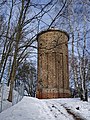
This is the category of the Brandenburger Baudenkmal (cultural heritage monument) with the ID 09105500 (Wikidata)
|
 | |||||
| Upload media | |||||
| Instance of | |||||
|---|---|---|---|---|---|
| Location | Schöna-Kolpien, Dahme/Mark, Amt Dahme/Mark, Teltow-Fläming District, Brandenburg, Germany | ||||
| Heritage designation | |||||
 | |||||
Media in category "Wasserturm Schöna-Kolpien"
The following 4 files are in this category, out of 4 total.
-
 Dahme Mark Schoena Kolpien Wasserturm.jpg 1,244 × 1,658; 899 KB
-
 Dahme Schoena-Kolpien Wasserturm 2021.jpg 3,000 × 4,000; 3.28 MB
-
 Lausitz Luftsport- & Techniktage 2013-Rueckflug by-RaBoe 088.jpg 2,600 × 1,727; 697 KB
-
 Schoena-Kolpien Wasserturm .jpg 3,648 × 5,472; 1.5 MB


