Category:Wyoming gubernatorial election maps (set)
States of the United States: Alabama · Alaska · Arizona · Arkansas · California · Colorado · Connecticut · Delaware · Florida · Georgia · Hawaii · Idaho · Illinois · Indiana · Iowa · Kansas · Kentucky · Louisiana · Maine · Maryland · Massachusetts · Michigan · Minnesota · Mississippi · Missouri · Montana · Nebraska · Nevada · New Hampshire · New Jersey · New Mexico · New York · North Carolina · North Dakota · Ohio · Oklahoma · Oregon · Pennsylvania · Rhode Island · South Carolina · South Dakota · Tennessee · Texas · Utah · Vermont · Virginia · Washington · West Virginia · Wisconsin · Wyoming
Guam
Guam
This category is an image set. It should contain only images that have the same style, and should have a parent category that is purely topical.
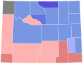
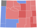
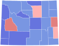
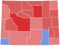
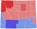
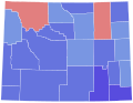
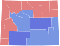
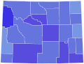
Media in category "Wyoming gubernatorial election maps (set)"
The following 30 files are in this category, out of 30 total.
-
 1914 Wyoming gubernatorial election results map by county.svg 810 × 624; 15 KB
-
 1918 Wyoming gubernatorial election results map by county.svg 810 × 624; 15 KB
-
 1922 Wyoming gubernatorial election results map by county.svg 810 × 624; 17 KB
-

-
 1926 Wyoming gubernatorial election results map by county.svg 810 × 624; 17 KB
-
 1930 Wyoming gubernatorial election results map by county.svg 810 × 624; 15 KB
-
 1932 Wyoming gubernatorial election results map by county.svg 810 × 624; 14 KB
-
 1934 Wyoming gubernatorial election results map by county.svg 810 × 624; 14 KB
-
 1938 Wyoming gubernatorial election results map by county.svg 810 × 624; 14 KB
-
 1942 Wyoming gubernatorial election results map by county.svg 810 × 624; 14 KB
-
 1946 Wyoming gubernatorial election results map by county.svg 810 × 624; 14 KB
-
 1950 Wyoming gubernatorial election results map by county.svg 810 × 624; 14 KB
-
 1954 Wyoming gubernatorial election results map by county.svg 810 × 624; 14 KB
-
 1958 Wyoming gubernatorial election results map by county.svg 810 × 624; 14 KB
-
 1962 Wyoming gubernatorial election results map by county.svg 810 × 624; 14 KB
-
 1966 Wyoming gubernatorial election results map by county.svg 810 × 624; 15 KB
-
 1970 Wyoming gubernatorial election results map by county.svg 810 × 624; 15 KB
-
 1974 Wyoming gubernatorial election results map by county.svg 810 × 624; 15 KB
-
 1978 Wyoming gubernatorial election results map by county.svg 810 × 624; 15 KB
-
 1982 Wyoming gubernatorial election results map by county.svg 810 × 624; 15 KB
-
 1986 Wyoming gubernatorial election results map by county.svg 810 × 624; 15 KB
-
 1990 Wyoming gubernatorial election results map by county.svg 810 × 624; 15 KB
-
 1994 Wyoming gubernatorial election results map by county.svg 810 × 624; 15 KB
-
 1998 Wyoming gubernatorial election results map by county.svg 810 × 624; 15 KB
-
 2002 Wyoming gubernatorial election results map by county.svg 810 × 624; 15 KB
-
 2006 Wyoming gubernatorial election results map by county.svg 810 × 624; 15 KB
-
 2010 Wyoming gubernatorial election results map by county.svg 810 × 624; 15 KB
-
 2014 Wyoming gubernatorial election results map by county.svg 810 × 624; 15 KB
-
 2018 Wyoming gubernatorial election results map by county.svg 810 × 624; 15 KB
-
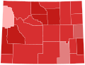 2022 Wyoming gubernatorial election results map by county.svg 810 × 624; 15 KB


