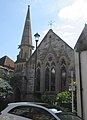
Category:Yarmouth Methodist Church, Yarmouth, Isle of Wight
| Object location | | View all coordinates using: OpenStreetMap |
|---|
This is a category about listed building number 1220907. |
protestant church building in Yarmouth, Isle of Wight, UK  | |||||
| Upload media | |||||
| Instance of | |||||
|---|---|---|---|---|---|
| Location | Yarmouth, Isle of Wight, South East England, England | ||||
| Heritage designation |
| ||||
 | |||||
Media in category "Yarmouth Methodist Church, Yarmouth, Isle of Wight"
The following 3 files are in this category, out of 3 total.
-

-
-
 Yarmouth Methodist Church.JPG 1,528 × 2,296; 1.2 MB
_(1).JPG)
_(2).JPG)