File:105284 petah tikva beit svetitzky PikiWiki Israel.jpg

Size of this preview: 800 × 451 pixels. Other resolutions: 320 × 180 pixels | 640 × 361 pixels | 1,024 × 577 pixels | 1,280 × 721 pixels | 2,560 × 1,443 pixels | 3,648 × 2,056 pixels.
Original file (3,648 × 2,056 pixels, file size: 2.45 MB, MIME type: image/jpeg)
Captions
Captions
Add a one-line explanation of what this file represents
| Description |
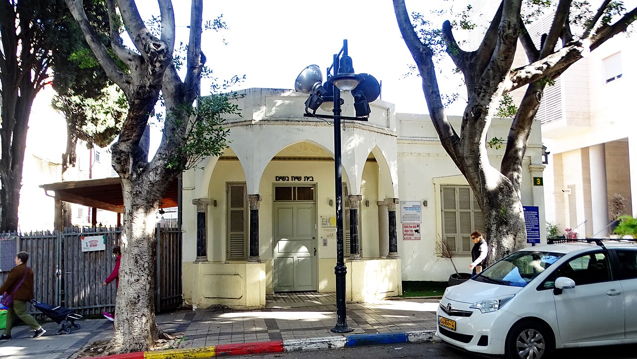
English: Name: Petah Tikva Beit Svetitzky Description: The house was built in the colony in the early 1920s by Avraham Svetitsky, a native of a village in the Minsk region of Russia, who immigrated to Israel in 1881, as a youth, and engaged in agriculture. Svetitsky was influenced in the construction of his house by the style of construction in the city of Odessa. The construction of the house lasted six months. עברית: שם: פתח תקוה בית סווטיצקי תיאור: הבית נבנה במושבה בתחילת שנות ה-20 של המאה ה-20 על ידי אברהם סווטיצקי, יליד כפר בפלך מינסק שברוסיה, שעלה לארץ ישראל ב-1881, בצעירותו, ועסק בחקלאות. סווטיצקי הושפע בבניית ביתו מסגנון הבנייה בעיר אודסה. בניית הבית נמשכה חצי שנה. הערות: המבנה כולל 5 חדרים, מרפסת וגינה. לגג ולמרפסת גימור ועיצוב ייחודיים. הבית נבנה מלבני סיליקט.בבית התגוררו בני משפחת סווטיצקי למשך תקופה קצרה. בשנת 1930 הוא הושכר לבנק אפ"ק, בשל מיקומו המרכזי והמחסור במבנים מתאימים בפתח תקווה; הבית שימש כמשרדי הבנק במשך כ 6 שנים,כיום נחשב המבנה אתר מורשת לשימור. הוא שופץ בתחילת העשור הראשון של המאה ה-21. באוקטובר 2013 נפתח בו "בית שיח נשים - בית נשים ומשפחה", של המוזיאון לתולדות פתח תקווה, להנצחת פעילותן של נשות העיר.(ויקיפדיה) מיקום: מונטפיורי 3 פתח תקוה קובץ מקורי: DSC03340.JPG |
| Date | 18.1.2024 |
| Source | Zalmanson Zeller via the PikiWiki - Israel free image collection project |
| Author | זלר זלמנסון |
| Permission (Reusing this file) |
This file is licensed under the Creative Commons Attribution 2.5 Generic license. Attribution: Zeller Zalmanson Pikiwiki Israel
|

|
This file has been submitted through the Israeli Pikiwiki project and uploaded here automatically.
The project is cooperation between the Israel Internet Association and Wikimedia Israel in an effort to promote the concept of free content on the Web, by creating an image collection of digital-format, good quality photographs, documenting events relating to the history of Israel, or depicting places of distinction in Israel and the Middle East. The Pikiwiki Project is managed from 2021 by the "Heritage Stones" group.
Please consider notifying the project before renaming or deleting this file. Further information about the project can be found on the commons-l mailing list.
|
File history
Click on a date/time to view the file as it appeared at that time.
| Date/Time | Thumbnail | Dimensions | User | Comment | |
|---|---|---|---|---|---|
| current | 00:25, 12 February 2024 | | 3,648 × 2,056 (2.45 MB) | Pikiwikisrael (talk | contribs) |
You cannot overwrite this file.
File usage on Commons
There are no pages that use this file.