File:111.01845E 30.83424N Three Gorges Dam.png

Size of this preview: 800 × 493 pixels. Other resolutions: 320 × 197 pixels | 640 × 394 pixels | 990 × 610 pixels.
Original file (990 × 610 pixels, file size: 1.16 MB, MIME type: image/png)
Captions
Captions
Add a one-line explanation of what this file represents
Summary
edit
| Description |
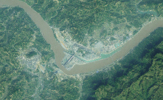
English: NASA World Wind image of the Three Gorges Dam, using the I-Cubed Landsat overlay. Altitude is 11km. |
| Date | |
| Source | NASA World Wind Landsat 7 I-Cubed overlay |
| Author | NASA Landsat |
Licensing
edit
| This image is in the public domain because it is a screenshot from NASA’s globe software World Wind using a public domain layer, such as Blue Marble, MODIS, Landsat, SRTM, USGS or GLOBE.
|
 |
File history
Click on a date/time to view the file as it appeared at that time.
| Date/Time | Thumbnail | Dimensions | User | Comment | |
|---|---|---|---|---|---|
| current | 03:55, 16 May 2013 | | 990 × 610 (1.16 MB) | Oaktree b (talk | contribs) | User created page with UploadWizard |
You cannot overwrite this file.
File usage on Commons
The following page uses this file: