File:1696 Coronelli Map of the Great Lakes (Most Accurate Map of the Great Lakes in the 17th Century) - Geographicus - LaLouisiana-coronelli-1695.jpg
Size of this preview: 800 × 495 pixels. Other resolutions: 320 × 198 pixels | 640 × 396 pixels | 1,024 × 633 pixels | 1,280 × 792 pixels | 2,560 × 1,583 pixels | 4,000 × 2,474 pixels.
Original file (4,000 × 2,474 pixels, file size: 2.95 MB, MIME type: image/jpeg)
Captions
Captions
Add a one-line explanation of what this file represents
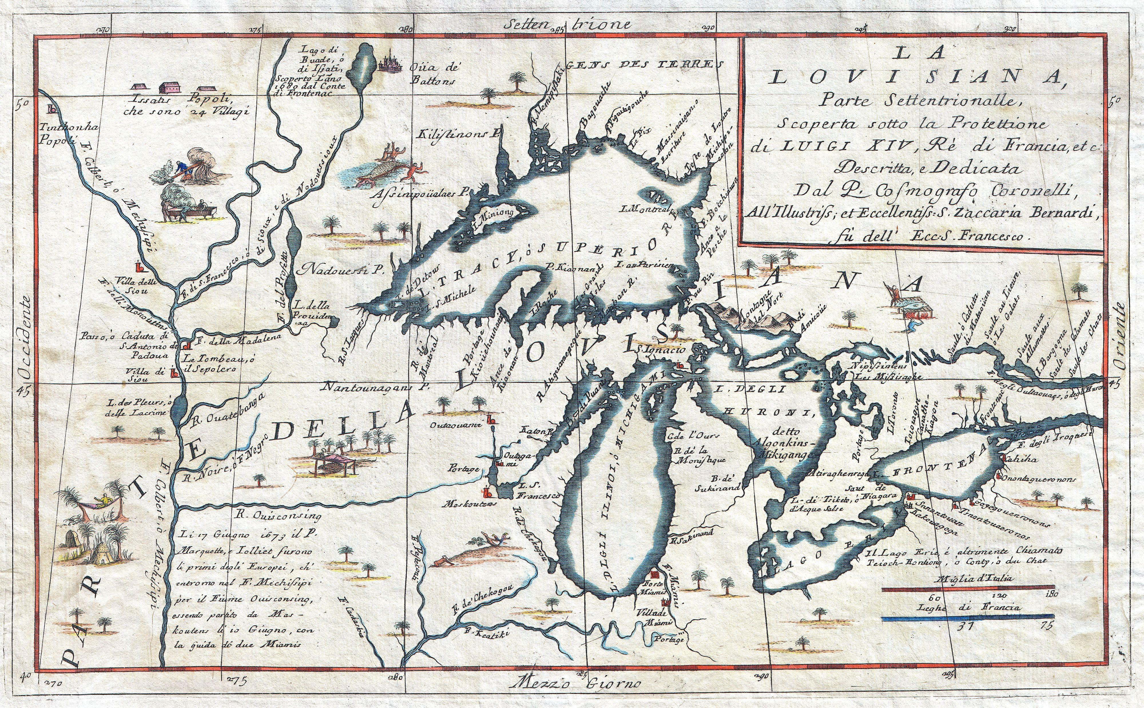
| Vincenzo Coronelli: La Louisiana, Parte Settentrionalle, Scoperta sotto la Protettione di Luigi XIV, Ré di Francia et Descritta, e Dedicata Dal P. Cosmografo Coronelli, All'Illustriss, et Eccellentiss, S. Zaccaria Bernardi su dell Ecc. S. Francesco.
( |
|||||||||||||||||||||||||||
|---|---|---|---|---|---|---|---|---|---|---|---|---|---|---|---|---|---|---|---|---|---|---|---|---|---|---|---|
| Artist |
|
||||||||||||||||||||||||||
| Title |
La Louisiana, Parte Settentrionalle, Scoperta sotto la Protettione di Luigi XIV, Ré di Francia et Descritta, e Dedicata Dal P. Cosmografo Coronelli, All'Illustriss, et Eccellentiss, S. Zaccaria Bernardi su dell Ecc. S. Francesco. |
||||||||||||||||||||||||||
| Description |
English: This exceedingly rare 1694 map by Vincenzo Coronelli is the most important depiction of the Great Lakes and the headwaters of the Mississippi River to appear in the late 17th century. Covers all five Great Lakes and extends westward as far as the Mississippi River valley. This map is a careful study of the Great Lakes Region and reveals Coronelli’s fascination with this area. Coronelli derived his cartographic information from the reports of Jesuit Missionaries who were actively proselytizing in this region throughout the mid to late 18th century. These included the explorations of La Salle, Hennepin, Marquette and Jolliet, among others. Dotted with forts, Indian villages, and missionary stations. Shows the R. De Chekagou roughly where Chicago is today. Shows the Ottawa River route into Georgian Bay anda well developed mapping of Green Bay. This is also the most accurate early mapping of Lake Superior, in which both Keweenaw Peninsula (P. Kioanan) and Isle Royale (I. Miniong) are located. Features none of the mythical islands that appear in the Bellin map which appeared 100 years later. Decorated with numerous wonderful vignettes depicting the lives of American Indians. One in particular, a crocodile eating a man, is interesting and incongruous. This map is essentially an elaboration upon the 1688 Nolin/Coronelli map, Partie Occidentale du Canada ou de la Nouvelle France…” It was prepared for inclusion in the second edition of Coronelli's important 1695 Atlante Veneto . Français : Cette carte très rare de 1794 par Vincenzo Coronelli est la représentation la plus importante de la région des Grands Lacs et du cours supérieur du Mississipi à la fin du 17ème siècle. Elle couvre les cinq Grands Lacs et s'étend vers l'ouest jusqu'à la vallée du fleuve Mississipi. Cette carte est une étude soignée de la région des Grands Lacs et révèle la fascination de Coronelli pour cette zone. Coronelli tirait son information cartographique des rapports des missionnaires jésuites qui ont fait preuve d'un prosélytisme actif dans cette région dans la seconde moitié du 18e siècle. Elle comprend notamment des explorations de La Salle, Hennepin, Marquette et Jolliet, entre autres. Elle indique les forts, les villages indiens, et les missions. Elle montre la rivière De Chekagou à peu près où Chicago est aujourd'hui, le cours de la rivière des Outaouais dans la baie Georgienne, et une cartographie bien développée de Green Bay. C'est aussi la première cartographie aussi précise du lac Supérieur , dans lequel sont situées la péninsule Keweenaw ( P. Kiaonan ) et l'île Royale ( I. Miniong ). Ne figurent aucunes des îles mythiques qui apparaissent dans la carte Bellin qui est apparue 100 ans plus tard. Elle est décorée avec de nombreuses vignettes merveilleuses dépeignant la vie des Indiens d'Amérique. Une en particulier, un crocodile mangeant un homme, est intéressante et incongrue. Cette carte est essentiellement une élaboration de la carte de 1688 Nolin / Coronelli , "Partie Occidentale du Canada ou de la Nouvelle France ... " Elle a été préparée pour être incluse dans la deuxième édition de l'important Atlante Veneto de Coronelli de 1695. |
||||||||||||||||||||||||||
| Date | circa 1695 (undated) | ||||||||||||||||||||||||||
| Dimensions | height: 10.5 in (26.6 cm); width: 16.5 in (41.9 cm) | ||||||||||||||||||||||||||
| Accession number |
Geographicus link: LaLouisiana-coronelli-1695 |
||||||||||||||||||||||||||
| Inscriptions |
Caption top right: LA LOVISIANA, Parte Settentrionalle, Scoperta sotto la Protettione di Luigi XIV, Ré di Francia et Descritta, e Dedicata Dal P. Cosmografo Coronelli, All'Illustriss, et Eccellentiss, S. Zaccaria Bernardi su dell Ecc. S. Francesco. bottom left: Li 17 Giugno 1673 il P. Marquette, e Iolliet furono li primi degli Europei, ch'entrono nel F. Meschissipi per il Fiume Ouisconsing, essendo partito da Mas - koutens li io Giugno, con la Guida di due Miamis |
||||||||||||||||||||||||||
| Source/Photographer |
Coronelli, Vincento. Atlante Veneto, 1695 2nd edition.
|
||||||||||||||||||||||||||
| Permission (Reusing this file) |
|
||||||||||||||||||||||||||

File history
Click on a date/time to view the file as it appeared at that time.
| Date/Time | Thumbnail | Dimensions | User | Comment | |
|---|---|---|---|---|---|
| current | 08:33, 18 March 2011 | | 4,000 × 2,474 (2.95 MB) | BotMultichill (talk | contribs) | {{subst:User:Multichill/Geographicus |link=http://www.geographicus.com/P/AntiqueMap/LaLouisiana-coronelli-1695 |product_name=1696 Coronelli Map of the Great Lakes (Most Accurate Map of the Great Lakes in the 17th Century) |map_title=La Louisiana, Parte Se |
You cannot overwrite this file.
File usage on Commons
The following 2 pages use this file:
_-_Geographicus_-_LaLouisiana-coronelli-1695.jpg)
File usage on other wikis
The following other wikis use this file:
- Usage on de.wikipedia.org
- Usage on fr.wikipedia.org
_-_Geographicus_-_LaLouisiana-coronelli-1695.jpg&oldid=744107846)