File:1730 Covens and Mortier Map of Germany ( Folding Case Map ) - Geographicus - Germaniae-covensmortier-1720.jpg

Size of this preview: 711 × 600 pixels. Other resolutions: 285 × 240 pixels | 569 × 480 pixels | 910 × 768 pixels | 1,214 × 1,024 pixels | 2,428 × 2,048 pixels | 6,000 × 5,062 pixels.
Original file (6,000 × 5,062 pixels, file size: 9.91 MB, MIME type: image/jpeg)
Captions
Captions
Add a one-line explanation of what this file represents
Summary
edit_-_Geographicus_-_Germaniae-covensmortier-1720.jpg&action=edit§ion=1)
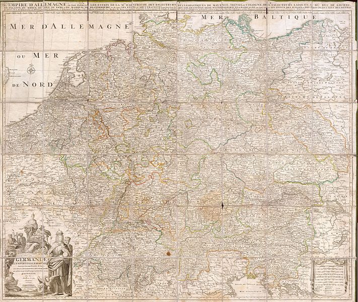
| Germaniae L’Empire D’ Allemagne distingue suivant l’etendue tous les etats, principautes et souveradnettes qui passent ou qui ont passé jusque a present sous la nome D’Allemagne sur les Memoires les plus Nouveaux. | ||||||
|---|---|---|---|---|---|---|
| Artist | ||||||
| Title |
Germaniae L’Empire D’ Allemagne distingue suivant l’etendue tous les etats, principautes et souveradnettes qui passent ou qui ont passé jusque a present sous la nome D’Allemagne sur les Memoires les plus Nouveaux. |
|||||
| Description |
English: This is an extraordinary and gigantic c. 1730 map of Germany and the surrounding nations. Map is presented in case or pocket format on 48 linen backed panels. Covers most of what is today central Europe from eastern France and the Netherlands to Poland and Hungary to northern Italy and Greece. Large decorative cartouche in the lower left depicts both the royalty and trade riches of the region. Produced by the firm of Coven’s and Mortier, undated by likely about c. 1730. |
|||||
| Date | circa 1730 | |||||
| Dimensions | height: 49 in (124.4 cm); width: 42 in (106.6 cm) | |||||
| Accession number |
Geographicus link: Germaniae-covensmortier-1720 |
|||||
| Source/Photographer |
|
|||||
| Permission (Reusing this file) |
|
|||||
File history
Click on a date/time to view the file as it appeared at that time.
| Date/Time | Thumbnail | Dimensions | User | Comment | |
|---|---|---|---|---|---|
| current | 08:40, 24 March 2011 | | 6,000 × 5,062 (9.91 MB) | BotMultichillT (talk | contribs) | {{subst:User:Multichill/Geographicus |link=http://www.geographicus.com/P/AntiqueMap/Germaniae-covensmortier-1720 |product_name=1730 Covens and Mortier Map of Germany ( Folding Case Map ) |map_title=Germaniae L’Empire D’ Allemagne distingue suivant l� |
You cannot overwrite this file.
File usage on Commons
The following page uses this file:
_-_Geographicus_-_Germaniae-covensmortier-1720.jpg)
File usage on other wikis
The following other wikis use this file:
- Usage on de.wikipedia.org
_-_Geographicus_-_Germaniae-covensmortier-1720.jpg&oldid=859095346)