File:1771 Bonne Map of Central Asia - Geographicus - Tartarie-bonne-1770.jpg

Size of this preview: 800 × 562 pixels. Other resolutions: 320 × 225 pixels | 640 × 449 pixels | 1,024 × 719 pixels | 1,280 × 899 pixels | 2,560 × 1,797 pixels | 4,000 × 2,808 pixels.
Original file (4,000 × 2,808 pixels, file size: 3.34 MB, MIME type: image/jpeg)
Captions
Captions
Add a one-line explanation of what this file represents
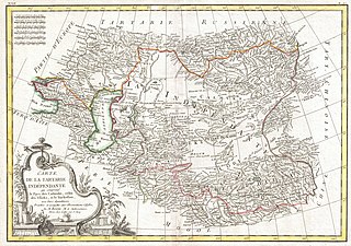
| Rigobert Bonne: Carte de la Tartarie Independante qui comprend le Pays de Calmuks, celui des Usbeks, et le Turkestan avec leurs dependances.
( |
|||||||||||||||||||||||
|---|---|---|---|---|---|---|---|---|---|---|---|---|---|---|---|---|---|---|---|---|---|---|---|
| Artist |
|
||||||||||||||||||||||
| Title |
Carte de la Tartarie Independante qui comprend le Pays de Calmuks, celui des Usbeks, et le Turkestan avec leurs dependances. |
||||||||||||||||||||||
| Description |
English: A beautiful example of Rigobert Bonne's 1770 decorative map of Central Asia. Covers from the Black Sea south to China, north to Russia, and south to Persia and India. Includes the modern day nations of Kazakhstan, Uzbekistan, Turkmenistan, Georgia, Armenia, and Azerbaijan, with parts of adjacent Turkey, Saudi Arabia, and Pakistan. Names numerous tribal areas, villages, cities, deserts, Silk Route way stations, and river systems. A large decorative title cartouche in the lower left quadrant features articles supposedly common to the region. Drawn by R. Bonne in 1770 for issue as plate no. B 27 in Jean Lattre's 1776 issue of the Atlas Moderne . |
||||||||||||||||||||||
| Date | 1770 (undated) | ||||||||||||||||||||||
| Dimensions | height: 12.5 in (31.7 cm); width: 17.5 in (44.4 cm) | ||||||||||||||||||||||
| Accession number |
Geographicus link: Tartarie-bonne-1770 |
||||||||||||||||||||||
| Source/Photographer |
Lattre, Jean, Atlas Moderne ou Collection de Cartes sur Toutes les Parties du Globe Terrestre, c. 1775.
|
||||||||||||||||||||||
| Permission (Reusing this file) |
|
||||||||||||||||||||||
| Other versions |
|
||||||||||||||||||||||
.jpg)

File history
Click on a date/time to view the file as it appeared at that time.
| Date/Time | Thumbnail | Dimensions | User | Comment | |
|---|---|---|---|---|---|
| current | 03:05, 23 March 2011 | | 4,000 × 2,808 (3.34 MB) | BotMultichillT (talk | contribs) | {{subst:User:Multichill/Geographicus |link=http://www.geographicus.com/P/AntiqueMap/Tartarie-bonne-1770 |product_name=1771 Bonne Map of Central Asia |map_title=Carte de la Tartarie Independante qui comprend le Pays de Calmuks, celui des Usbeks, et le Turk |
You cannot overwrite this file.
File usage on Commons
The following 3 pages use this file:
- File:1771 Bonne Map of Central Asia - Geographicus - Tartarie-bonne-1770.jpg
- File:A map of independent Tartary, containing the countries of the Kalmuks and Uzbecks, with the Tibet (NYPL b13919861-5207420).jpg
- File:A map of independent Tartary, containing the countries of the Kalmuks and Uzbecks, with the Tibet (NYPL b13919861-5207420).tiff