File:1780 Raynal and Bonne Map of Western Africa - Geographicus - AncienContinent-bonne-1780.jpg

Size of this preview: 421 × 599 pixels. Other resolutions: 168 × 240 pixels | 337 × 480 pixels | 539 × 768 pixels | 719 × 1,024 pixels | 1,756 × 2,500 pixels.
Original file (1,756 × 2,500 pixels, file size: 1.2 MB, MIME type: image/jpeg)
Captions
Captions
Add a one-line explanation of what this file represents
| Rigobert Bonne: Partie Occidentale De L'Ancien Continent
( |
|||||||||||||||||||||||
|---|---|---|---|---|---|---|---|---|---|---|---|---|---|---|---|---|---|---|---|---|---|---|---|
| Artist |
|
||||||||||||||||||||||
| Title |
Partie Occidentale De L'Ancien Continent |
||||||||||||||||||||||
| Description |
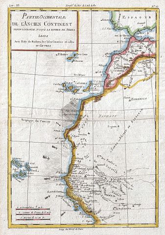
English: A fine example of Rigobert Bonne and G. Raynal’s 1780 map of Western Africa. This area corresponds to modern day Morocco, Western Sahara, Mauritania, and Algeria. Includes the Canary Islands, Madeira Island, and Cape Verde Islands. Offers minimal inland detail reflecting the paucity of knowledge about the interior of the continent at the time. The exception is the Senegal and Gambia river valleys extending inland from Cape Verde, which at the time were just being mapped by explorers and missionaries. Arrows and hachures shows some o f the ocean currents and winds that made this region so difficult to davigate in the early days of African exploration. Drawn by R. Bonne for G. Raynal’s Atlas de Toutes les Parties Connues du Globe Terrestre, Dressé pour l'Histoire Philosophique et Politique des Établissemens et du Commerce des Européens dans les Deux Indes . |
||||||||||||||||||||||
| Date | 1780 (undated) | ||||||||||||||||||||||
| Dimensions | height: 13 in (33 cm); width: 9 in (22.8 cm) | ||||||||||||||||||||||
| Accession number |
Geographicus link: AncienContinent-bonne-1780 |
||||||||||||||||||||||
| Source/Photographer |
Raynal, G., Atlas de Toutes les Parties Connues du Globe Terrestre, Dressé pour l'Histoire Philosophique et Politique des Établissemens et du Commerce des Européens dans les Deux Indes, 1780.
|
||||||||||||||||||||||
| Permission (Reusing this file) |
|
||||||||||||||||||||||
File history
Click on a date/time to view the file as it appeared at that time.
| Date/Time | Thumbnail | Dimensions | User | Comment | |
|---|---|---|---|---|---|
| current | 08:34, 24 March 2011 | | 1,756 × 2,500 (1.2 MB) | BotMultichillT (talk | contribs) | {{subst:User:Multichill/Geographicus |link=http://www.geographicus.com/P/AntiqueMap/AncienContinent-bonne-1780 |product_name=1780 Raynal and Bonne Map of Western Africa |map_title=Partie Occidentale De L'Ancien Continent |description=A fine example of Rig |
You cannot overwrite this file.
File usage on Commons
The following 2 pages use this file: