File:1818 Pinkerton Map of the Northern United States - Geographicus - USANorthernPart-pinkerton-1818.jpg

Size of this preview: 800 × 587 pixels. Other resolutions: 320 × 235 pixels | 640 × 470 pixels | 1,024 × 752 pixels | 1,280 × 940 pixels | 2,560 × 1,879 pixels | 5,000 × 3,670 pixels.
Original file (5,000 × 3,670 pixels, file size: 4.69 MB, MIME type: image/jpeg)
Captions
Captions
Add a one-line explanation of what this file represents
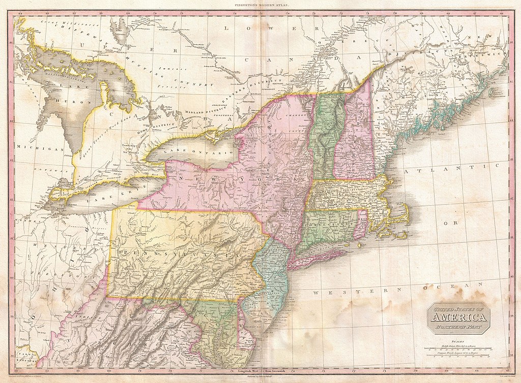
| John Pinkerton: United States of America Northern Part.
( |
|||||||||||||||||||||
|---|---|---|---|---|---|---|---|---|---|---|---|---|---|---|---|---|---|---|---|---|---|
| Artist |
|
||||||||||||||||||||
| Title |
United States of America Northern Part. |
||||||||||||||||||||
| Description |
English: John Pinkerton's highly decorative and important map of the northern parts of the United States, published 1818. Covers from Lake Huron eastward as far as New Brunswick and southwards as far as the Chesapeake Bay. Includes the states of New York, New Jersey, Pennsylvania, Connecticut, Rhode Island, Vermont, New Hampshire, Maryland, Delaware and Virginia. Also includes the districts of Maine, parts of the Western Territory, including Michigan and Ohio, and adjacent portions of Canada. Pinkerton's map is full of interesting detail from the American Indian lands in the western portions of the map, to notations on river navigation, to the configuration of the early states. Notes Connecticut's Western reserve in what is today Ohio. This territory was a legacy of Connecticut's original coast to coast charter and we settled in the early 19th century by New England emigrants. Drawn by L. Herbert and engraved by Samuel Neele under the direction of John Pinkerton. This map comes from the scarce American edition of Pinkerton’s Modern Atlas, published by Thomas Dobson & Co. of Philadelphia in 1818. |
||||||||||||||||||||
| Date | 1818 (undated) | ||||||||||||||||||||
| Dimensions | height: 20.5 in (52 cm); width: 28 in (71.1 cm) | ||||||||||||||||||||
| Accession number |
Geographicus link: USANorthernPart-pinkerton-1818 |
||||||||||||||||||||
| Source/Photographer |
Pinkerton, J., A Modern Atlas, from the Lates and Best Authorities, Exhibiting the Various Divisions of the World with its chief Empires, Kingdoms, and States; in Sixty Maps, carefully reduced from the Larges and Most Authentic Sources. 1818, Philadelphia, Thomas Dobson Edition.
|
||||||||||||||||||||
| Permission (Reusing this file) |
|
||||||||||||||||||||

File history
Click on a date/time to view the file as it appeared at that time.
| Date/Time | Thumbnail | Dimensions | User | Comment | |
|---|---|---|---|---|---|
| current | 06:54, 23 March 2011 | | 5,000 × 3,670 (4.69 MB) | BotMultichillT (talk | contribs) | {{subst:User:Multichill/Geographicus |link=http://www.geographicus.com/P/AntiqueMap/USANorthernPart-pinkerton-1818 |product_name=1818 Pinkerton Map of the Northern United States |map_title=United States of America Northern Part. |description=John Pinkerto |
You cannot overwrite this file.
File usage on Commons
The following page uses this file:
File usage on other wikis
The following other wikis use this file:
- Usage on es.wikipedia.org