File:1818 Pinkerton Map of the Southeastern United States, Carolina, Georgia, Virginia - Geographicus - USASouthernPart-pinkerton-1818.jpg
Size of this preview: 800 × 586 pixels. Other resolutions: 320 × 234 pixels | 640 × 469 pixels | 1,024 × 750 pixels | 1,280 × 938 pixels | 2,560 × 1,876 pixels | 5,000 × 3,664 pixels.
Original file (5,000 × 3,664 pixels, file size: 4.77 MB, MIME type: image/jpeg)
Captions
Captions
Add a one-line explanation of what this file represents
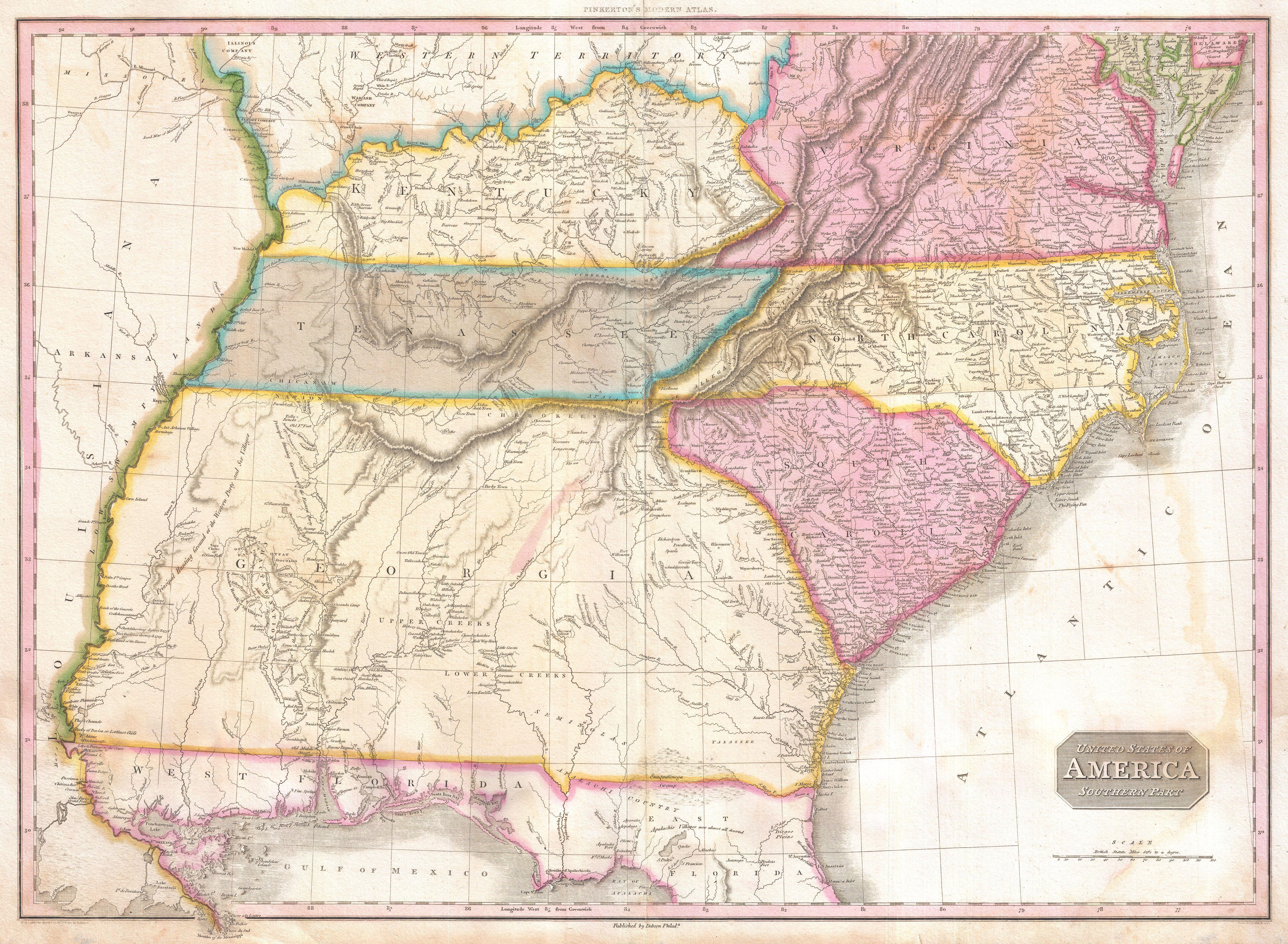
| John Pinkerton: United States of America Southern Part.
( |
|||||||||||||||||||||
|---|---|---|---|---|---|---|---|---|---|---|---|---|---|---|---|---|---|---|---|---|---|
| Artist |
|
||||||||||||||||||||
| Title |
United States of America Southern Part. |
||||||||||||||||||||
| Description |
English: A rare and important 1818 map of the southeastern part of the United States. Depicts from the Mississippi River eastward to the Pacific, extends north as far as Delaware and south as far as Florida and the Mississippi Delta. This map was created during the transitional period of expansion shortly following the American Revolutionary War. Shows Virginia, Kentucky, Tennessee, North Carolina, South Carolina and Georgia. Predates the formation of Ohio, Illinois, Indiana and Alabama. Florida was not yet part of the United States but would join one year after this map was printed in 1819. Most of this map is given over to describing and notating the various American Indian nations active west of the Appellation Mountains. Notes the Creeks, the Seminoles, the Apalachi, the Choctaw, the Chickasaw, and others. Hunting grounds, villages and fortifications are noted, sometimes accompanied by the date in which they were destroyed. Also identifies the Wabash Company, the Jersey Company and the Illinois Company. These land companies were formed during the colonial period to acquire, sell, and colonize American Indian lands just east of the Mississippi. Drawn by L. Herbert and engraved by Samuel Neele under the direction of John Pinkerton. The map comes from the scarce American edition of Pinkerton’s Modern Atlas, published by Thomas Dobson & Co. of Philadelphia in 1818. |
||||||||||||||||||||
| Date | 1818 (undated) | ||||||||||||||||||||
| Dimensions | height: 21 in (53.3 cm); width: 28 in (71.1 cm) | ||||||||||||||||||||
| Accession number |
Geographicus link: USASouthernPart-pinkerton-1818 |
||||||||||||||||||||
| Source/Photographer |
Pinkerton, J., A Modern Atlas, from the Lates and Best Authorities, Exhibiting the Various Divisions of the World with its chief Empires, Kingdoms, and States; in Sixty Maps, carefully reduced from the Larges and Most Authentic Sources. 1818, Philadelphia, Thomas Dobson Edition.
|
||||||||||||||||||||
| Permission (Reusing this file) |
|
||||||||||||||||||||

File history
Click on a date/time to view the file as it appeared at that time.
| Date/Time | Thumbnail | Dimensions | User | Comment | |
|---|---|---|---|---|---|
| current | 05:30, 23 March 2011 | | 5,000 × 3,664 (4.77 MB) | BotMultichillT (talk | contribs) | {{subst:User:Multichill/Geographicus |link=http://www.geographicus.com/P/AntiqueMap/USASouthernPart-pinkerton-1818 |product_name=1818 Pinkerton Map of the Southeastern United States: Carolina, Georgia, Virginia |map_title=United States of America Southern |
You cannot overwrite this file.
File usage on Commons
The following page uses this file: