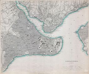
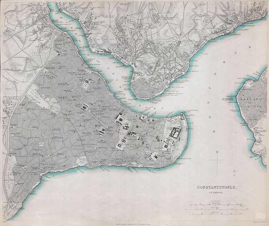
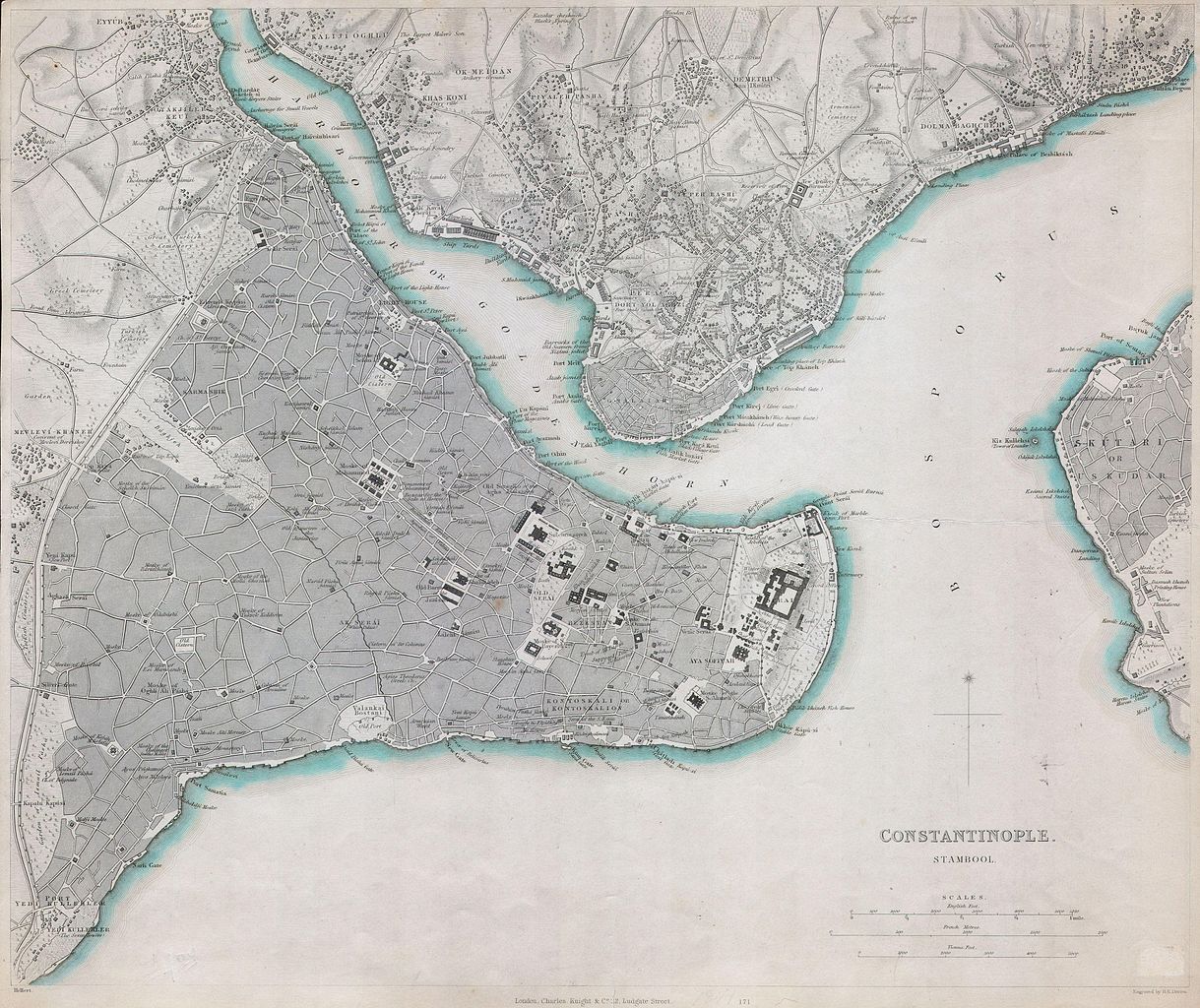
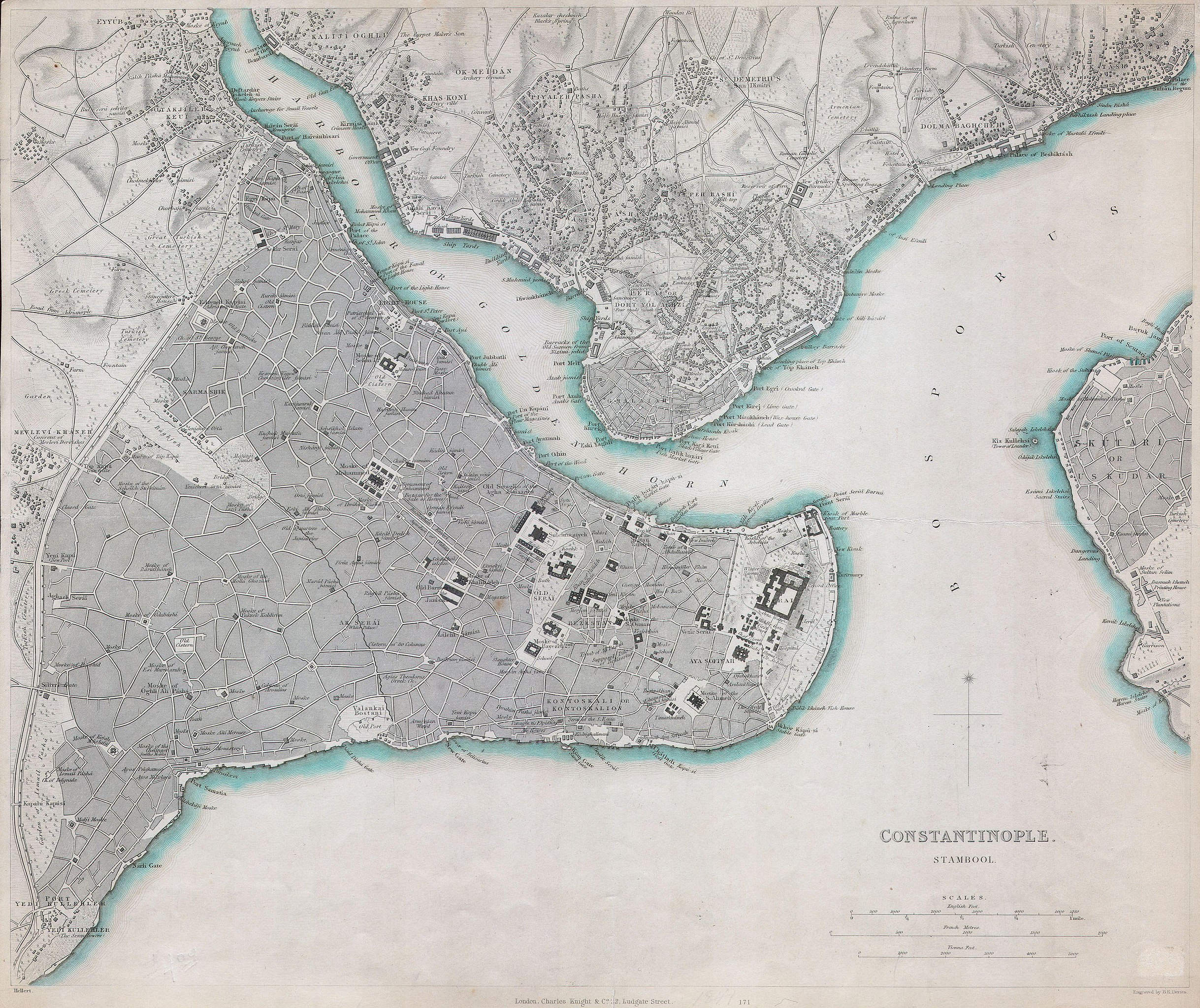
File:1840 S.D.U.K. Map of Constantinople ( Istanbul, Turkey ) - Geographicus - Istanbul-sduk-1841.jpg

Original file (4,000 × 3,361 pixels, file size: 2.81 MB, MIME type: image/jpeg)
Captions
Captions
| Constantinople. Stambool. | ||||||
|---|---|---|---|---|---|---|
| Artist | ||||||
| Title |
Constantinople. Stambool. |
|||||
| Description |
English: This map is a steel plate engraving, dating to 1841 by the Society for the Diffusion of Useful Knowledge, S.D.U.K. It represents the Constantinople (Stambool), today known as Istanbul and once known as Byzantium. Beautifully exhibits the Golden Horn with neighbouring Ghalatah, and Constantinople’s Asian part ‘Üskudar’. Depicts the city in considerable detail down to individual streets, markets, mosques, buildings and palaces. Published for the Society for the Diffusion of Useful Knowledge Atlas by Charles Knight of 22 Ludgate Street, London, 1841. |
|||||
| Date | 1841 | |||||
| Dimensions | height: 13 in (33 cm); width: 15.5 in (39.3 cm) | |||||
| Accession number |
Geographicus link: Istanbul-sduk-1841 |
|||||
| Source/Photographer |
Maps of the Society for the Diffusion of Useful Knowledge. Vol1. 1844.
|
|||||
| Permission (Reusing this file) |
|
|||||
File history
Click on a date/time to view the file as it appeared at that time.
| Date/Time | Thumbnail | Dimensions | User | Comment | |
|---|---|---|---|---|---|
| current | 06:47, 16 March 2011 | | 4,000 × 3,361 (2.81 MB) | BotMultichill (talk | contribs) | {{subst:User:Multichill/Geographicus |link=http://www.geographicus.com/P/AntiqueMap/Istanbul-sduk-1841 |product_name=1840 S.D.U.K. Map of Constantinople ( Istanbul, Turkey ) |map_title=Constantinople. Stambool. |description=This map is a steel plate engra |
You cannot overwrite this file.
File usage on Commons
The following 3 pages use this file:
_-_Geographicus_-_Istanbul-sduk-1841.jpg)
File usage on other wikis
The following other wikis use this file:
- Usage on it.wikipedia.org
- Usage on la.wikipedia.org
_-_Geographicus_-_Istanbul-sduk-1841.jpg&oldid=744969765)