File:1852 Levasseur Map of the Department De La Charente Maritime - Geographicus - CharenteInf-levasseur-1852.jpg
Size of this preview: 415 × 599 pixels. Other resolutions: 166 × 240 pixels | 333 × 480 pixels | 532 × 768 pixels | 710 × 1,024 pixels | 2,426 × 3,500 pixels.
Original file (2,426 × 3,500 pixels, file size: 2.92 MB, MIME type: image/jpeg)
Captions
Captions
Add a one-line explanation of what this file represents
| Dept. de la Charente Infre. | ||||||||||||||||||||||||||||||||||||
|---|---|---|---|---|---|---|---|---|---|---|---|---|---|---|---|---|---|---|---|---|---|---|---|---|---|---|---|---|---|---|---|---|---|---|---|---|
| Artist |
|
|||||||||||||||||||||||||||||||||||
| Title |
Dept. de la Charente Infre. |
|||||||||||||||||||||||||||||||||||
| Description |
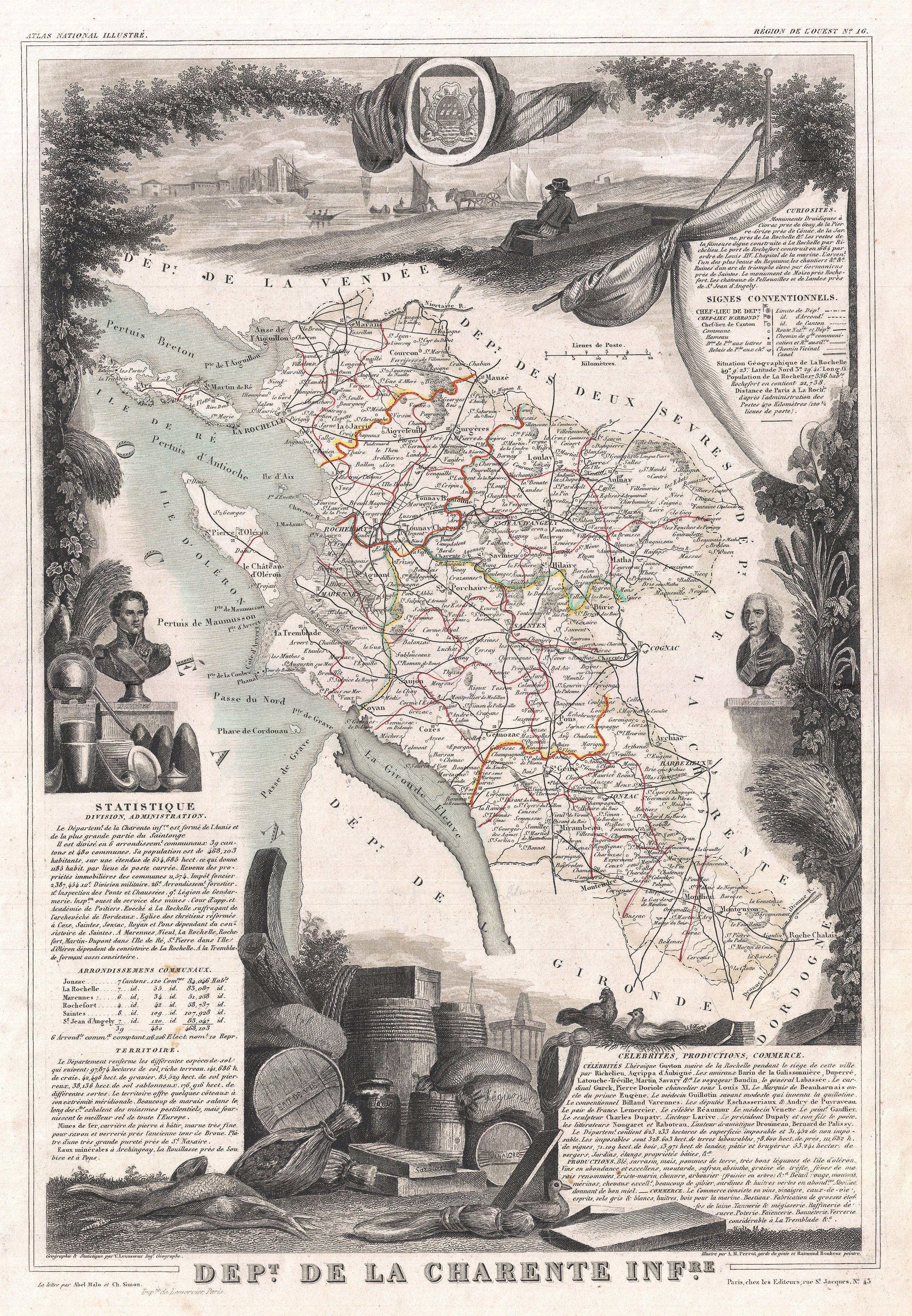
English: This is a fascinating 1852 map of the French department of Charente Inférieure (Charente Maritime), France. Charente Maritime is a coastal province border Charente, Dordogne, and Gironde (Bordeaux). It is best known as the producer of the world's finest Cognacs. The map proper is surrounded by elaborate decorative engravings designed to illustrate both the natural beauty and trade richness of the land. There is a short textual history of the regions depicted on both the left and right sides of the map. Published by V. Levasseur in the 1852 edition of his Atlas National de la France Illustree.
Français : Il s'agit d'une carte de 1852 du département français de la Charente-Inférieure (ancien nom de la Charente-Maritime). La Charente-Maritime est un département côtier. Il est surtout connu comme le producteur des meilleurs cognacs, au monde. La carte est décorée de gravures qui illustrent la beauté et la richesse naturelle du commerce de la terre. Il y a une courte histoire textuelle des régions représentées sur les côtés gauche et droit de la carte. Publiée par Victor Levasseur dans l'édition 1852 de son Atlas National Illustré de France. |
|||||||||||||||||||||||||||||||||||
| Date | 1852 | |||||||||||||||||||||||||||||||||||
| Dimensions | height: 17 in (43.1 cm); width: 11.5 in (29.2 cm) | |||||||||||||||||||||||||||||||||||
| Accession number |
Geographicus link: CharenteInf-levasseur-1852 |
|||||||||||||||||||||||||||||||||||
| Source/Photographer |
Levassuer, V., Atlas National Illustre des 86 Departements et des Possessions de La France Divise par Arrondissements, Cantons et Communea avec La Trace de Toutes Les Routes, Chemins,de fer et Canaux., 1852 edition.
|
|||||||||||||||||||||||||||||||||||
| Permission (Reusing this file) |
|
|||||||||||||||||||||||||||||||||||
File history
Click on a date/time to view the file as it appeared at that time.
| Date/Time | Thumbnail | Dimensions | User | Comment | |
|---|---|---|---|---|---|
| current | 16:47, 24 March 2011 | | 2,426 × 3,500 (2.92 MB) | BotMultichillT (talk | contribs) | {{subst:User:Multichill/Geographicus |link=http://www.geographicus.com/P/AntiqueMap/CharenteInf-levasseur-1852 |product_name=1852 Levasseur Map of the Department De La Charente Maritime |map_title=Dept. de la Charente Infre. |description=This is a fascina |
You cannot overwrite this file.
File usage on Commons
The following page uses this file:
File usage on other wikis
The following other wikis use this file:
- Usage on fr.wikipedia.org