File:1852 Levasseur Map of the Department De La Vendee, France (Fiefs Vendéens Wines) - Geographicus - Vendee-levasseur-1852.jpg
Size of this preview: 800 × 568 pixels. Other resolutions: 320 × 227 pixels | 640 × 454 pixels | 1,024 × 727 pixels | 1,280 × 909 pixels | 2,560 × 1,818 pixels | 3,500 × 2,485 pixels.
Original file (3,500 × 2,485 pixels, file size: 2.89 MB, MIME type: image/jpeg)
Captions
Captions
Add a one-line explanation of what this file represents
| Dept. de la Vendee. | ||||||||||||||||||||||||||||||||||||
|---|---|---|---|---|---|---|---|---|---|---|---|---|---|---|---|---|---|---|---|---|---|---|---|---|---|---|---|---|---|---|---|---|---|---|---|---|
| Artist |
|
|||||||||||||||||||||||||||||||||||
| Title |
Dept. de la Vendee. |
|||||||||||||||||||||||||||||||||||
| Description |
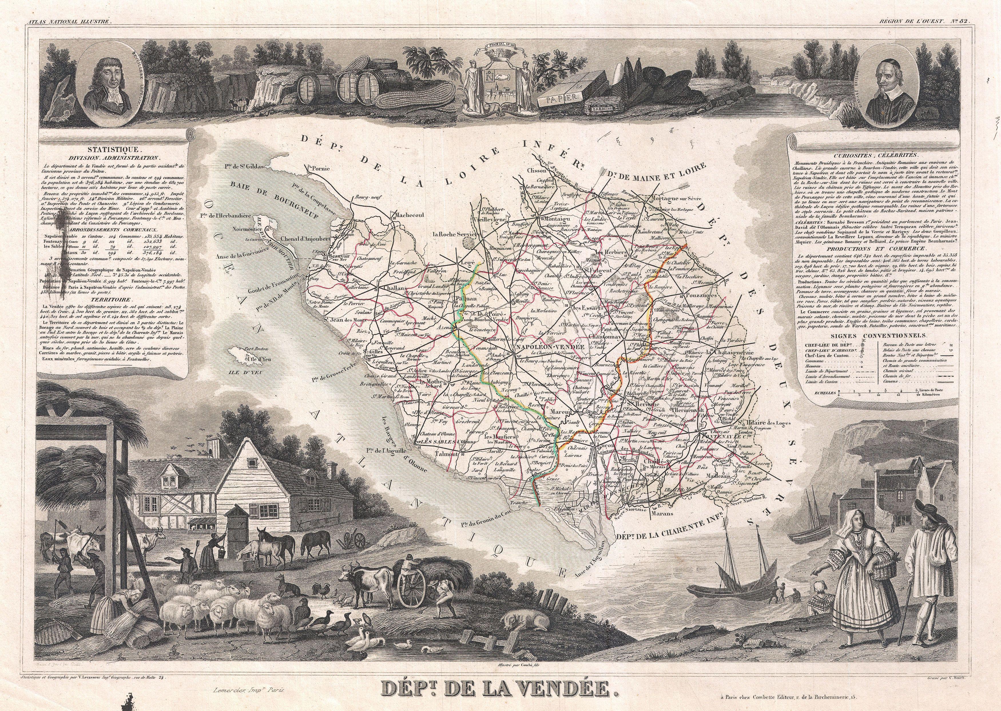
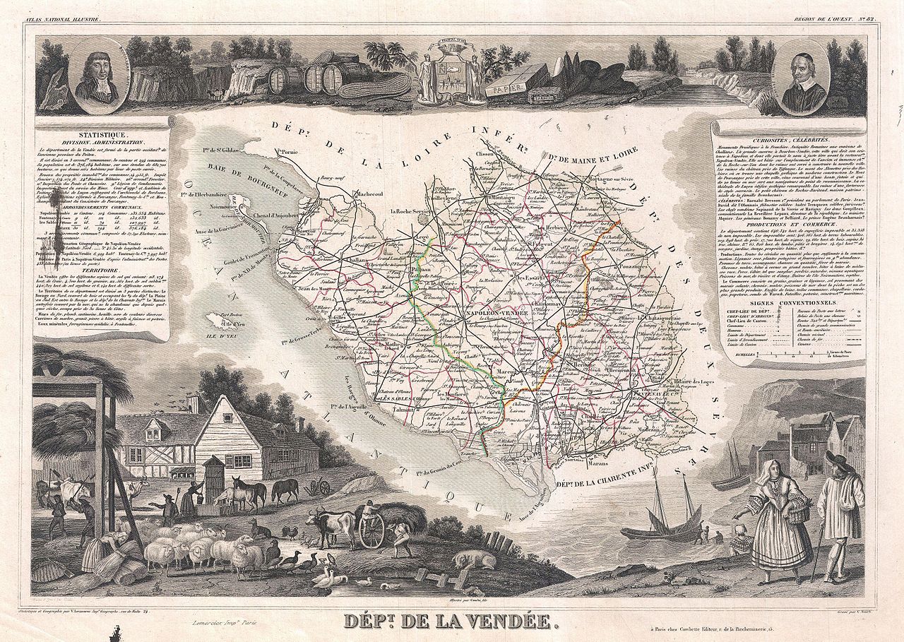
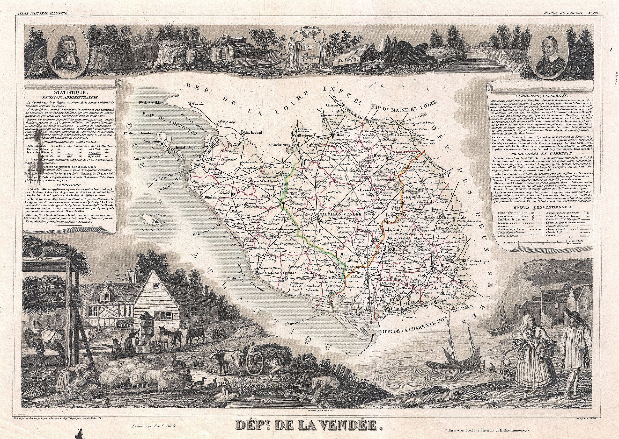
English: This is a fascinating 1852 map of the French department of Vendee, France. Vendee is home to a number of small vineyards around the communes of Vix, Brem, Pissotte and Mareuil-sur-Lay. These wines are marketed under the Fiefs Vendéens designation. Production quality has improved markedly over recent years, and, having already achieved the classification Vin Délimité de Qualité Supérieure (VDQS), the wines are on their way towards A.O.C status (Appellation d’Origine Contrôlée). The map proper is surrounded by elaborate decorative engravings designed to illustrate both the natural beauty and trade richness of the land. There is a short textual history of the regions depicted on both the left and right sides of the map. Published by V. Levasseur in the 1852 edition of his Atlas National de la France Illustree. |
|||||||||||||||||||||||||||||||||||
| Date | 1852 (undated) | |||||||||||||||||||||||||||||||||||
| Dimensions | height: 11.5 in (29.2 cm); width: 16.5 in (41.9 cm) | |||||||||||||||||||||||||||||||||||
| Accession number |
Geographicus link: Vendee-levasseur-1852 |
|||||||||||||||||||||||||||||||||||
| Source/Photographer |
Levassuer, V., Atlas National Illustre des 86 Departements et des Possessions de La France Divise par Arrondissements, Cantons et Communea avec La Trace de Toutes Les Routes, Chemins,de fer et Canaux., 1852 edition.
|
|||||||||||||||||||||||||||||||||||
| Permission (Reusing this file) |
|
|||||||||||||||||||||||||||||||||||
File history
Click on a date/time to view the file as it appeared at that time.
| Date/Time | Thumbnail | Dimensions | User | Comment | |
|---|---|---|---|---|---|
| current | 06:06, 24 March 2011 | | 3,500 × 2,485 (2.89 MB) | BotMultichillT (talk | contribs) | {{subst:User:Multichill/Geographicus |link=http://www.geographicus.com/P/AntiqueMap/Vendee-levasseur-1852 |product_name=1852 Levasseur Map of the Department De La Vendee, France (Fiefs Vendéens Wines) |map_title=Dept. de la Vendee. |description=This is a |
You cannot overwrite this file.
File usage on Commons
The following page uses this file:
_-_Geographicus_-_Vendee-levasseur-1852.jpg)
File usage on other wikis
The following other wikis use this file:
- Usage on fr.wikipedia.org
_-_Geographicus_-_Vendee-levasseur-1852.jpg&oldid=760506014)