File:1860 James Polar Projection of the Globe - Antarctica - Pacific Center - Geographicus - AntarcticProjection-james-1860.jpg

Original file (3,426 × 3,408 pixels, file size: 1.97 MB, MIME type: image/jpeg)
Captions
Captions
| Geometrical Projection of Two Thirds of the Sphere by Col. Sir H. James, R.E.F.R.S: M.R.I.A: & c. | ||||||
|---|---|---|---|---|---|---|
| Artist | ||||||
| Title |
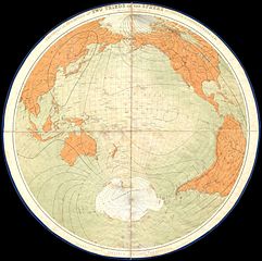
Geometrical Projection of Two Thirds of the Sphere by Col. Sir H. James, R.E.F.R.S: M.R.I.A: & c. |
|||||
| Description |
English: This is a scarce and unusual hand colored map is an projection of to thirds of the earth centered on the pacific ocean and the polar Antarctic regions. Dates roughly to 1860. Antarctica itself is indication but not shown as it had yet to be fully defined as a landmass. Printed in a highly unorthodox circular style and divided into four linen mounted sheets. Prepared by Colonel Sir Henry James. A rare and peculiar piece. |
|||||
| Date | 1860 | |||||
| Dimensions | height: 27 in (68.5 cm); width: 27 in (68.5 cm) | |||||
| Accession number |
Geographicus link: AntarcticProjection-james-1860 |
|||||
| Source/Photographer |
|
|||||
| Permission (Reusing this file) |
|
|||||
File history
Click on a date/time to view the file as it appeared at that time.
| Date/Time | Thumbnail | Dimensions | User | Comment | |
|---|---|---|---|---|---|
| current | 01:37, 25 March 2011 | | 3,426 × 3,408 (1.97 MB) | BotMultichillT (talk | contribs) | {{subst:User:Multichill/Geographicus |link=http://www.geographicus.com/P/AntiqueMap/AntarcticProjection-james-1860 |product_name=1860 James Polar Projection of the Globe - Antarctica / Pacific Center |map_title=Geometrical Projection of Two Thirds of the |
You cannot overwrite this file.
File usage on Commons
The following page uses this file: