File:1864 Johnson Map of Washington, Oregon, and Idaho - Geographicus - OregonWashingtonIdaho-johnson-1864.jpg

Size of this preview: 748 × 599 pixels. Other resolutions: 300 × 240 pixels | 599 × 480 pixels | 959 × 768 pixels | 1,278 × 1,024 pixels | 2,556 × 2,048 pixels | 3,500 × 2,804 pixels.
Original file (3,500 × 2,804 pixels, file size: 2.99 MB, MIME type: image/jpeg)
Captions
Captions
Add a one-line explanation of what this file represents
| Alvin Jewett Johnson: Johnson's Washington Oregon and Idaho.
( |
|||||||||||||||||||||||
|---|---|---|---|---|---|---|---|---|---|---|---|---|---|---|---|---|---|---|---|---|---|---|---|
| Artist |
|
||||||||||||||||||||||
| Title |
Johnson's Washington Oregon and Idaho. |
||||||||||||||||||||||
| Description |
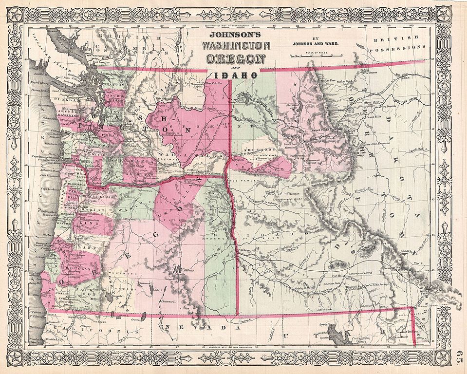
English: This is A. J. Johnson’s beautifully hand colored first edition 1864 map of Washington, Oregon, and Idaho, with parts of modern day Montana and Wyoming. This map shows cities, topographical features, railways, ferries and roads with color coding at the county level. Additionally shows important mountain passes, the route of famous explores including Fremont (1843), and the ill-conceived Stevens route for the Pacific Railroad. The origins of this map can be traced to Johnson’s acquisition of J. H. Colton’s c. 1855 map plates. Due to the rapidly changing political situation in the Pacific Northwest during the middle part of the 19th century, Johnson was forced to update his map of this region on an annual and sometimes semi-annual basis, thus making all editions extremely ephemeral. This example follows the consolidation of Washington’s western border and the creation of somewhat indistinct Idaho and Dakota territories. It also predates the exploration of the stunning Yellowstone Valley. Published by A. J. Johnson and Ward as plate no. 65 in the 1864 edition of Johnson’s New Illustrated Family Atlas . This is the first edition of the Johnson’s Atlas to bear the Johnson & Ward imprint and the only edition to identify the firm as the “Successors to Johnson and Browning (Successors to J. H. Colton and Company)”. |
||||||||||||||||||||||
| Date | 1864 (undated) | ||||||||||||||||||||||
| Dimensions | height: 13 in (33 cm); width: 16 in (40.6 cm) | ||||||||||||||||||||||
| Accession number |
Geographicus link: OregonWashingtonIdaho-johnson-1864 |
||||||||||||||||||||||
| Source/Photographer |
Johnson, A. J., Johnson's New Illustrated (Steel Plate) Family Atlas of The World with Physical Geography, and with Descriptions Geographical, Statistical, and Historic including The Latest Federal Census, A Geographical Index, and a Chronological History of the Civil War in America, (first Johnson and Ward), 1864.
|
||||||||||||||||||||||
| Permission (Reusing this file) |
|
||||||||||||||||||||||
File history
Click on a date/time to view the file as it appeared at that time.
| Date/Time | Thumbnail | Dimensions | User | Comment | |
|---|---|---|---|---|---|
| current | 01:50, 25 March 2011 | | 3,500 × 2,804 (2.99 MB) | BotMultichillT (talk | contribs) | {{subst:User:Multichill/Geographicus |link=http://www.geographicus.com/P/AntiqueMap/OregonWashingtonIdaho-johnson-1864 |product_name=1864 Johnson Map of Washington, Oregon, and Idaho |map_title=Johnson's Washington Oregon and Idaho. |description=This is A |
You cannot overwrite this file.
File usage on Commons
The following page uses this file: