File:1864 Johnson Map of Washington D.C. and Georgetown - Geographicus - WashingtonDC-johnson-1864.jpg
Size of this preview: 743 × 600 pixels. Other resolutions: 297 × 240 pixels | 595 × 480 pixels | 951 × 768 pixels | 1,268 × 1,024 pixels | 2,537 × 2,048 pixels | 3,500 × 2,826 pixels.
Original file (3,500 × 2,826 pixels, file size: 3.2 MB, MIME type: image/jpeg)
Captions
Captions
Add a one-line explanation of what this file represents
| Alvin Jewett Johnson: Johnson's Georgetown and the City of Washington the Capital of the United States of America.
( |
|||||||||||||||||||||||
|---|---|---|---|---|---|---|---|---|---|---|---|---|---|---|---|---|---|---|---|---|---|---|---|
| Artist |
|
||||||||||||||||||||||
| Title |
Johnson's Georgetown and the City of Washington the Capital of the United States of America. |
||||||||||||||||||||||
| Description |
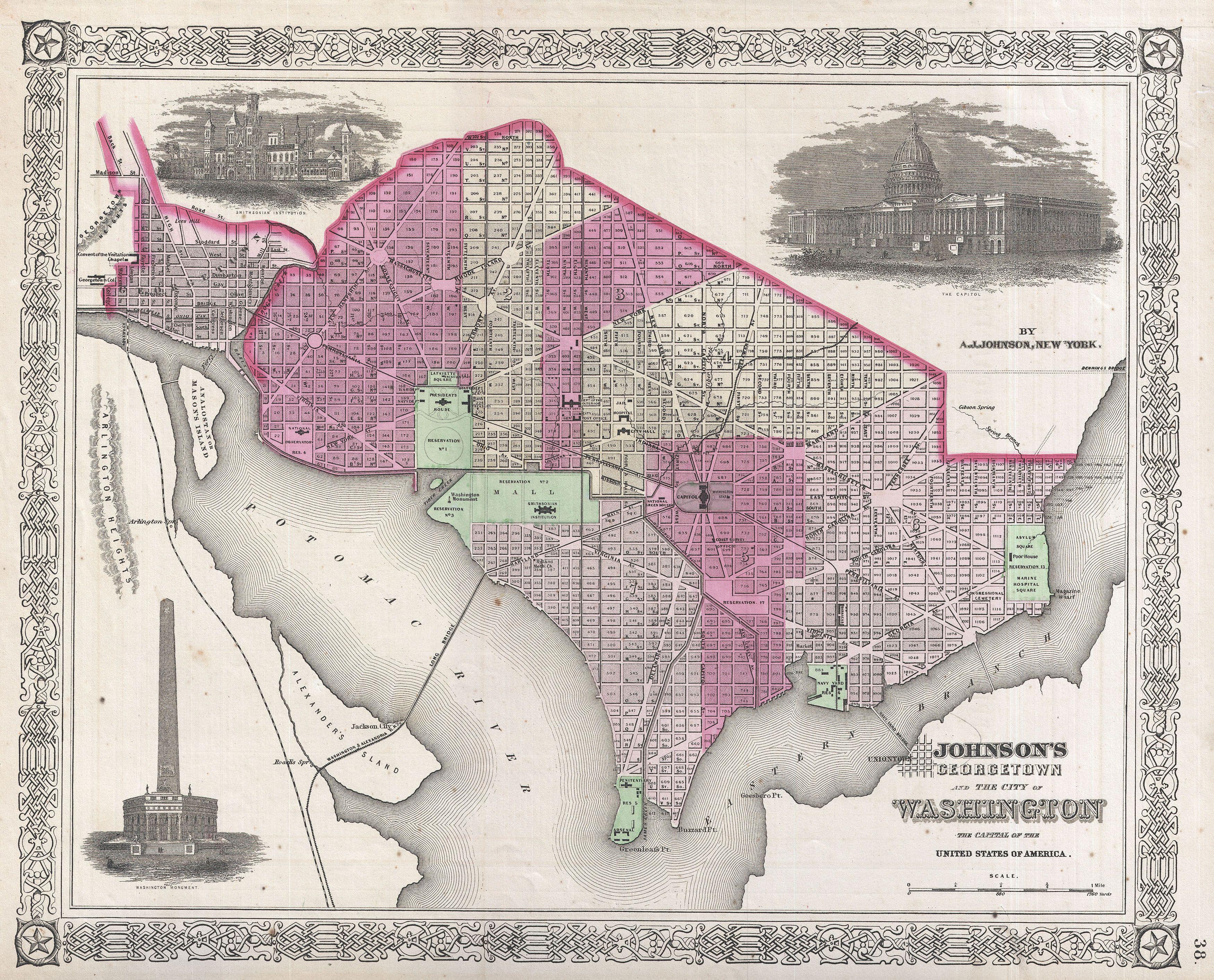
English: A beautiful example of A. J. Johnson’s 1864 map of Washington D.C. and Georgetown. Offers a fascinating snapshot of the nation’s capitol shortly after the outbreak of the American Civil War. Shows the city in considerable detail with color coding according to ward. Notes numerous important buildings including the Capitol, the Smithsonian Institution, the White House (not yet called the White House), the Washington Monument, the National Observatory, the Naval Yard, the Poor House, the City Hall, and others. Shows the grid and ray structure according to L’Enfant's brilliant plan. Georgetown appears as a separate entity in the upper left corner with Georgetown College noted just outside the city border. Also shows proposed landfills and extensions to the east side of the city into the east branch of the Potomac River. The grand dome of the Capitol Building, shown complete in the upper right hand quadrant of this map, was only partially complete when this map was issued. The Washington Monument appears in an earlier unrealized conceptualization in the lower left quadrant. The Smithsonian Institution, now the nation's largest museum, is pictured in the upper left quadrant. Features the fretwork style border common to Johnson’s atlas work from 1864 to 1869. Published by A. J. Johnson and Ward as plate number 37 in the 1864 edition of Johnson’s New Illustrated Family Atlas . This is the first edition of Johnson’s Atlas to bear the “Johnson and Ward” imprint. |
||||||||||||||||||||||
| Date | 1864 (undated) | ||||||||||||||||||||||
| Dimensions | height: 13 in (33 cm); width: 16 in (40.6 cm) | ||||||||||||||||||||||
| Accession number |
Geographicus link: WashingtonDC-johnson-1864 |
||||||||||||||||||||||
| Source/Photographer |
Johnson, A. J., Johnson's New Illustrated (Steel Plate) Family Atlas with Descriptions, Geographical, Statistical, and Historical. (1865 A. J. Johnson edition)
|
||||||||||||||||||||||
| Permission (Reusing this file) |
|
||||||||||||||||||||||
File history
Click on a date/time to view the file as it appeared at that time.
| Date/Time | Thumbnail | Dimensions | User | Comment | |
|---|---|---|---|---|---|
| current | 04:06, 23 March 2011 | | 3,500 × 2,826 (3.2 MB) | BotMultichillT (talk | contribs) | {{subst:User:Multichill/Geographicus |link=http://www.geographicus.com/P/AntiqueMap/WashingtonDC-johnson-1864 |product_name=1864 Johnson Map of Washington D.C. and Georgetown |map_title=Johnson's Georgetown and the City of Washington the Capital of the Un |
You cannot overwrite this file.
File usage on Commons
The following page uses this file: