File:1864 Justus Perthes Comparative Mountains of the World Chart - Geographicus - ComparativeMountains-perthes-1864.jpg

Size of this preview: 769 × 599 pixels. Other resolutions: 308 × 240 pixels | 616 × 480 pixels | 985 × 768 pixels | 1,280 × 998 pixels | 2,560 × 1,995 pixels | 3,500 × 2,728 pixels.
Original file (3,500 × 2,728 pixels, file size: 2.22 MB, MIME type: image/jpeg)
Captions
Captions
Add a one-line explanation of what this file represents
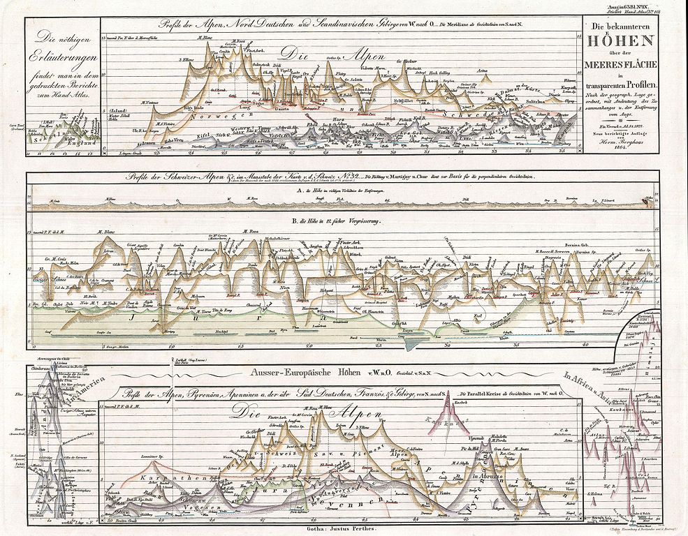
| Justus Perthes: Die becannteren Hoehen uber der Meeres Flache in Transparenten Profilen.
( |
||||||||||||||||||||||||
|---|---|---|---|---|---|---|---|---|---|---|---|---|---|---|---|---|---|---|---|---|---|---|---|---|
| Artist |
|
|||||||||||||||||||||||
| Title |
Die becannteren Hoehen uber der Meeres Flache in Transparenten Profilen. |
|||||||||||||||||||||||
| Description |
English: This German comparative mountains chart or map was issued by publisher Justus Perthes in 1864 and represents a style that evolved independently in Germany between 1840 and 1870. In this example mountains are shown in a transparent profile with multiple ranges overlapping. While the chart focuses on the Alps, which would have been significant to the Perthes audience, it also incorporates the mountains of America, Africa, and Asia, as well as the Caucuses, Scotland and England. While this excessively complex style of rendering comparative elevation never caught on outside of Germany, its sophisticated use of profile may have had an impact on the early 20th century comparative global elevation profiles that adorn the base of many modern school maps. Published by Justus Perthes in 1864 as plate no. 10 in Stieler's Hand Atlas . |
|||||||||||||||||||||||
| Date | 1864 (dated) | |||||||||||||||||||||||
| Dimensions | height: 12 in (30.4 cm); width: 15 in (38.1 cm) | |||||||||||||||||||||||
| Accession number |
Geographicus link: ComparativeMountains-perthes-1864 |
|||||||||||||||||||||||
| Source/Photographer |
Stieler, A., Stieler's Hand Atlas, 1864 edition.
|
|||||||||||||||||||||||
| Permission (Reusing this file) |
|
|||||||||||||||||||||||

File history
Click on a date/time to view the file as it appeared at that time.
| Date/Time | Thumbnail | Dimensions | User | Comment | |
|---|---|---|---|---|---|
| current | 04:51, 24 March 2011 | | 3,500 × 2,728 (2.22 MB) | BotMultichillT (talk | contribs) | {{subst:User:Multichill/Geographicus |link=http://www.geographicus.com/P/AntiqueMap/ComparativeMountains-perthes-1864 |product_name=1864 Justus Perthes Comparative Mountains of the World Chart |map_title=Die becannteren Hoehen uber der Meeres Flache in Tr |
You cannot overwrite this file.
File usage on Commons
The following page uses this file: