File:1868 Rogers Map of Manhattan, New York City (North of 86th St) - Geographicus - NYCHarlemHeights3-rogers-1868.jpg

Original file (4,000 × 2,518 pixels, file size: 3.26 MB, MIME type: image/jpeg)
Captions
Captions
| Map of the upper part of the Island of Manhattan above eighty-sixth street arranged to illustrate the Battle of Harlem Heights. | ||||||
|---|---|---|---|---|---|---|
| Artist | ||||||
| Title |
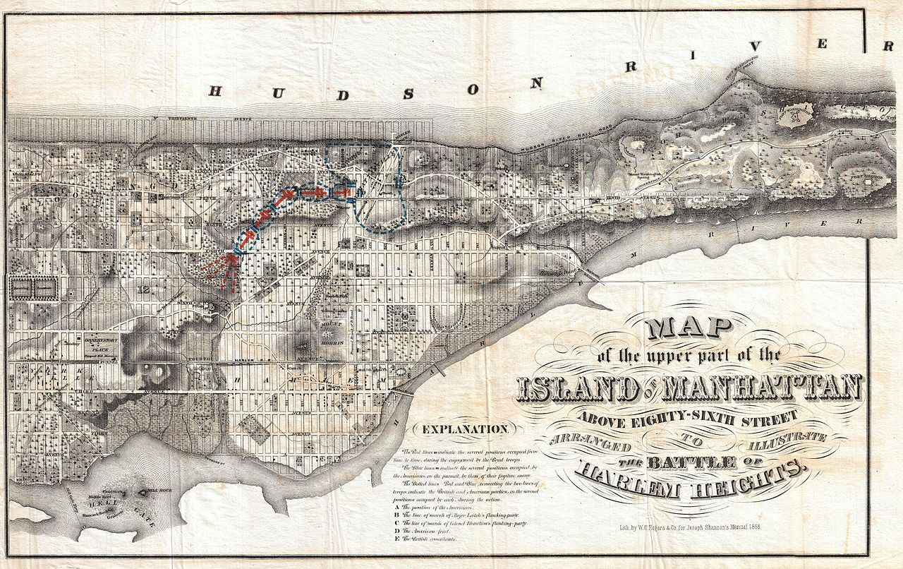
Map of the upper part of the Island of Manhattan above eighty-sixth street arranged to illustrate the Battle of Harlem Heights. |
|||||
| Description |
English: A stunning and rare 1868 Map of the northern part of the island of Manhattan, New York city by W. C. Rogers. Map covers the upper part of Manhattan, above 86th street (including Morningside Heights, Manhattan Valley, Harlem, Inwood, the Upper West Side, the Upper East Side, etc...) in extraordinary detail, depicting streets, buildings, estates and in many cases individual trees. This map is most certainly based upon the 1836 Topographical Map of the City and County of New York drawn by David H. Burr and published by J.H. Colton. Colton’s map was perhaps the “finest example of artistic mapmaking applied to the Island of Manhattan” (I.N. Phelps Stokes). This map uses only the northern portion of Colton’s map, but features the same stunning detail. Beautifully hand colored to illustrate the Battle of Harlem Heights. This is the best map of northern Manhattan that we are aware of. Prepared for inclusion in the 1868 edition of Joseph Shannon’s Manual Of The Corporation Of The City of New York . An important piece for collectors of New York City cartography. |
|||||
| Date | 1868 (dated) | |||||
| Dimensions | height: 15 in (38.1 cm); width: 23.5 in (59.6 cm) | |||||
| Accession number |
Geographicus link: NYCHarlemHeights3-rogers-1868 |
|||||
| Source/Photographer |
|
|||||
| Permission (Reusing this file) |
|
|||||
File history
Click on a date/time to view the file as it appeared at that time.
| Date/Time | Thumbnail | Dimensions | User | Comment | |
|---|---|---|---|---|---|
| current | 08:43, 24 March 2011 | | 4,000 × 2,518 (3.26 MB) | BotMultichillT (talk | contribs) | {{subst:User:Multichill/Geographicus |link=http://www.geographicus.com/P/AntiqueMap/NYCHarlemHeights3-rogers-1868 |product_name=1868 Rogers Map of Manhattan, New York City (North of 86th St) |map_title=Map of the upper part of the Island of Manhattan abov |
You cannot overwrite this file.
File usage on Commons
The following page uses this file:
_-_Geographicus_-_NYCHarlemHeights3-rogers-1868.jpg)
File usage on other wikis
The following other wikis use this file:
- Usage on en.wikipedia.org
_-_Geographicus_-_NYCHarlemHeights3-rogers-1868.jpg&oldid=804861765)