File:20070207850DR Dresden-Weißer Hirsch Standseilbahn Bergstation.jpg

Size of this preview: 774 × 599 pixels. Other resolutions: 310 × 240 pixels | 620 × 480 pixels | 992 × 768 pixels | 1,280 × 991 pixels | 2,402 × 1,860 pixels.
Original file (2,402 × 1,860 pixels, file size: 4.27 MB, MIME type: image/jpeg)
Captions
Captions
Add a one-line explanation of what this file represents
Summary
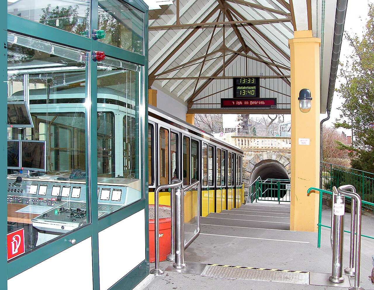
edit| Description |
Deutsch: 07.02.2007 01324 Dresden-Weißer Hirsch, Bergbahnstraße (GMP: 51.058441,13.818820). Oberer Haltepunkt der Standseilbahn. Eröffnet wurde sie mit Dampfbetrieb am 29.10.1895 von der Drahtseilbahn Loschwitz AG. 1909 wurde auf elektrischen Betrieb umgestellt. Auf einer Fahrstrecke von 547 m überwindet sie 94 m Höhenunterschied. Das bergwärtige und das talwärtige Fahrzeug begegnen sich auf dem Viadukt (GMP: 51.056490,13.816850) mit der Abtschen Weiche. Zwei Tunnel werden durchfahren: der Burgbergtunnel (96 m) und der Prinzeß-Louisa-Tunnel (54 m). In den Jahren 1978/79 war eine Generalsanierung erforderlich. Die Fördermaschine, der Prinzeß-Louisa-Tunnel und das Gerüstviadukt wurden instand gesetzt. Seit 1984 steht die Standseilbahn unter Denkmalschutz. Nach der Wende
erfolgte eine Modernisierung der gesamten Bahnanlage. Dabei erhielt die Bergstation einen Bedienstand am Bahnsteig, der den Arbeitsplatz des Maschinisten vom Keller ans Tageslicht verlagerte, und die Talstation eine neue lichtdurchlässige Dachkonstruktion. [DSCN20863.TIF]20070207850DR.JPG(c)Blobelt |
||||||||||||||
| Date | |||||||||||||||
| Source | Own work | ||||||||||||||
| Author |
|
||||||||||||||

| Camera location | | View this and other nearby images on: OpenStreetMap |
|---|
| Object location | | View this and other nearby images on: OpenStreetMap |
|---|
Licensing
edit
This file is licensed under the Creative Commons Attribution-Share Alike 4.0 International license.
- You are free:
- to share – to copy, distribute and transmit the work
- to remix – to adapt the work
- Under the following conditions:
- attribution – You must give appropriate credit, provide a link to the license, and indicate if changes were made. You may do so in any reasonable manner, but not in any way that suggests the licensor endorses you or your use.
- share alike – If you remix, transform, or build upon the material, you must distribute your contributions under the same or compatible license as the original.
File history
Click on a date/time to view the file as it appeared at that time.
| Date/Time | Thumbnail | Dimensions | User | Comment | |
|---|---|---|---|---|---|
| current | 20:53, 10 October 2023 | | 2,402 × 1,860 (4.27 MB) | Jörg Blobelt (talk | contribs) | Uploaded a work by {{Creator:Jörg Blobelt}} from {{own}} with UploadWizard |
You cannot overwrite this file.
File usage on Commons
The following 2 pages use this file: