File:20090607120DR Meusegast (Dohna) Rastplatz Zürner-Bank.jpg

Size of this preview: 800 × 539 pixels. Other resolutions: 320 × 216 pixels | 640 × 431 pixels | 1,024 × 690 pixels | 1,280 × 862 pixels | 2,560 × 1,724 pixels.
Original file (2,560 × 1,724 pixels, file size: 3.65 MB, MIME type: image/jpeg)
Captions
Captions
Add a one-line explanation of what this file represents
Summary
edit| Description |
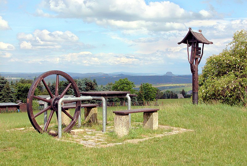
Deutsch: 07.06.2009 01809 Meusegast (Dohna): Rastplatz Zürner-Bank (GMP: 50.926650,13.870615) etwas abseits der Straße von Meusegast nach Burkhardswalde. Sie erinnert mit dem Vermessungsrad von Adam Friedrich Zürner an die sächsische Landvermessung. Auf August den Starken (1670-1733) geht die systematische Errichtung von Postmeilensäulen zurück. Er war es, der am 19. September 1721 den Befehl zur Aufstellung gab. Das gewaltige geodätische Projekt setzte der ehemalige Pfarrer Adam Friedrich Zürner (1679-1742) mit seinen Gehilfen um. Am Ende hatte Zürner eine Strecke von ca. 18.000 Meilen (163.116 km) allein für die Vermessung zurückgelegt. Im Hintergrund die Sächsische Schweiz mit dem Lilienstein. [DSCN37812.TIF]20090607120DR.JPG(c)Blobelt |
||||||||||||||
| Date | |||||||||||||||
| Source | Own work | ||||||||||||||
| Author |
|
||||||||||||||

_Rastplatz_Z%C3%BCrner-Bank.jpg&action=edit§ion=1)
| Object location | | View this and other nearby images on: OpenStreetMap |
|---|
_Rastplatz_Z%C3%BCrner-Bank.jpg¶ms=050.926650_N_0013.870615_E_globe:Earth_class:object_type:object__&language=en)
Licensing
edit_Rastplatz_Z%C3%BCrner-Bank.jpg&action=edit§ion=2)
This file is licensed under the Creative Commons Attribution-Share Alike 4.0 International license.
- You are free:
- to share – to copy, distribute and transmit the work
- to remix – to adapt the work
- Under the following conditions:
- attribution – You must give appropriate credit, provide a link to the license, and indicate if changes were made. You may do so in any reasonable manner, but not in any way that suggests the licensor endorses you or your use.
- share alike – If you remix, transform, or build upon the material, you must distribute your contributions under the same or compatible license as the original.
File history
Click on a date/time to view the file as it appeared at that time.
| Date/Time | Thumbnail | Dimensions | User | Comment | |
|---|---|---|---|---|---|
| current | 17:18, 17 October 2019 | | 2,560 × 1,724 (3.65 MB) | Jörg Blobelt (talk | contribs) | User created page with UploadWizard |
You cannot overwrite this file.
File usage on Commons
The following 2 pages use this file:
_Rastplatz_Zürner-Bank.jpg&oldid=799379732)