File:20140916 Oosterbroek 16 (Breegweestee) Eelde Dr NL.jpg

Size of this preview: 800 × 300 pixels. Other resolutions: 320 × 120 pixels | 640 × 240 pixels | 1,024 × 384 pixels | 1,280 × 480 pixels | 2,560 × 960 pixels | 7,200 × 2,700 pixels.
Original file (7,200 × 2,700 pixels, file size: 13.85 MB, MIME type: image/jpeg)
Captions
Captions
Add a one-line explanation of what this file represents
| Description |
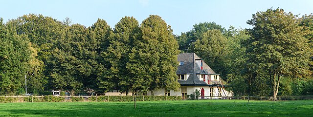
English: De Breegweestee, a drugs rehabilitation facility in Eelde, a village in the Dutch province of Drenthe. Originally consisting of two army barracks camouflaged as farms and a casemate, the complex was built in the early years of World War II by the Nazi-German Luftwaffe as part of defense works around the nearby Eelde Airport (called Fliegerhorst Eelde at the time). The Breegweestee is a provincial monument (PM2-0288). Frysk: De Breegweestee, in ôfkikklinyk yn it Drintske doarp Eelde. It komplex, dat oarspronklik bestie út twa as pleatsen kamûflearre legerbarakken en in kazemat, is yn de earste jierren fan de Twadde Wrâldkriich troch de Luftwaffe setten as part fan de Dútske ferdigingswurken om it Fleanfjild Eelde (doe Fliegerhorst Eelde neamd). De Breegweestee is in provinsjaal monumint (PM2-0288). Nederlands: De Breegweestee, een afkickkliniek in het Drentse dorp Eelde. Het complex, dat oorspronkelijk bestond uit twee als boerderijen gecamoufleerde legeringsgebouwen en een kazemat, werd in de eerste jaren van de Tweede Wereldoorlog gebouwd door de Luftwaffe als onderdeel van de Duitse verdedigingswerken rondom Vliegveld Eelde (toen Fliegerhorst Eelde genoemd). De Breegweestee is een provinciaal monument (PM2-0288).
|
||
| Date | |||
| Source | Own work | ||
| Author | |||
| Attribution (required by the license) | Wutsje / Wikimedia Commons / | ||
| Permission (Reusing this file) |
This file is licensed under the Creative Commons Attribution-Share Alike 3.0 Unported license.
|
| Camera location | | View this and other nearby images on: OpenStreetMap |
|---|
_Eelde_Dr_NL.jpg¶ms=053.131561_N_0006.591689_E_globe:Earth_type:camera_scale:2500_region:NL_heading:110.00&language=en)
File history
Click on a date/time to view the file as it appeared at that time.
| Date/Time | Thumbnail | Dimensions | User | Comment | |
|---|---|---|---|---|---|
| current | 20:14, 8 December 2014 | 7,200 × 2,700 (13.85 MB) | Wutsje (talk | contribs) | {{Information |Description = {{Multilingual description |en=De ''Breegweestee'', a drugs rehabilitation facility in Eelde, a village in the Dutch province of Drenthe. Originally consisting of two army barrac... |
You cannot overwrite this file.
File usage on Commons
The following 3 pages use this file:
_Eelde_Dr_NL.jpg&redirect=no)
File usage on other wikis
The following other wikis use this file:
- Usage on nl.wikipedia.org
- Usage on nl.wiktionary.org
_Eelde_Dr_NL.jpg&oldid=857824385)