File:3066Rizal, Nueva Ecija Barangays Roads Landmarks 07.jpg

Size of this preview: 800 × 600 pixels. Other resolutions: 320 × 240 pixels | 640 × 480 pixels | 1,024 × 768 pixels | 1,280 × 960 pixels | 2,560 × 1,920 pixels | 4,608 × 3,456 pixels.
Original file (4,608 × 3,456 pixels, file size: 6.93 MB, MIME type: image/jpeg)
Captions
Captions
Poblacion West, Rizal, Nueva Ecija
Summary
edit
| Description |
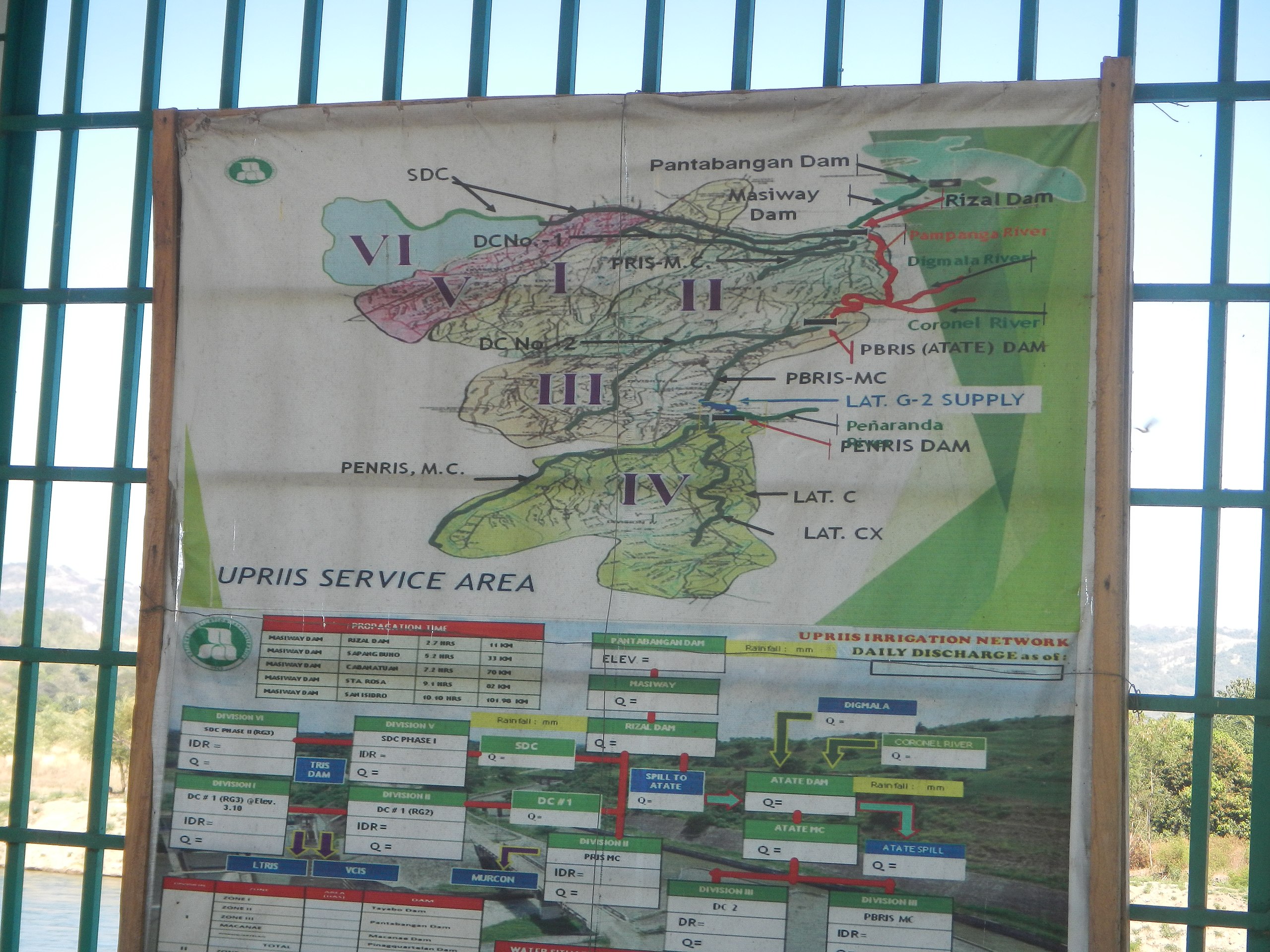
English: Casecnan Protected Landscape Casecnan River Casecnan Dam Poblacion West Bridge 2 - Irrigation, Rizal, Nueva Ecija Sitio Riverside, Rizal, Nueva Ecija National Irrigation Administration -Upper Pampanga River Integrated Irrigation System (NIA-UPRIIS) Pampanga River Irrigation System Pampanga River Irrigation System (Casecnan Project New Area Intake & Diversion Canal - Rizal Dam, Nueva Ecija) 29-kilometer superdiversion canal UPRIIS Irrigation Network Pampanga River Irrigation System (Casecnan Project New Area Intake & Diversion Canal - Rizal Dam, Nueva Ecija) - Sitios and Villages of Poblacion West National Irrigation Administration Poblacion West Bridge - Irrigation, Rizal, Nueva Ecija
Poblacion West, Rizal, Nueva Ecija Poblacion Central, Rizal, Nueva Ecija San Jose - Rizal Road (Rizal, Nueva Ecija section) San Jose - Rizal Road 15.9 kilometres 15°45'5.04" Longitude: 121°2'58.56" Poblacion West, Rizal, Nueva Ecija Saint Joseph the Husband Parish Church (Rizal, Nueva Ecija) Irrigation in Rizal, Nueva Ecija Category:Barangays of Nueva Ecija Barangay Poblacion Central, Rizal, Nueva Ecija 15.7093, 121.1048 Poblacion West, Rizal 15.7100, 121.0945 Rizal, Nueva Ecija from or along Junction Pinagpanaan-Rizal-Pantabangan Road (Pinagpanaan, Talavera-Llanera-Poblacion Norte, Rizal, Nueva Ecija) of the Junction Pinagpanaan-Rizal-Pantabangan Road 15°32'54"N 120°56'4"E Nueva Ecija length of 25.64 kilometres Pinagpanaan, Talavera 15.5536, 120.9489 Talavera, Nueva_Ecija to Llanera, Nueva Ecija Poblacion Norte, Rizal 15.7200, 121.1020 to Pantabangan, Nueva Ecija Philippine highway network (Note: Judge Florentino Floro, the owner, to repeat, Donor Florentino Floro of all these photos hereby donate gratuitously, freely and unconditionally Judge Floro all these photos to and for Wikimedia Commons, exclusively, for public use of the public domain, and again without any condition whatsoever). |
| Date | |
| Source | Own work |
| Author | Judgefloro |
| Camera location | | View this and other nearby images on: OpenStreetMap |
|---|
Poblacion West, Rizal 15.7100, 121.0945
Licensing
edit
I, the copyright holder of this work, hereby publish it under the following license:
| This file is made available under the Creative Commons CC0 1.0 Universal Public Domain Dedication. | |
| The person who associated a work with this deed has dedicated the work to the public domain by waiving all of their rights to the work worldwide under copyright law, including all related and neighboring rights, to the extent allowed by law. You can copy, modify, distribute and perform the work, even for commercial purposes, all without asking permission.
|
File history
Click on a date/time to view the file as it appeared at that time.
| Date/Time | Thumbnail | Dimensions | User | Comment | |
|---|---|---|---|---|---|
| current | 05:10, 4 March 2019 | | 4,608 × 3,456 (6.93 MB) | Judgefloro (talk | contribs) | User created page with UploadWizard |
You cannot overwrite this file.
File usage on Commons
There are no pages that use this file.