File:Atlas Van der Hagen-KW1049B13 097-PRAEFECTURAE DE PARAIBA, ET RIO GRANDE.jpeg
(Redirected from File:AMH-7743-KB Map of Paraiba and Rio Grande.jpg)
Size of this preview: 769 × 600 pixels. Other resolutions: 308 × 240 pixels | 615 × 480 pixels | 985 × 768 pixels | 1,280 × 999 pixels | 2,560 × 1,997 pixels | 5,500 × 4,291 pixels.
Original file (5,500 × 4,291 pixels, file size: 3.46 MB, MIME type: image/jpeg)
Captions
Captions
Add a one-line explanation of what this file represents
Summary edit
| Dirk Jansz van Santen: Atlas van Dirk van der Hagen (volledig, collectie KB)
|
|||||||||||||||||||||||||||||||||||||||||||||||||||||||||||||||||||||
|---|---|---|---|---|---|---|---|---|---|---|---|---|---|---|---|---|---|---|---|---|---|---|---|---|---|---|---|---|---|---|---|---|---|---|---|---|---|---|---|---|---|---|---|---|---|---|---|---|---|---|---|---|---|---|---|---|---|---|---|---|---|---|---|---|---|---|---|---|---|
| Artist |
Author: Cornelis Goliath en Georg Marcgraf Publisher:
|
 | |||||||||||||||||||||||||||||||||||||||||||||||||||||||||||||||||||
| Author |
Author: Cornelis Goliath en Georg Marcgraf Publisher:
|
||||||||||||||||||||||||||||||||||||||||||||||||||||||||||||||||||||
| Title |
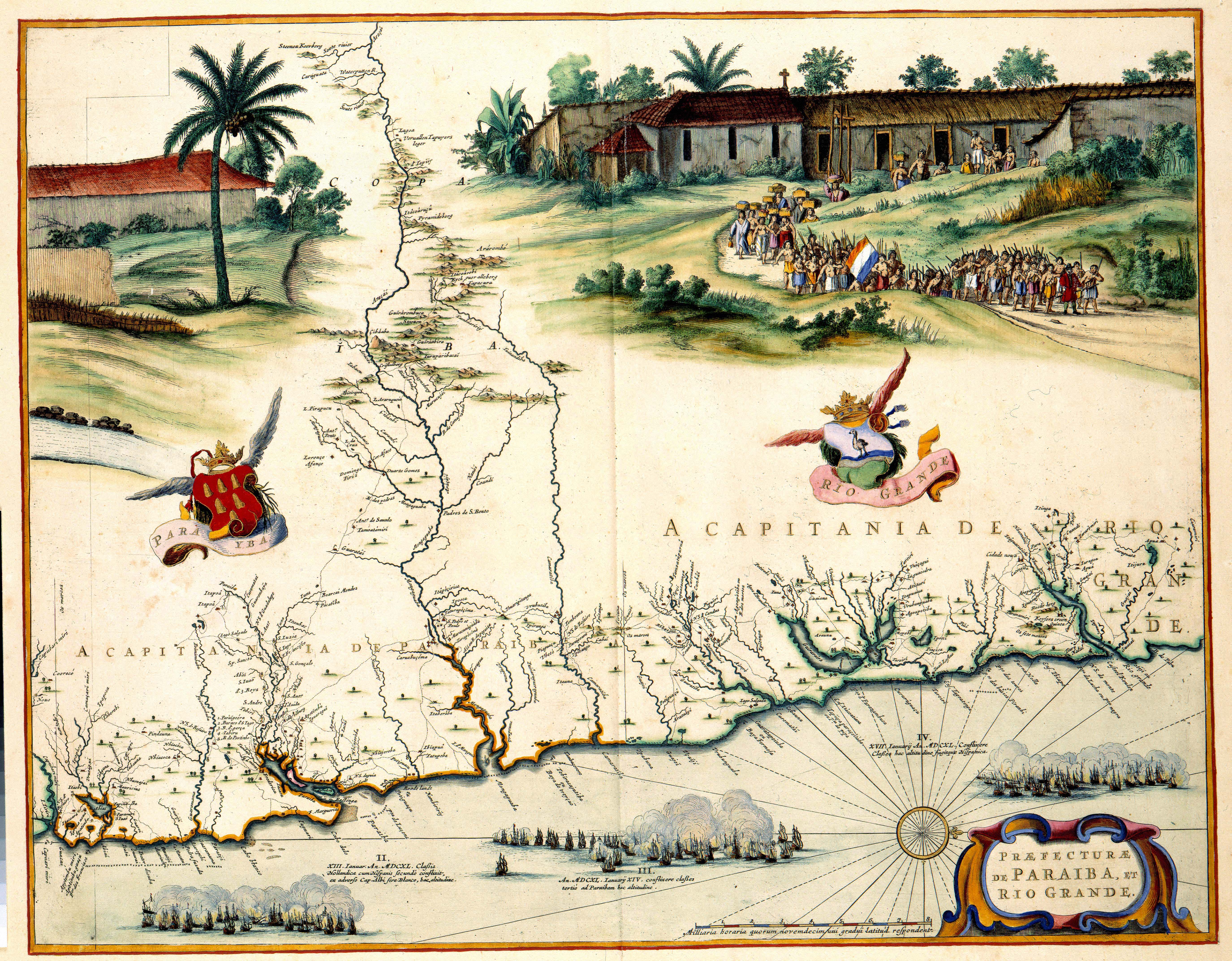
PRAEFECTURAE DE PARAIBA, ET RIO GRANDE |
||||||||||||||||||||||||||||||||||||||||||||||||||||||||||||||||||||
| Object type | map | ||||||||||||||||||||||||||||||||||||||||||||||||||||||||||||||||||||
| Description |
Nederlands: Tussen 1630 en 1654 werd een groot deel van Brazilië door de Nederlanders bezet. Gedurende deze periode werd het gebied in kaart gebracht door de kartografen Cornelis Goliath (overleden 1667/1668) en Georg Marcgraf. In 1643 verwerken zij de resultaten van deze opname in een fraaie wandkaart. Naar het voorbeeld van die kaart, publiceerde Joan Blaeu (1598-1673) in 1662 deze atlaskaart.; Links 1 wapenschild van Para Yba. Rechts 1 wapenschild van Rio Grande
English: Between 1630 and 1654 a large part of Brazil was occupied by the Dutch. In this period the area was surveyed and mapped by the cartographers Cornelis Goliath (deceased 1667/1668) and Georg Marcgraf. The results were compiled in a decorative wall map in 1643. Joan Blaeu (1598-1673) used the wall map as his source for this map in 1662. |
||||||||||||||||||||||||||||||||||||||||||||||||||||||||||||||||||||
| Language |
Dutch |
||||||||||||||||||||||||||||||||||||||||||||||||||||||||||||||||||||
| Date | 1662 | ||||||||||||||||||||||||||||||||||||||||||||||||||||||||||||||||||||
| Publication date |
circa |
||||||||||||||||||||||||||||||||||||||||||||||||||||||||||||||||||||
| Medium |
Nederlands: kopergravure
English: copper engraving print |
||||||||||||||||||||||||||||||||||||||||||||||||||||||||||||||||||||
| Dimensions | 42 x 54 cm | ||||||||||||||||||||||||||||||||||||||||||||||||||||||||||||||||||||
| Collection |
|
||||||||||||||||||||||||||||||||||||||||||||||||||||||||||||||||||||
| Accession number |
Description of the Atlas Van der Hagen in the catalogue of the KB: http://opc4.kb.nl/DB=1/TTL=1/LNG=EN/PPN?PPN=353012750 |
||||||||||||||||||||||||||||||||||||||||||||||||||||||||||||||||||||
| Place of creation | Amsterdam | ||||||||||||||||||||||||||||||||||||||||||||||||||||||||||||||||||||
| Notes | KW1049B13_097 - Volume 1 | ||||||||||||||||||||||||||||||||||||||||||||||||||||||||||||||||||||
| Related persons | Joan Blaeu - Cornelis Goliath - Georg Marcgraf | ||||||||||||||||||||||||||||||||||||||||||||||||||||||||||||||||||||
| Depicted locations | South-America - Brazil | ||||||||||||||||||||||||||||||||||||||||||||||||||||||||||||||||||||
| References | |||||||||||||||||||||||||||||||||||||||||||||||||||||||||||||||||||||
| Source/Photographer |
Source page at the Geheugen van Nederland / Memory of the Netherlands website.
|
||||||||||||||||||||||||||||||||||||||||||||||||||||||||||||||||||||
| Permission (Reusing this file) |
|
||||||||||||||||||||||||||||||||||||||||||||||||||||||||||||||||||||
.jpg)

| Object location | | View this and other nearby images on: OpenStreetMap |
|---|
File history
Click on a date/time to view the file as it appeared at that time.
| Date/Time | Thumbnail | Dimensions | User | Comment | |
|---|---|---|---|---|---|
| current | 14:54, 17 July 2015 | | 5,500 × 4,291 (3.46 MB) | OlafJanssen (talk | contribs) | GWToolset: Creating mediafile for OlafJanssen. |
You cannot overwrite this file.
File usage on Commons
The following 6 pages use this file:
File usage on other wikis
The following other wikis use this file:
- Usage on fr.wikipedia.org
- Usage on nl.wikipedia.org
- Usage on pt.wikisource.org