File:AbydosSatMap 1stDyn.jpg

Size of this preview: 755 × 600 pixels. Other resolutions: 302 × 240 pixels | 604 × 480 pixels | 992 × 788 pixels.
Original file (992 × 788 pixels, file size: 200 KB, MIME type: image/jpeg)
Captions
Captions
Add a one-line explanation of what this file represents
| Description |
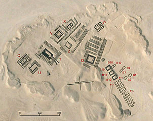
English: Map overlay of Peqer necropolis at Umm el-Qa'ab near Abydos in Egypt. The tombs of pharaohs are marked with letters.
|
| Date | (UTC) |
| Source | |
| Author |
|
| This is a retouched picture, which means that it has been digitally altered from its original version. Modifications: detail. The original can be viewed here: AbydosSatMap.jpg:
|
I, the copyright holder of this work, hereby publish it under the following license:
| This file is made available under the Creative Commons CC0 1.0 Universal Public Domain Dedication. | |
| The person who associated a work with this deed has dedicated the work to the public domain by waiving all of their rights to the work worldwide under copyright law, including all related and neighboring rights, to the extent allowed by law. You can copy, modify, distribute and perform the work, even for commercial purposes, all without asking permission.
|
Original upload log
edit
This image is a derivative work of the following images:
- File:AbydosSatMap.jpg licensed with Cc-zero
- 2010-06-28T01:28:05Z PLstrom 1421x824 (223739 Bytes) {{Information |Description={{en|1=Map overlay of Peqer necropolis at Umm el-Qa'ab near Abydos in Egypt. The tombs of pharaohs are marked with letters.}} |Source={{own}} |Author=[[User:PLstrom|PLstrom]] |Date= |Permission= |ot
Uploaded with derivativeFX
File history
Click on a date/time to view the file as it appeared at that time.
| Date/Time | Thumbnail | Dimensions | User | Comment | |
|---|---|---|---|---|---|
| current | 11:22, 27 August 2011 | | 992 × 788 (200 KB) | JMCC1 (talk | contribs) | {{Information |Description={{en|1=Map overlay of Peqer necropolis at Umm el-Qa'ab near Abydos in Egypt. The tombs of pharaohs are marked with letters.}} |Source=*File:AbydosSatMap.jpg |Date=2011-08-27 11:21 (UTC) |Author=*File:AbydosSatMap.jpg |
You cannot overwrite this file.
File usage on Commons
There are no pages that use this file.
File usage on other wikis
The following other wikis use this file:
- Usage on cs.wikipedia.org
- Usage on de.wikipedia.org
- Usage on es.wikipedia.org
- Usage on fr.wikipedia.org
- Usage on it.wikipedia.org
- Usage on pt.wikipedia.org
- Usage on ru.wikipedia.org