File:Aerial view of Brisbane City during the 1974 flood, January 1974.jpg

Size of this preview: 800 × 527 pixels. Other resolutions: 320 × 211 pixels | 640 × 421 pixels | 1,024 × 674 pixels | 1,280 × 843 pixels | 2,560 × 1,686 pixels | 12,000 × 7,903 pixels.
Original file (12,000 × 7,903 pixels, file size: 36.84 MB, MIME type: image/jpeg)
Captions
Captions
Add a one-line explanation of what this file represents
Summary edit
| Warning | The original file is very high-resolution. It might not load properly or could cause your browser to freeze when opened at full size. |
|---|
| Description |
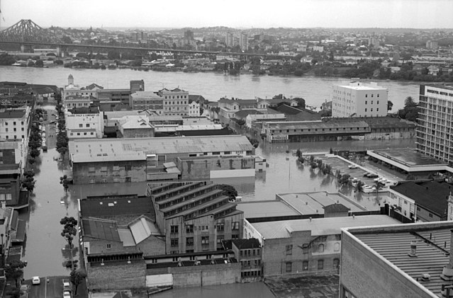
English: Aerial view of Brisbane City during the 1974 flood, January 1974, looking NE along Mary and Margaret Streets towards the Brisbane River with Kangaroo Point and the Story Bridge in the background. The Parkroyal Motor Inn is visible on the far right of the photo (now known as Royal on the Park). |
| Date | |
| Source | |
| Author | Queensland Premier's Department, State Public Relations Bureau, Photographic Unit |
| Permission (Reusing this file) |
This file is licensed under the Creative Commons Attribution 4.0 International license.
|
| Camera location | | View this and other nearby images on: OpenStreetMap |
|---|
File history
Click on a date/time to view the file as it appeared at that time.
| Date/Time | Thumbnail | Dimensions | User | Comment | |
|---|---|---|---|---|---|
| current | 16:22, 22 May 2018 | | 12,000 × 7,903 (36.84 MB) | Kerry Raymond (talk | contribs) | User created page with UploadWizard |
You cannot overwrite this file.
File usage on Commons
There are no pages that use this file.
File usage on other wikis
The following other wikis use this file:
- Usage on en.wikipedia.org