File:Aerial view of Matadi.jpg

Size of this preview: 800 × 517 pixels. Other resolutions: 320 × 207 pixels | 640 × 413 pixels | 1,020 × 659 pixels.
Original file (1,020 × 659 pixels, file size: 196 KB, MIME type: image/jpeg)
Captions
Captions
Add a one-line explanation of what this file represents
Summary
edit
| Description |
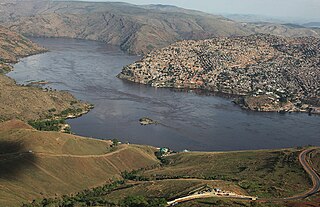
English: Aerial view of Matadi, the main port city in the DRC, located in the province of Bas-Congo, in the extreme west of the country. Français : Vue aérienne de Matadi, la principale ville portuaire de la RDC, située dans la province du Bas-Congo, à l’extrême ouest du pays. |
| Date | |
| Source | Photo-of-the-Day-17-November-2013 |
| Author | MONUSCO/Myriam Asmani |
Licensing
edit
This file is licensed under the Creative Commons Attribution-Share Alike 2.0 Generic license.
Attribution: MONUSCO/Myriam Asmani
- You are free:
- to share – to copy, distribute and transmit the work
- to remix – to adapt the work
- Under the following conditions:
- attribution – You must give appropriate credit, provide a link to the license, and indicate if changes were made. You may do so in any reasonable manner, but not in any way that suggests the licensor endorses you or your use.
- share alike – If you remix, transform, or build upon the material, you must distribute your contributions under the same or compatible license as the original.
| This image was originally posted to Flickr by MONUSCO at https://www.flickr.com/photos/67163702@N07/10873487253. It was reviewed on 30 April 2014 by FlickreviewR and was confirmed to be licensed under the terms of the cc-by-sa-2.0. |
| Annotations | This image is annotated: View the annotations at Commons |
File history
Click on a date/time to view the file as it appeared at that time.
| Date/Time | Thumbnail | Dimensions | User | Comment | |
|---|---|---|---|---|---|
| current | 08:28, 30 April 2014 | | 1,020 × 659 (196 KB) | Russavia (talk | contribs) | Transferred from Flickr via Flickr2commons |
You cannot overwrite this file.
File usage on Commons
The following 2 pages use this file:
- File:Photo-of-the-Day-17-November-2013 (10873487253).jpg (file redirect)
- File:Vue aérienne prés du port de la ville de Matadi.jpg (file redirect)
.jpg&redirect=no)
File usage on other wikis
The following other wikis use this file:
- Usage on azb.wikipedia.org
- Usage on de.wikipedia.org
- Usage on en.wikipedia.org
- Usage on es.wikipedia.org
- Usage on fa.wikipedia.org
- Usage on fi.wikipedia.org
- Usage on fr.wikipedia.org
- Usage on fr.wikivoyage.org
- Usage on hu.wikipedia.org
- Usage on io.wikipedia.org
- Usage on kk.wikipedia.org
- Usage on nds.wikipedia.org
- Usage on szl.wikipedia.org
- Usage on tl.wikipedia.org
- Usage on tr.wikipedia.org
- Usage on ur.wikipedia.org
- Usage on zu.wikipedia.org