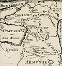
File:Alain Manesson Mallet. Georgie Armenie. 1683.jpg

Original file (2,158 × 3,491 pixels, file size: 3.44 MB, MIME type: image/jpeg)
Captions
Captions
Summary
edit| DescriptionAlain Manesson Mallet. Georgie Armenie. 1683.jpg |
English: Detailed map of the region between the Back Sea and Caspian Sea, extending south to Mesoptamia. Decorative cartouche. Map of Armenia and Georgia, Description de L'Universe (Alain Manesson Mallet, 1683).
Français : [Carte p.211 : carte de la] Géorgie, Arménie. [cote : Réserve DS 7 M 27 A]. [Illustrations de Description de l'Univers contenant les différents systèmes du Monde, les cartes générales et particulières de la géographie ancienne et moderne, les plans et profils des principales villes et des autres lieux plus considérables de la terre, avec les portraits des souverains qui y commandent, leurs blasons, titres et livrées, et les moeurs, religions, gouvernements et divers habillements de chaque nation...] / [Non identifié] ; Alain Manesson Mallet, aut. du texte |
|||||||||||||||||||||||
| Date | ||||||||||||||||||||||||
| Source |
|
|||||||||||||||||||||||
| Author |
creator QS:P170,Q362239 |
|||||||||||||||||||||||
| Other versions |
 |
|||||||||||||||||||||||
Licensing
edit|
This is a faithful photographic reproduction of a two-dimensional, public domain work of art. The work of art itself is in the public domain for the following reason:
The official position taken by the Wikimedia Foundation is that "faithful reproductions of two-dimensional public domain works of art are public domain".
This photographic reproduction is therefore also considered to be in the public domain in the United States. In other jurisdictions, re-use of this content may be restricted; see Reuse of PD-Art photographs for details. | |||||
| Annotations InfoField | This image is annotated: View the annotations at Commons |
File history
Click on a date/time to view the file as it appeared at that time.
| Date/Time | Thumbnail | Dimensions | User | Comment | |
|---|---|---|---|---|---|
| current | 20:50, 3 January 2022 |  | 2,158 × 3,491 (3.44 MB) | Racconish (talk | contribs) | |
| 21:11, 13 May 2011 |  | 1,200 × 1,814 (1.73 MB) | Geagea (talk | contribs) | == {{int:filedesc}} == {{Information |Description= {{en|1=Detailed map of the region between the Back Sea and Caspian Sea, extending south to Mesoptamia. Decorative cartouche. Map of Armenia and Georgia, Description de L'Universe (Alain Manesson Mallet, 1 |
You cannot overwrite this file.
File usage on Commons
The following 2 pages use this file:
Metadata
This file contains additional information such as Exif metadata which may have been added by the digital camera, scanner, or software program used to create or digitize it. If the file has been modified from its original state, some details such as the timestamp may not fully reflect those of the original file. The timestamp is only as accurate as the clock in the camera, and it may be completely wrong.
| Width | 2,564 px |
|---|---|
| Height | 3,776 px |
| Bits per component |
|
| Pixel composition | RGB |
| Orientation | Normal |
| Number of components | 3 |
| Horizontal resolution | 423 dpi |
| Vertical resolution | 423 dpi |
| Software used | Adobe Photoshop 23.1 (Windows) |
| File change date and time | 21:48, 3 January 2022 |
| Exif version | 2.31 |
| Color space | Uncalibrated |
| Unique ID of original document | 66B91A3D5754F6D55CE3414B471A9EFF |
| Date and time of digitizing | 22:38, 3 January 2022 |
| Date metadata was last modified | 22:48, 3 January 2022 |


