File:Armenia map numbered.svg

Size of this PNG preview of this SVG file: 587 × 599 pixels. Other resolutions: 235 × 240 pixels | 470 × 480 pixels | 752 × 768 pixels | 1,003 × 1,024 pixels | 2,006 × 2,048 pixels | 725 × 740 pixels.
Original file (SVG file, nominally 725 × 740 pixels, file size: 86 KB)
Captions
Captions
Add a one-line explanation of what this file represents
Summary edit
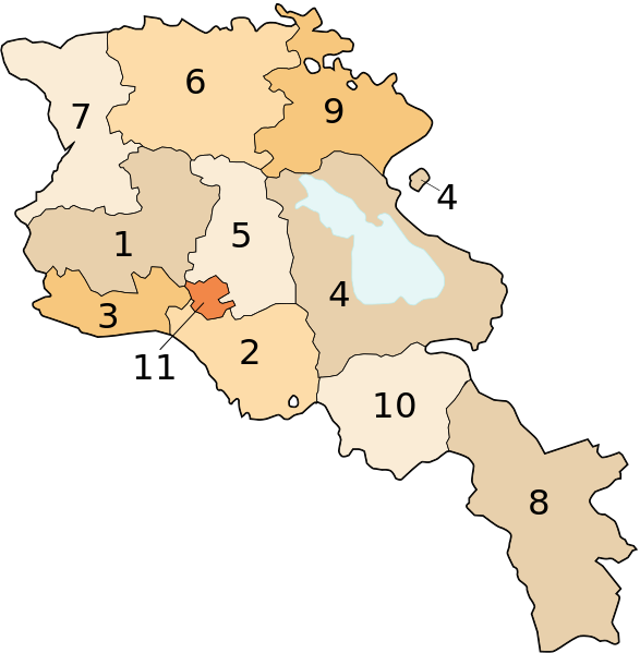
Image shows the eleven administrative subdivisions of Armenia:
- Aragatsotn (Արագածոտնի)
- Ararat (Արարատի)
- Armavir (Արմավիրի)
- Gegharkunik (Գեղարքունիքի)
- Kotayk (Կոտայքի)
- Lori (Լոռու)
- Shirak (Շիրակի)
- Syunik (Սյունիքի)
- Tavush (Տավուշի)
- Vayots Dzor (Վայոց Ձորի)
- Yerevan (Երևան) - special administrative status
Derived from a multiple of public sources and created using Inkscape.
Licensing edit

|
Permission is granted to copy, distribute and/or modify this document under the terms of the GNU Free Documentation License, Version 1.2 or any later version published by the Free Software Foundation; with no Invariant Sections, no Front-Cover Texts, and no Back-Cover Texts. A copy of the license is included in the section entitled GNU Free Documentation License. |
| This file is licensed under the Creative Commons Attribution-Share Alike 3.0 Unported license. | ||
| ||
| This licensing tag was added to this file as part of the GFDL licensing update. |
File history
Click on a date/time to view the file as it appeared at that time.
| Date/Time | Thumbnail | Dimensions | User | Comment | |
|---|---|---|---|---|---|
| current | 17:18, 13 October 2013 | | 725 × 740 (86 KB) | Fry1989 (talk | contribs) | Per AN, this type of POV is improper and unacceptable |
| 20:06, 11 October 2013 |  | 725 × 740 (80 KB) | Ankax Hayastan (talk | contribs) | Reverted to version as of 17:27, 26 September 2010 | |
| 20:00, 11 October 2013 |  | 725 × 740 (86 KB) | Fry1989 (talk | contribs) | Revert political POV | |
| 17:27, 26 September 2010 |  | 725 × 740 (80 KB) | Ankax Hayastan (talk | contribs) | Reverted to version as of 17:31, 25 November 2006 (((Exclaves deleted according to official map at http://www.gov.am/en/regions/))) | |
| 19:37, 25 November 2006 |  | 725 × 740 (86 KB) | Bastique (talk | contribs) | Cleanup | |
| 19:26, 25 November 2006 |  | 725 × 740 (84 KB) | Bastique (talk | contribs) | Enclaves | |
| 17:31, 25 November 2006 |  | 725 × 740 (80 KB) | Bastique (talk | contribs) | Fixed canvas size | |
| 17:27, 25 November 2006 |  | 744 × 1,052 (78 KB) | Bastique (talk | contribs) | Image shows the subdivisions of Armenia. Derived from a multiple of public sources and created using Inkscape. == Licensing == {{GFDL}} Image shows the eleven administrative subdivisions of Armenia: #Aragatsotn (Արագածոտնի) #[[Ararat (pr |
You cannot overwrite this file.
File usage on Commons
The following 12 pages use this file:
File usage on other wikis
The following other wikis use this file:
- Usage on ast.wikipedia.org
- Usage on avk.wikipedia.org
- Usage on awa.wikipedia.org
- Usage on az.wikipedia.org
- Usage on az.wiktionary.org
- Usage on be-tarask.wikipedia.org
- Usage on be.wikipedia.org
- Usage on bg.wikipedia.org
- Usage on bn.wikipedia.org
- Usage on bs.wikipedia.org
- Usage on ca.wikipedia.org
- Usage on cs.wikipedia.org
- Usage on cy.wikipedia.org
- Usage on el.wikipedia.org
- Usage on en.wikipedia.org
- Usage on eo.wikipedia.org
- Usage on es.wikipedia.org
- Usage on fa.wikipedia.org
- Usage on fr.wikipedia.org
- Usage on hi.wikipedia.org
View more global usage of this file.