File:Baginbun Head Map.png
Size of this preview: 800 × 509 pixels. Other resolutions: 320 × 204 pixels | 640 × 407 pixels | 825 × 525 pixels.
Original file (825 × 525 pixels, file size: 41 KB, MIME type: image/png)
Captions
Captions
Add a one-line explanation of what this file represents
Summary
edit
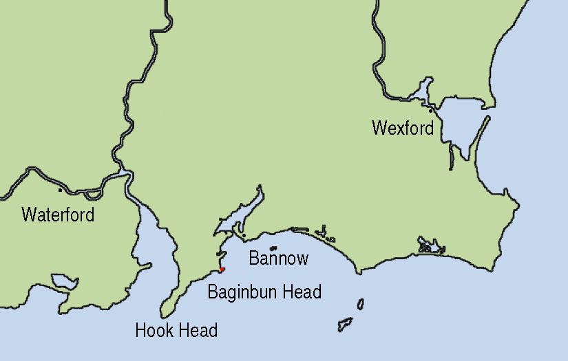
| Description | Map showing the location of Baginbun Head where Raymond le Gros landed in 1170 in Ireland. Waterford and Wexford were Norse settlements at that time. The first landing of the Normans took place at Bannow Island in 1169. (This island meanwhile joined the mainland.) |
| Date | |
| Source | This map is based on Image:Topography Ireland.jpg and my own work using Gimp and xfig. |
| Author | AFBorchert |
Licensing
edit
I, the copyright holder of this work, hereby publish it under the following licenses:

|
Permission is granted to copy, distribute and/or modify this document under the terms of the GNU Free Documentation License, Version 1.2 or any later version published by the Free Software Foundation; with no Invariant Sections, no Front-Cover Texts, and no Back-Cover Texts. A copy of the license is included in the section entitled GNU Free Documentation License. |
This file is licensed under the Creative Commons Attribution-Share Alike 4.0 International, 3.0 Unported, 2.5 Generic, 2.0 Generic and 1.0 Generic license.
- You are free:
- to share – to copy, distribute and transmit the work
- to remix – to adapt the work
- Under the following conditions:
- attribution – You must give appropriate credit, provide a link to the license, and indicate if changes were made. You may do so in any reasonable manner, but not in any way that suggests the licensor endorses you or your use.
- share alike – If you remix, transform, or build upon the material, you must distribute your contributions under the same or compatible license as the original.
You may select the license of your choice.
File history
Click on a date/time to view the file as it appeared at that time.
| Date/Time | Thumbnail | Dimensions | User | Comment | |
|---|---|---|---|---|---|
| current | 21:23, 3 December 2007 | | 825 × 525 (41 KB) | AFBorchert (talk | contribs) | {{Information |Description=Map showing the location of Baginbun Head where Raymond le Gros landed in 1170 in Ireland. Waterford and Wexford were Norse settlements at that time. The first landing of the Normans took place at Bann |
You cannot overwrite this file.
File usage on Commons
There are no pages that use this file.
File usage on other wikis
The following other wikis use this file:
- Usage on ca.wikipedia.org
- Usage on de.wikipedia.org
- Usage on en.wikipedia.org
- Usage on es.wikipedia.org
- Usage on fr.wikipedia.org
- Usage on ga.wikipedia.org
- Usage on id.wikipedia.org
- Usage on nl.wikipedia.org
- Usage on no.wikipedia.org
- Usage on tr.wikipedia.org
- Usage on www.wikidata.org