File:Baist Seattle 1905 plate 1 - B - raw.jpg

Size of this preview: 800 × 600 pixels. Other resolutions: 320 × 240 pixels | 640 × 480 pixels | 1,024 × 768 pixels | 1,280 × 960 pixels | 2,592 × 1,944 pixels.
Original file (2,592 × 1,944 pixels, file size: 640 KB, MIME type: image/jpeg)
Captions
Captions
Add a one-line explanation of what this file represents
| This is an image of a building or other location within the Pioneer Square-Skid Road Historic District, listed on the National Register of Historic Places. The district has been successively enlarged, and hence has multiple NRHP IDs: 70000086, 78000341, and 88000739 |
Summary
edit
| Description |
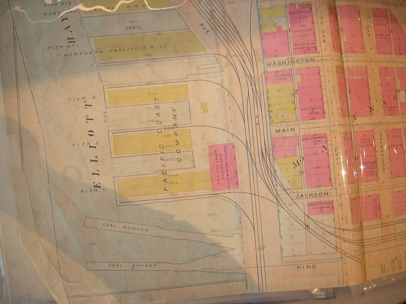
Part of plate 1, Baist's Real Estate Maps of Surveys of Seattle (1905). Shows building-by-building detail of the part of what is now the Pioneer Square neighborhood (then Seattle's commercial center) between S. King Street and Yesler Way, west of Occidental Way, and of the nearby waterfront on Elliott Bay. This is a raw image of a plastic-covered document: some reflections and also some shadow. |
| Date | |
| Source | Plate 1, Baist's Real Estate Maps of Surveys of Seattle, G. Wm. Baist, Philadelphia, 1905 |
| Author | G. Wm. Baist Co. |
| Permission (Reusing this file) |
PD-US |
Licensing
edit
This media file is in the public domain in the United States. This applies to U.S. works where the copyright has expired, often because its first publication occurred prior to January 1, 1929, and if not then due to lack of notice or renewal. See this page for further explanation.
|
 | |
 |
This image might not be in the public domain outside of the United States; this especially applies in the countries and areas that do not apply the rule of the shorter term for US works, such as Canada, Mainland China (not Hong Kong or Macao), Germany, Mexico, and Switzerland. The creator and year of publication are essential information and must be provided. See Wikipedia:Public domain and Wikipedia:Copyrights for more details.
|
File history
Click on a date/time to view the file as it appeared at that time.
| Date/Time | Thumbnail | Dimensions | User | Comment | |
|---|---|---|---|---|---|
| current | 00:14, 3 December 2007 | | 2,592 × 1,944 (640 KB) | Jmabel (talk | contribs) | == Summary == {{Information |Description=Part of plate 1, ''Baist's Real Estate Maps of Surveys of Seattle'' (1905). Shows building-by-building detail of the part of what is now the Pioneer Square neighborhood (then Seattle's commercial center) between S. |
You cannot overwrite this file.
File usage on Commons
There are no pages that use this file.
File usage on other wikis
The following other wikis use this file:
- Usage on en.wikipedia.org