File:Bangladesh-sat.jpg

Size of this preview: 463 × 599 pixels. Other resolutions: 185 × 240 pixels | 618 × 800 pixels.
Original file (618 × 800 pixels, file size: 117 KB, MIME type: image/jpeg)
Captions
Captions
Add a one-line explanation of what this file represents
Summary edit
| Description |
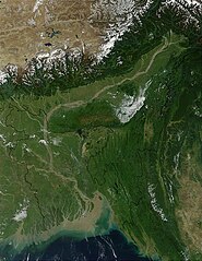
Français : Vue du Bangladesh, de la vallée du Brahmapoutre et des bouches du Gange par satellite |
| Date | |
| Source |
http://visibleearth.nasa.gov/view_rec.php?id=2250
|
| Author | Jacques Descloitres, MODIS Land Rapid Response Team, NASA/GSFC |
Licensing edit
| This file is in the public domain in the United States because it was solely created by NASA. NASA copyright policy states that "NASA material is not protected by copyright unless noted". (See Template:PD-USGov, NASA copyright policy page or JPL Image Use Policy.) | ||
 |
Warnings:
|
Original upload log edit
(All user names refer to fr.wikipedia)
- 2004-08-06 17:19 Nataraja 618×800×8 (119909 bytes)
File history
Click on a date/time to view the file as it appeared at that time.
| Date/Time | Thumbnail | Dimensions | User | Comment | |
|---|---|---|---|---|---|
| current | 15:39, 17 July 2007 | | 618 × 800 (117 KB) | Bayo (talk | contribs) | {{Information |Description=Vue du Bangladesh, de la vallée du Brahmapoutre et des bouches du Gange par satellite *Source : http://visibleearth.nasa.gov/cgi-bin/viewrecord?10722 *Status : Jacques Descloitres, MODIS Land Rapid Response Team, NASA/GSFC [[: |
You cannot overwrite this file.
File usage on Commons
There are no pages that use this file.
File usage on other wikis
The following other wikis use this file:
- Usage on bn.wikipedia.org
- Usage on de.wikiversity.org
- Usage on en.wikipedia.org
- Usage on es.wikipedia.org
- Usage on fr.wikipedia.org