File:Basin and Range Province Boundaries and Landmarks.svg

Size of this PNG preview of this SVG file: 383 × 464 pixels. Other resolutions: 198 × 240 pixels | 396 × 480 pixels | 634 × 768 pixels | 845 × 1,024 pixels | 1,690 × 2,048 pixels.
Original file (SVG file, nominally 383 × 464 pixels, file size: 324 KB)
Captions
Captions
Map of the Basin and Range Province
O5/19/2023
Summary
edit
| Description |
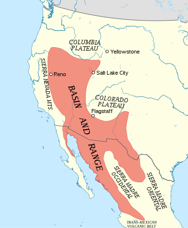
English: Map of the Basin and Range Province, including relevant landmarks. |
| Date | |
| Source | vectorization of w:File:Basin and Range Province Boundaries and Landmarks.jpg |
| Author |
|
Licensing
edit
This file is licensed under the Creative Commons Attribution 3.0 Unported license.
- You are free:
- to share – to copy, distribute and transmit the work
- to remix – to adapt the work
- Under the following conditions:
- attribution – You must give appropriate credit, provide a link to the license, and indicate if changes were made. You may do so in any reasonable manner, but not in any way that suggests the licensor endorses you or your use.
File history
Click on a date/time to view the file as it appeared at that time.
| Date/Time | Thumbnail | Dimensions | User | Comment | |
|---|---|---|---|---|---|
| current | 23:59, 1 October 2018 | | 383 × 464 (324 KB) | AntiCompositeNumber (talk | contribs) | {{Information |description ={{en|1=Map of the Basin and Range Province, including relevant landmarks.}} |date =2018-10-01 |source ={{vectorization}} of w:File:Basin and Range Province Boundaries and Landmarks.jpg |author =* {{Original image}}: Kathleen Smith * {{Vectorization}}: AntiCompositeNumber }} {{Graphic Lab |1=en |2=map }} Category:Maps of Basin and Range Province |
You cannot overwrite this file.
File usage on Commons
The following 2 pages use this file:
File usage on other wikis
The following other wikis use this file:
- Usage on ar.wikipedia.org
- Usage on ast.wikipedia.org
- Usage on de.wikipedia.org
- Usage on en.wikipedia.org
- Usage on ja.wikipedia.org
- Usage on ru.wikipedia.org
- Usage on tr.wikipedia.org
- Usage on www.wikidata.org