File:Bayern Regionenplanung Region7.svg

Size of this PNG preview of this SVG file: 602 × 600 pixels. Other resolutions: 241 × 240 pixels | 482 × 480 pixels | 771 × 768 pixels | 1,028 × 1,024 pixels | 2,056 × 2,048 pixels | 4,944 × 4,924 pixels.
Original file (SVG file, nominally 4,944 × 4,924 pixels, file size: 727 KB)
Captions
Captions
Add a one-line explanation of what this file represents
Summary
edit
| Description |
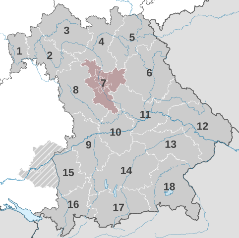
Deutsch: Das bayerische Staatsgebiet wird in 18 Regionen gegliedert, innerhalb derer intensive Lebens- und Wirtschaftsbeziehungen bestehen oder entwickelt werden sollen.
|
||||||||||||||||||
| Date | |||||||||||||||||||
| Source |
Own work Datenquelle: Rauminformationssystem RISBY, RegionsgrenzenThis vector image includes elements that have been taken or adapted from this file: This vector image includes elements that have been taken or adapted from this file: W3C-validity not checked. |
||||||||||||||||||
| Author |
Stefan Meister based on work of TUBS |
Licensing
edit
Stefan Meister, the copyright holder of this work, hereby publishes it under the following license:
This file is licensed under the Creative Commons Attribution-Share Alike 3.0 Unported, 2.5 Generic, 2.0 Generic and 1.0 Generic license.
Attribution: Stefan Meister
- You are free:
- to share – to copy, distribute and transmit the work
- to remix – to adapt the work
- Under the following conditions:
- attribution – You must give appropriate credit, provide a link to the license, and indicate if changes were made. You may do so in any reasonable manner, but not in any way that suggests the licensor endorses you or your use.
- share alike – If you remix, transform, or build upon the material, you must distribute your contributions under the same or compatible license as the original.
File history
Click on a date/time to view the file as it appeared at that time.
| Date/Time | Thumbnail | Dimensions | User | Comment | |
|---|---|---|---|---|---|
| current | 21:51, 1 December 2016 | | 4,944 × 4,924 (727 KB) | StefanMeister (talk | contribs) | =={{int:filedesc}}== {{Information |description = {{DeLocMaps |lk=Planungsregionen in Bayern |land=Bayern }} {{de|1=Das bayerische Staatsgebiet wird in 18 Regionen gegliedert, innerhalb derer intensive Lebens- und Wirtschaftsbeziehungen... |
You cannot overwrite this file.
File usage on Commons
The following page uses this file: