File:Beltway sniper map.png
No higher resolution available.
Beltway_sniper_map.png (463 × 558 pixels, file size: 26 KB, MIME type: image/png)
Captions
Captions
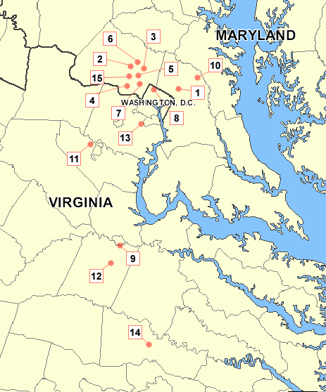
Map of the locations of the Beltway sniper attacks
Summary edit
| Description | Map of the locations of the Beltway sniper attacks |
| Date | |
| Source | Made using an existing map of the area from http://www.nationalatlas.gov. Numbering references [1]. |
| Author | User:Tom |

|
This map image could be re-created using vector graphics as an SVG file. This has several advantages; see Commons:Media for cleanup for more information. If an SVG form of this image is available, please upload it and afterwards replace this template with
{{vector version available|new image name}}.
It is recommended to name the SVG file “Beltway sniper map.svg”—then the template Vector version available (or Vva) does not need the new image name parameter. |
Licensing edit
I, the copyright holder of this work, hereby publish it under the following licenses:

|
Permission is granted to copy, distribute and/or modify this document under the terms of the GNU Free Documentation License, Version 1.2 or any later version published by the Free Software Foundation; with no Invariant Sections, no Front-Cover Texts, and no Back-Cover Texts. A copy of the license is included in the section entitled GNU Free Documentation License. |
| This file is licensed under the Creative Commons Attribution-Share Alike 3.0 Unported license. | ||
| ||
| This licensing tag was added to this file as part of the GFDL licensing update. |
You may select the license of your choice.
File history
Click on a date/time to view the file as it appeared at that time.
| Date/Time | Thumbnail | Dimensions | User | Comment | |
|---|---|---|---|---|---|
| current | 13:26, 28 June 2008 | | 463 × 558 (26 KB) | Tom (talk | contribs) | {{Information |Description=Map of the locations of the {{w|Beltway sniper attacks}} |Source=made using an existing map of the area from http://www.nationalatlas.gov. Numbering references [http://www.cnn.com/interactive/us/0210/map.sniper.trail.special/fr |
You cannot overwrite this file.
File usage on Commons
The following page uses this file:
File usage on other wikis
The following other wikis use this file:
- Usage on de.wikipedia.org
- Usage on en.wikipedia.org
- Usage on hy.wikipedia.org
- Usage on ko.wikipedia.org
- Usage on nl.wikipedia.org
- Usage on ru.wikipedia.org
- Usage on simple.wikipedia.org
- Usage on ta.wikipedia.org
- Usage on ta.wikinews.org
- Usage on zh.wikipedia.org