File:Bevoelkerungsdichte - Oesterreich.svg

Size of this PNG preview of this SVG file: 800 × 566 pixels. Other resolutions: 320 × 226 pixels | 640 × 453 pixels | 1,024 × 724 pixels | 1,280 × 905 pixels | 2,560 × 1,810 pixels | 1,052 × 744 pixels.
Original file (SVG file, nominally 1,052 × 744 pixels, file size: 311 KB)
Captions
Captions
Add a one-line explanation of what this file represents
| Description |
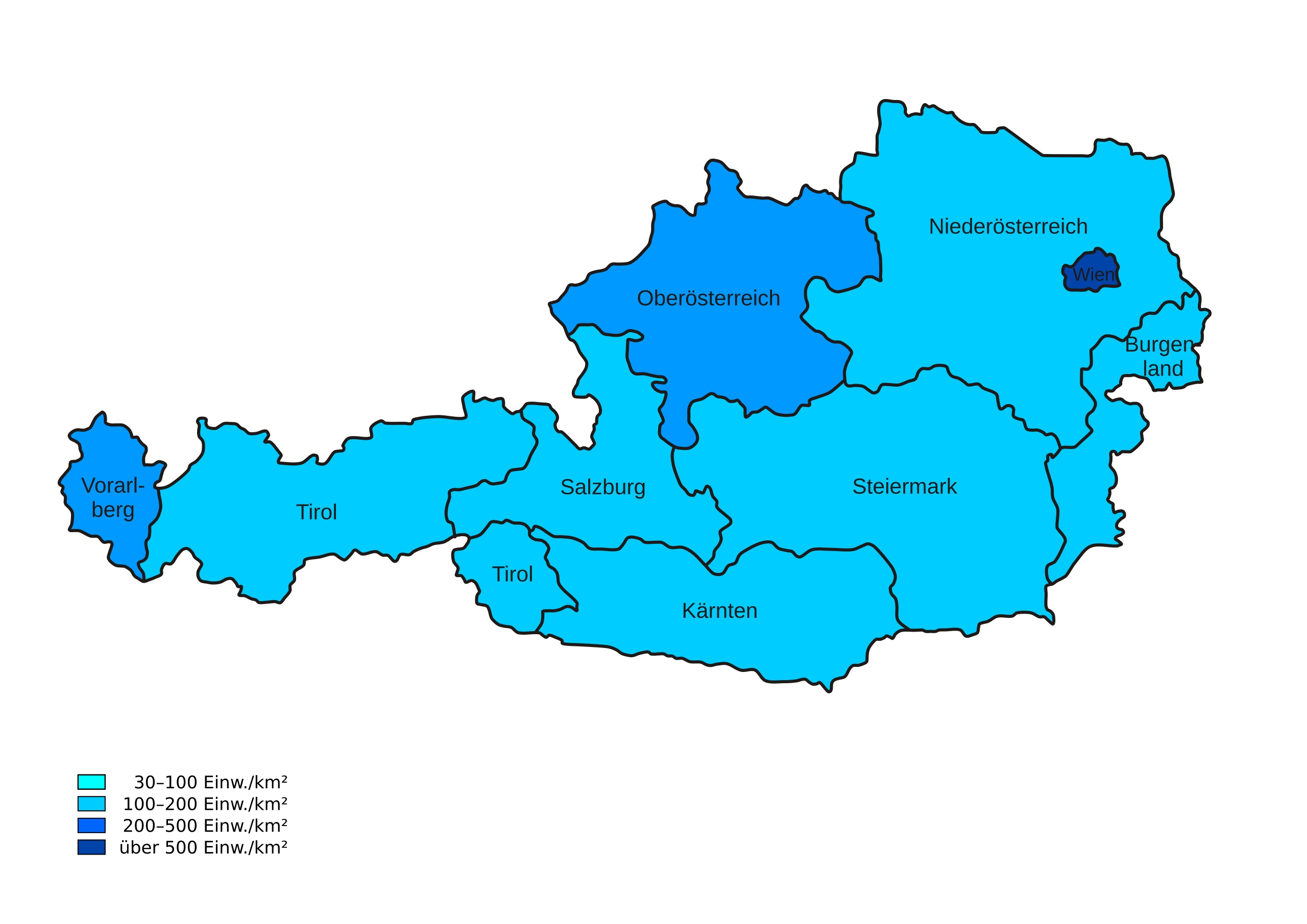
Österreichische Bundesländer als SVG - Saubere Vektor-Vorlage zur Weiterverwendung in anderen Karten - Landesgrenze, Bundesländergrenzen, Bundesländerflächen und -namen sind getrennt selektierbar. |
| Date | (UTC) |
| Source | |
| Author |
|
| This is a retouched picture, which means that it has been digitally altered from its original version. Modifications: Bevölkerungsdichten. The original can be viewed here: Karte Österreich Bundesländer.svg:
|
This file is licensed under the Creative Commons Attribution-Share Alike 3.0 Unported license.
- You are free:
- to share – to copy, distribute and transmit the work
- to remix – to adapt the work
- Under the following conditions:
- attribution – You must give appropriate credit, provide a link to the license, and indicate if changes were made. You may do so in any reasonable manner, but not in any way that suggests the licensor endorses you or your use.
- share alike – If you remix, transform, or build upon the material, you must distribute your contributions under the same or compatible license as the original.
Original upload log
edit
This image is a derivative work of the following images:
- Image:Karte_Österreich_Bundesländer.svg licensed with Cc-by-sa-2.5
- 2007-05-30T18:53:04Z Lencer 1052x744 (287724 Bytes) {{Information |Description= Österreichische Bundesländer als SVG |Source="own work" |Date=Mai 2007 |Author=[[User:Lencer|Lencer]] |other_versions= }} == Licensing == {{self|cc-by-sa-2.5}}
Uploaded with derivativeFX

|
This SVG file contains embedded text that can be translated into your language, using any capable SVG editor, text editor or the SVG Translate tool. For more information see: About translating SVG files. |
File history
Click on a date/time to view the file as it appeared at that time.
| Date/Time | Thumbnail | Dimensions | User | Comment | |
|---|---|---|---|---|---|
| current | 14:00, 20 February 2011 | | 1,052 × 744 (311 KB) | Erik del Toro Streb (talk | contribs) | typographisch korrigiert |
| 13:08, 23 June 2008 |  | 1,052 × 744 (311 KB) | Rabenkind (talk | contribs) | {{Information |Description= |Source= |Date= |Author= |Permission= |other_versions= }} | |
| 13:07, 23 June 2008 |  | 1,052 × 744 (311 KB) | Rabenkind (talk | contribs) | Inkscape-Format Category:SVG maps of Austria Category:Population maps | |
| 13:04, 23 June 2008 |  | 1,052 × 744 (305 KB) | Rabenkind (talk | contribs) | {{Information |Description=Österreichische Bundesländer als SVG<br>- Saubere Vektor-Vorlage zur Weiterverwendung in anderen Karten<br>- Landesgrenze, Bundesländergrenzen, Bundesländerflächen und -namen sind getrennt selektierbar. |Source=*[[:Image:Ka |
You cannot overwrite this file.
File usage on Commons
The following 2 pages use this file:
File usage on other wikis
The following other wikis use this file:
- Usage on af.wikipedia.org
- Usage on de.wikipedia.org
- Usage on pt.wikipedia.org
- Usage on sv.wikipedia.org