File:Bezymianny oli 2023097 lrg.jpg

Size of this preview: 738 × 599 pixels. Other resolutions: 296 × 240 pixels | 591 × 480 pixels | 946 × 768 pixels | 1,261 × 1,024 pixels | 2,522 × 2,048 pixels | 9,373 × 7,613 pixels.
Original file (9,373 × 7,613 pixels, file size: 4.99 MB, MIME type: image/jpeg)
Captions
Captions
Add a one-line explanation of what this file represents
Summary
edit
| Description |
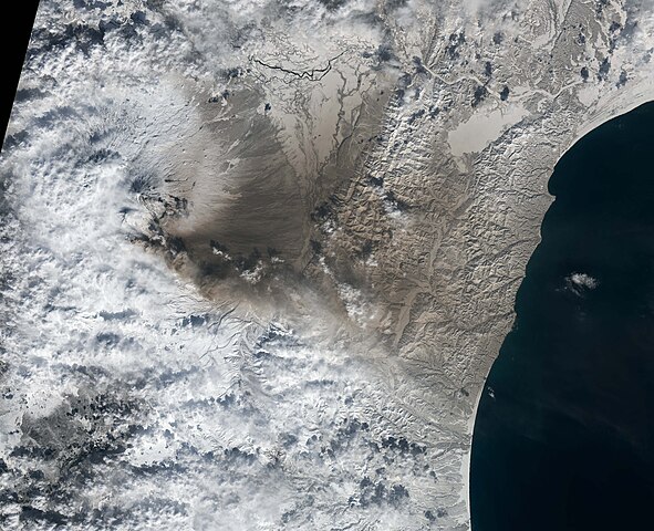
English: Bezymianny volcano erupting on 7 April 2023. The volcano, about 100 kilometers (60 miles) southwest of Shiveluch, has been puffing with small-scale explosions for weeks, but strong explosions sent volcanic materials soaring up to 10-12 kilometers early in the day on April 7, also prompting KVERT to raise its aviation warning to code red. As this high-altitude ash streamed east, the intensity of the eruption slowed over the course of the day. By the end of the day, KVERT declared the period of strong eruptions over.
The Operational Land Imager (OLI) on Landsat 8 acquired imagery of the eruption at 10:15 a.m. local time (00:15 UTC) on April 7. The image shows ash blanketing a snowy landscape to the east of Bezymianny. After a period of quiet that geologists think had spanned roughly 1000 years, Bezymianny erupted violently in 1957. It has been frequently active ever since, according to data published by the Smithsonian Institution’s Global Volcanism Program. |
| Date | |
| Source | https://earthobservatory.nasa.gov/images/151197/kamchatka-erupts |
| Author | NASA Earth Observatory images by Lauren Dauphin, using MODIS data from NASA EOSDIS LANCE and GIBS/Worldview and Landsat data from the U.S. Geological Survey. |
Licensing
edit
| This file is in the public domain in the United States because it was solely created by NASA. NASA copyright policy states that "NASA material is not protected by copyright unless noted". (See Template:PD-USGov, NASA copyright policy page or JPL Image Use Policy.) | ||
 |
Warnings:
|
File history
Click on a date/time to view the file as it appeared at that time.
| Date/Time | Thumbnail | Dimensions | User | Comment | |
|---|---|---|---|---|---|
| current | 18:19, 16 April 2023 | | 9,373 × 7,613 (4.99 MB) | C messier (talk | contribs) | Uploaded a work by NASA Earth Observatory images by Lauren Dauphin, using MODIS data from NASA EOSDIS LANCE and GIBS/Worldview and Landsat data from the U.S. Geological Survey. from https://earthobservatory.nasa.gov/images/151197/kamchatka-erupts with UploadWizard |
You cannot overwrite this file.
File usage on Commons
There are no pages that use this file.
File usage on other wikis
The following other wikis use this file:
- Usage on cs.wikipedia.org