File:Black Prince's campaign 1356.svg

Size of this PNG preview of this SVG file: 665 × 599 pixels. Other resolutions: 266 × 240 pixels | 533 × 480 pixels | 853 × 768 pixels | 1,137 × 1,024 pixels | 2,273 × 2,048 pixels | 1,181 × 1,064 pixels.
Original file (SVG file, nominally 1,181 × 1,064 pixels, file size: 420 KB)
Captions
Captions
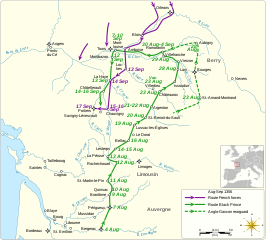
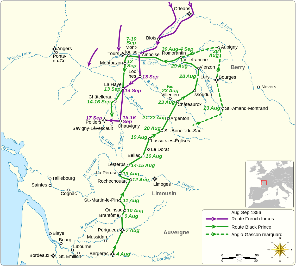
The routes of the Anglo-Gascon and French armies
Summary edit
| Description |
English: Map showing the routes of the Anglo-Gascon and French armies during the Black Prince's chevauchée of 1356.
|
|||||||||||||||||||||||||||||||||||||||||||||||||||
| Date | ||||||||||||||||||||||||||||||||||||||||||||||||||||
| Source |
Own work based on: References:
|
|||||||||||||||||||||||||||||||||||||||||||||||||||
| Author | Goran_tek-en | |||||||||||||||||||||||||||||||||||||||||||||||||||
| Permission (Reusing this file) |
This file is licensed under the Creative Commons Attribution-Share Alike 4.0 International license. Attribution: Goran_tek-en
|
|||||||||||||||||||||||||||||||||||||||||||||||||||
| SVG development | This vector image was created with Inkscape. |
|||||||||||||||||||||||||||||||||||||||||||||||||||

.jpg)

| Object location | | View this and other nearby images on: OpenStreetMap |
|---|
File history
Click on a date/time to view the file as it appeared at that time.
| Date/Time | Thumbnail | Dimensions | User | Comment | |
|---|---|---|---|---|---|
| current | 17:28, 7 February 2022 | | 1,181 × 1,064 (420 KB) | Goran tek-en (talk | contribs) | one word removed as requested by Gog the Mild |
| 16:42, 6 February 2022 |  | 1,181 × 1,064 (422 KB) | Goran tek-en (talk | contribs) | {{Information |description ={{en|Map showing the routes of the Anglo-Gascon and French armies during the Black Prince's campaign of 1356.}} {{Institution |wikidata=Q12551}} {{Institution |wikidata=Q201692}} {{Institution |wikidata=Q142}} {{Institution |wikidata=Q6130}} |date =2022-02-06 |source ={{Own based|Maps template-en.svg|BlankMap-World gray.svg|b1=Sting|b2=LivingShadow}} <br> Derived from; *[https://www.openstreetmap.org/#map=8/44.678/-0.324 OSM] Information... |
You cannot overwrite this file.
File usage on Commons
The following 3 pages use this file:
File usage on other wikis
The following other wikis use this file:
- Usage on en.wikipedia.org