File:Blaufelden in SHA.png

Size of this preview: 608 × 600 pixels. Other resolutions: 243 × 240 pixels | 486 × 480 pixels | 750 × 740 pixels.
Original file (750 × 740 pixels, file size: 24 KB, MIME type: image/png)
Captions
Captions
Add a one-line explanation of what this file represents
Summary
edit
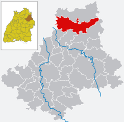
- Deutsch: Karte von Blaufelden im Landkreis Schwäbisch Hall, Baden-Württemberg, Deutschland.
Author
edit
- English: The map was created by Benutzer:Schiwago and modified by Rosenzweig.
- Deutsch: Die Karte wurde erstellt von Schiwago und modifiziert von Rosenzweig.
Licensing
edit
| This work has been released into the public domain by its author, Schiwago at German Wikipedia. This applies worldwide. In some countries this may not be legally possible; if so: Schiwago grants anyone the right to use this work for any purpose, without any conditions, unless such conditions are required by law. |
File history
Click on a date/time to view the file as it appeared at that time.
| Date/Time | Thumbnail | Dimensions | User | Comment | |
|---|---|---|---|---|---|
| current | 18:18, 6 November 2006 | | 750 × 740 (24 KB) | Rosenzweig (talk | contribs) | == Description == * {{en|Map of Blaufeldem in the Landkreis (district) Schwäbisch Hall, Baden-Württemberg, Germany.}} * {{de|Karte von Blaufelden im Landkreis Schwäbisch Hall, Baden-Württemberg, Deutschland.}} |
You cannot overwrite this file.
File usage on Commons
There are no pages that use this file.
File usage on other wikis
The following other wikis use this file:
- Usage on pms.wikipedia.org
- Usage on pt.wikipedia.org
- Usage on ro.wikipedia.org
- Usage on vi.wikipedia.org