File:Boris Stones Map Taranovich.jpg

Size of this preview: 740 × 600 pixels. Other resolutions: 296 × 240 pixels | 593 × 480 pixels | 822 × 666 pixels.
Original file (822 × 666 pixels, file size: 140 KB, MIME type: image/jpeg)
Captions
Captions
Add a one-line explanation of what this file represents
Summary
edit
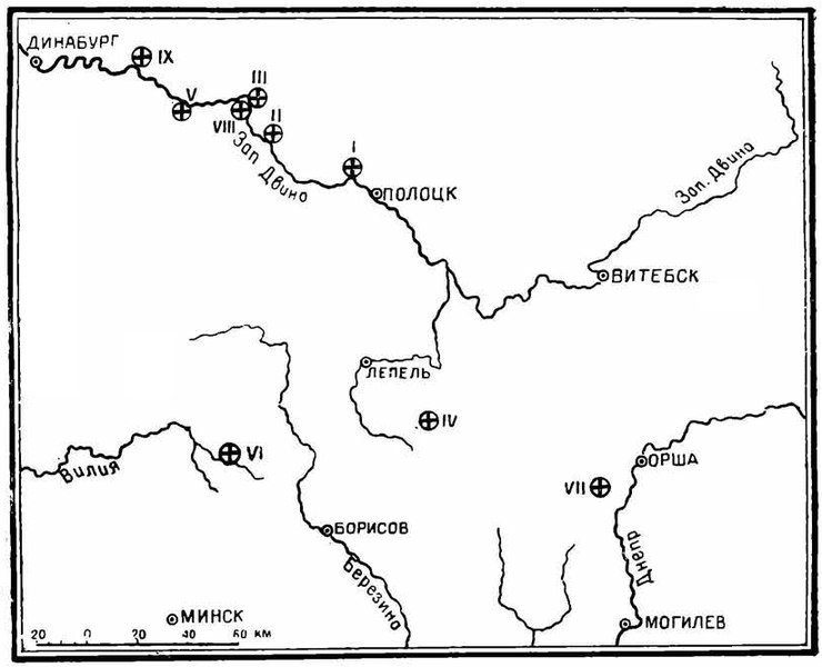
| Description | Рис. 1. Карта древних камней с надписями. I - Борисов камень у Полоцка; II - Борисов камень у д. Наковники; III - Борисов камень у д. Болотки; IV - Борисов камень у с. В. Городец; V - Борисов камень у г. Друя; VI - Борисов камень у д. Каменки; VII - Рогволодов камень; VIII - «Сулиборь хрьсть»; IX - камень «Святополк-Александр», уничтоженный в 1818 г. |
| Date | |
| Source | Таранович В. П. К вопросу о древних лапидарных памятниках с ист. надписями на территории Белорусской ССР. // Советская Археология / ак. Б. Д. Греков. — Москва - Ленинград: Издательство Академии Наук СССР, 1946. — Т. VIII. — С. 249-260. — 320 с. — 3000 экз. |
| Author | В. П. Таранович (16.09.1874 — ??.09.1941) |
Licensing
edit
|
This work is in the public domain in its country of origin and other countries and areas where the copyright term is the author's life plus 70 years or fewer. | |
| This file has been identified as being free of known restrictions under copyright law, including all related and neighboring rights. | |
File history
Click on a date/time to view the file as it appeared at that time.
| Date/Time | Thumbnail | Dimensions | User | Comment | |
|---|---|---|---|---|---|
| current | 11:19, 3 January 2018 | | 822 × 666 (140 KB) | Gandvik (talk | contribs) | clear |
| 12:09, 5 January 2017 |  | 822 × 666 (142 KB) | Gandvik (talk | contribs) | {{Information | Description = Карта древних камней с надписями. | Author = В. П. Таранович | Date = 1941 | Source = Таран... |
You cannot overwrite this file.
File usage on Commons
There are no pages that use this file.
File usage on other wikis
The following other wikis use this file:
- Usage on bg.wikipedia.org
- Usage on ru.wikipedia.org
- Usage on ru.wikisource.org