File:Brigittenau (Wien) - Engerthhof.JPG

Size of this preview: 800 × 533 pixels. Other resolutions: 320 × 213 pixels | 640 × 427 pixels | 1,024 × 683 pixels | 1,280 × 854 pixels | 2,560 × 1,707 pixels | 4,190 × 2,794 pixels.
Original file (4,190 × 2,794 pixels, file size: 9.05 MB, MIME type: image/jpeg)
Captions
Captions
Add a one-line explanation of what this file represents
Summary edit
_-_Engerthhof.JPG&action=edit§ion=1)
| Description |
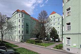
Deutsch: Der „Engerthhof“ in der Engerthstraße im 20. Wiener Gemeindebezirk Brigittenau. Nachdem bereits um 1905 nach Plänen des Architekten Leopold Simony die Arbeiterwohnhäuser Engerthstraße 41–45 (?) errichtet wurden ([1]), wurde als erstes Projekt der 1907 gegründeten Erste gemeinnützige Baugesellschaft für Arbeiterwohnhäuser, Gruppe Brigittenau (Erste gemeinnützige Wohnungsgesellschaft) ([2]) der Engerthhof (Engerthstraße 43–55) mit rd. 180 Wohneinheiten (andere Angabe: 360 Mietwohnungen: [3]) errichtet und 1911 fertiggestellt ([4]). In den Jahren von 2004 bis 2009 wurde die Anlage um rd. 16,5 Mio. saniert. Dabei wurde unter anderem eine Wärmedämmung angebracht, die Dachgeschosse ausgebaut und Lifte eingebaut ([5]). Benannt ist die Wohnhausanlage zu Ehren des deutsch-österreichischen Architekten, Maschinenbauingenieurs und Hochschullehrers Wilhelm von Engerth (1814–1884). |
| Date | |
| Source | Own work |
| Author | C.Stadler/Bwag |
| Permission (Reusing this file) |
Deutsch: Hallo, du darfst mein Foto kostenlos nutzen, aber nenne mich bitte als Fotograf, beispielsweise „Foto: C.Stadler/Bwag“ oder © C.Stadler/Bwag; CC-BY-SA-4.0. Auf mehr Angaben bestehe ich nicht - im Gegensatz zu manch anderen, die die Vorgaben der unten angeführten Lizenzierung auf Punkt und Beistrich einfordern. English: Feel free to use my photos, but please mention me as the author like © C.Stadler/Bwag or © C.Stadler/Bwag; CC-BY-SA-4.0 (that's good enough) and if you want send me a message: bwag@gmx.net. |
| Object location | | View this and other nearby images on: OpenStreetMap |
|---|
_-_Engerthhof.JPG¶ms=048.243060_N_0016.382510_E_globe:Earth_class:object_type:object__&language=en)
| Camera location | | View this and other nearby images on: OpenStreetMap |
|---|
_-_Engerthhof.JPG¶ms=048.242690_N_0016.382100_E_globe:Earth_type:camera_heading:15.00&language=en)
Licensing edit
_-_Engerthhof.JPG&action=edit§ion=2)
I, the copyright holder of this work, hereby publish it under the following license:
This file is licensed under the Creative Commons Attribution-Share Alike 4.0 International license.
- You are free:
- to share – to copy, distribute and transmit the work
- to remix – to adapt the work
- Under the following conditions:
- attribution – You must give appropriate credit, provide a link to the license, and indicate if changes were made. You may do so in any reasonable manner, but not in any way that suggests the licensor endorses you or your use.
- share alike – If you remix, transform, or build upon the material, you must distribute your contributions under the same or compatible license as the original.
File history
Click on a date/time to view the file as it appeared at that time.
| Date/Time | Thumbnail | Dimensions | User | Comment | |
|---|---|---|---|---|---|
| current | 08:29, 26 April 2021 | | 4,190 × 2,794 (9.05 MB) | Bwag (talk | contribs) | s |
| 21:46, 25 April 2021 |  | 4,400 × 2,780 (9.9 MB) | Bwag (talk | contribs) | {{Information |Description= {{de|1= Der „Engerthhof“ in der Engerthstraße im 20. Wiener Gemeindebezirk Brigittenau.<br/>Nachdem bereits um 1905 nach Plänen des Architekten Leopold Simony die Arbeiterwohnhäuser Engerthstraße 41–45 (?) errichtet wurden ([https://www.geschichtewiki.wien.gv.at/Engerthstra%C3%9Fe], wurde als erstes Projekt der 1907 gegründeten ''Erste gemeinnützige Baugesellschaft für Arbeiterwohnhäuser, Gruppe Brigittenau'' (Erste gemeinnützige Wohnungsgesellschaft) der Engerthh... |
You cannot overwrite this file.
File usage on Commons
The following page uses this file:
File usage on other wikis
The following other wikis use this file:
- Usage on de.wikipedia.org
- Usage on www.wikidata.org
_-_Engerthhof.JPG&oldid=833834461)