File:Burgruine Hernstein.jpg
Size of this preview: 800 × 523 pixels. Other resolutions: 320 × 209 pixels | 640 × 419 pixels | 1,024 × 670 pixels | 1,280 × 838 pixels | 2,656 × 1,738 pixels.
Original file (2,656 × 1,738 pixels, file size: 2.77 MB, MIME type: image/jpeg)
File information
Structured data
Captions
Summary
editDescriptionBurgruine Hernstein.jpg |
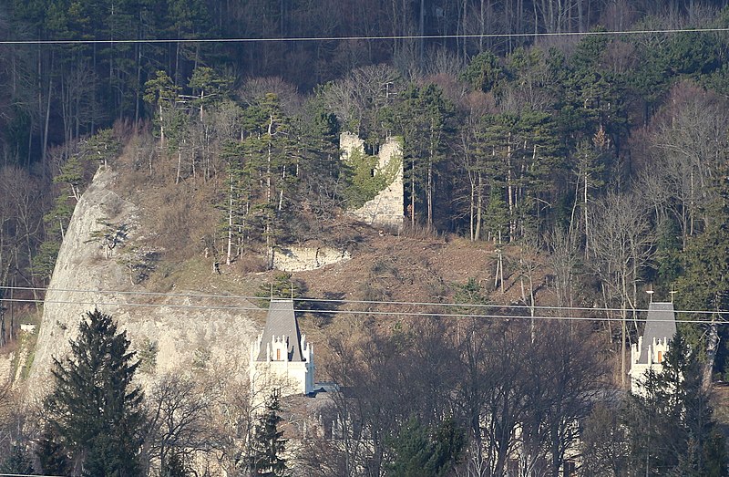
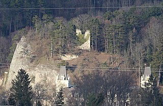
Deutsch: Ruine Hernstein oberhalb des Schlosses in Hernstein, Niederösterreich. |
|||
Date | ||||
Source | Own work | |||
Author | Braveheart | |||
Other versions |
|
Camera location | 47° 53′ 21.71″ N, 16° 05′ 51.94″ E | View this and other nearby images on: OpenStreetMap | 47.889365; 16.097762 |
---|
Licensing
editI, the copyright holder of this work, hereby publish it under the following license:
This file is licensed under the Creative Commons Attribution-Share Alike 4.0 International license.
- You are free:
- to share – to copy, distribute and transmit the work
- to remix – to adapt the work
- Under the following conditions:
- attribution – You must give appropriate credit, provide a link to the license, and indicate if changes were made. You may do so in any reasonable manner, but not in any way that suggests the licensor endorses you or your use.
- share alike – If you remix, transform, or build upon the material, you must distribute your contributions under the same or compatible license as the original.
File history
Click on a date/time to view the file as it appeared at that time.
Date/Time | Thumbnail | Dimensions | User | Comment | |
---|---|---|---|---|---|
current | 19:11, 10 April 2020 | 2,656 × 1,738 (2.77 MB) | Herzi Pinki (talk | contribs) | File:Schloss Hernstein und Ruine.JPG cropped 49 % horizontally, 50 % vertically using CropTool with precise mode. |
You cannot overwrite this file.
File usage on Commons
The following 2 pages use this file:
File usage on other wikis
The following other wikis use this file:
- Usage on de.wikipedia.org
Metadata
This file contains additional information such as Exif metadata which may have been added by the digital camera, scanner, or software program used to create or digitize it. If the file has been modified from its original state, some details such as the timestamp may not fully reflect those of the original file. The timestamp is only as accurate as the clock in the camera, and it may be completely wrong.
Camera manufacturer | Canon |
---|---|
Camera model | Canon EOS 700D |
Exposure time | 1/200 sec (0.005) |
F-number | f/5.6 |
ISO speed rating | 125 |
Date and time of data generation | 16:08, 13 February 2016 |
Lens focal length | 135 mm |
Latitude | 47° 53′ 21.71″ N |
Longitude | 16° 5′ 51.94″ E |
Altitude | 496.1 meters above sea level |
Orientation | Normal |
Horizontal resolution | 72 dpi |
Vertical resolution | 72 dpi |
File change date and time | 16:08, 13 February 2016 |
Y and C positioning | Co-sited |
Exposure Program | Landscape mode (for landscape photos with the background in focus) |
Exif version | 2.3 |
Date and time of digitizing | 16:08, 13 February 2016 |
Meaning of each component |
|
APEX shutter speed | 7.625 |
APEX aperture | 5 |
APEX exposure bias | 0 |
Metering mode | Pattern |
Flash | Flash did not fire |
DateTime subseconds | 05 |
DateTimeOriginal subseconds | 05 |
DateTimeDigitized subseconds | 05 |
Supported Flashpix version | 1 |
Color space | sRGB |
Focal plane X resolution | 5,798.6577181208 |
Focal plane Y resolution | 5,788.9447236181 |
Focal plane resolution unit | inches |
Custom image processing | Normal process |
Exposure mode | Auto exposure |
White balance | Auto white balance |
Scene capture type | Standard |
GPS time (atomic clock) | 14:44:8.994 |
Satellites used for measurement | 12 |
Receiver status | Measurement in progress |
Measurement mode | 3-dimensional measurement |
Measurement precision | Fair (1.7) |
Speed of GPS receiver | 0 |
Direction of movement | 0 |
Reference for direction of image | Magnetic direction |
Direction of image | 23 |
Geodetic survey data used | WGS-84 |
Bearing of destination | 0 |
Distance to destination | 0 |
GPS date | 13 February 2016 |
GPS differential correction | 65,535 |
GPS tag version | 0.0.3.2 |
Rating (out of 5) | 0 |